SECTION 1.0
INTRODUCTION
1.1 PROJECT LOCATION AND SCOPE
The Western Riverside County Multiple Species Habitat Conservation Plan (MSHCP or Plan) is a comprehensive, multi-jurisdictional Habitat Conservation Plan (HCP) focusing on Conservation of species and their associated Habitats in Western Riverside County. This Plan is one of several large, multi-jurisdictional habitat-planning efforts in Southern California with the overall goal of maintaining biological and ecological diversity within a rapidly urbanizing region. Large-scale HCP planning efforts have been completed in San Diego and Orange Counties and a similar effort is underway in the Coachella Valley. The MSHCP will allow Riverside County (hereafter, the County) and its Cities to better control local land-use decisions and maintain a strong economic climate in the region while addressing the requirements of the state and federal Endangered Species Acts.
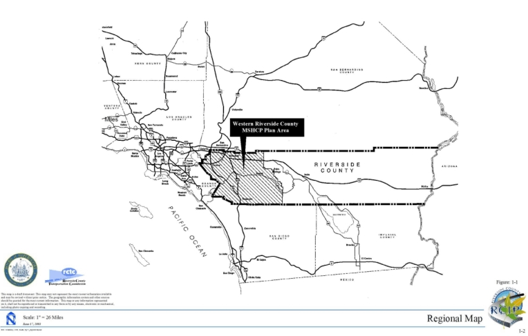
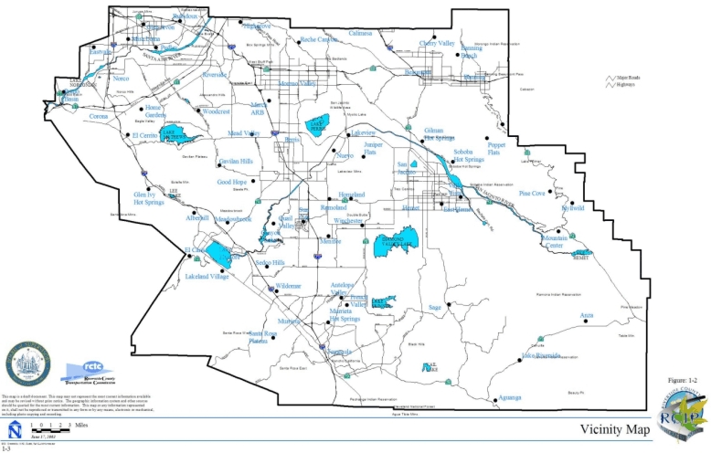
The MSHCP Plan Area encompasses approximately 1.26 million acres (1,966 square miles); it includes all unincorporated Riverside County land west of the crest of the San Jacinto Mountains to the Orange County line, as well as the jurisdictional areas of the Cities of Temecula, Murrieta, Lake Elsinore, Canyon Lake, Norco, Corona, Riverside, Moreno Valley, Banning, Beaumont, Calimesa, Perris, Hemet, and San Jacinto (see Figures 1-1 and 1-2). This HCP is one of the largest plans ever attempted. It covers multiple species and multiple Habitats within a diverse landscape, from urban centers to undeveloped foothills and montane forests, all under multiple jurisdictions. It extends across many Bioregions as well, including the Santa Ana Mountains, Riverside Lowlands, San Jacinto Foothills, San Jacinto Mountains, Agua Tibia Mountains, Desert Transition, and San Bernardino Mountains. It will provide a coordinated MSHCP Conservation Area and implementation program to preserve biological diversity and maintain the region's quality of life.
The MSHCP will serve as an HCP pursuant to Section 10(a)(1)(B) of the federal Endangered Species Act of 1973 (FESA), as well as a Natural Communities Conservation Plan (NCCP) under the NCCP Act of 2001. The MSHCP will be used to allow the participating jurisdictions to authorize "Take" of plant and wildlife species identified within the Plan Area. The United States Fish and Wildlife Service (USFWS) and California Department of Fish and Game (CDFG) (hereafter "Wildlife Agencies") have authority to regulate the Take of Threatened, Endangered, and rare Species. Under the MSHCP, the Wildlife Agencies will grant "Take Authorization" for otherwise lawful actions -- such as public and private Development that may incidentally Take or harm individual species or their Habitat outside of the MSHCP Conservation Area -- in exchange for the assembly and management of a coordinated MSHCP Conservation Area.
The MSHCP's strategy for managing the MSHCP Conservation Area requires a balanced approach. It allocates responsibility for its assembly and long-term management to the County, state, and federal governments, the fourteen Cities in the western County, and private and public entities engaged in construction activities that potentially impact the species covered under the MSHCP. The MSHCP acknowledges the obligation of local projects, both public and private, to mitigate their impacts on species. To encourage Conservation on privately owned lands, the MSHCP's implementation strategy relies heavily on incentives. Where incentives are not sufficient, Conservation will require the purchase of properties from willing sellers.
1.2 PURPOSE AND NEED
1.2.1 Background
Historically, urban Development in Southern California has occurred in the coastal areas of Los Angeles, Orange, and San Diego Counties, resulting in a significant loss of important biological resources in the region. The inland valleys and hillsides of Riverside and San Bernardino Counties have, until recently, remained largely rural, agricultural, and relatively undeveloped. Natural Vegetation Communities that were once common and extensive in Southern California have rapidly declined due to this historic development pattern and to increasing development pressure in the northwestern and southwestern parts of the County over the past 15 years.
The burden of mitigating the effects of urbanization now falls largely on the County, the Cities and private landowners who hold much of the last remaining intact Vegetation Communities in the region. As development pressure has increased, so have conflicts between landowning interests and the state and federal regulatory processes associated with protecting Endangered, Threatened, and rare Species. Conflicts over species Conservation threaten the ability of local jurisdictions to plan for and provide the infrastructure necessary for economic development and a high quality of life in the County.
As urbanization has increased within the County, an increasing number of proponents of public and private Developments have been required to obtain "Take permits" from Wildlife Agencies for impacts to endangered, threatened, and rare species and their Habitats. This process, however, has resulted in costly delays in public and private Development projects and an assemblage of unconnected Habitats created on a project-by-project basis. This piecemeal and uncoordinated effort to mitigate the effects of Development does not sustain wildlife mobility, genetic flow, or ecosystem health, which require large, interconnected natural areas.
The County's population in 2000 was approximately 1.5 million people. Its population is expected to double by 2020, to reach approximately 3.5 million by 2030, and to be approximately 4.5 million by 2040, according to forecasts by the Southern California Association of Governments (SCAG). This is nearly a 400% increase over the next 40 years. Most of Southern California's growth over the next 40 years is expected to occur in the Inland Empire (San Bernardino and Riverside Counties) (SCAG 2001). Accommodating an increase in population of this magnitude will involve urbanizing thousands of acres of undeveloped land and result in significant conflicts with regulations protecting species and their Habitats. Conflicts and delays will escalate costs for all development projects, uncoordinated mitigation efforts will fragment Habitats, the region will miss opportunities to improve the quality of life and economic development opportunities for the current and future residents of the County will also not be realized.
1.2.2 Riverside County Integrated Project
The MSHCP is one element of a comprehensive regional planning effort begun in 1999. To accommodate the County's anticipated growth, the County must provide a range of housing alternatives, encourage economic development, create new jobs at a rate that exceeds its population growth, and build the supporting infrastructure. The natural question is how best to meet the demands of growth while protecting the environment. Local officials recognize that without a well-defined and implementable plan for the future, the County would face a very tenuous future.
To address this complex challenge, the Riverside County Board of Supervisors and the Riverside County Transportation Commission (RCTC) initiated the Riverside County Integrated Project (RCIP). RCIP includes:
Through RCIP, a broad array of stakeholders and individual citizens have been afforded opportunities to participate in the planning process and to communicate to the decision makers the factors that are important to improving their quality of life now and in the future. The purpose of RCIP is to integrate all aspects of land use, transportation, and conservation planning and implementation in order to develop a comprehensive vision for the future of the County.
In addition, a Special Area Management Plan (SAMP) planning process is being pursued to address watershed management and water-quality issues in the region.
On October 20, 1998, the County Board of Supervisors reviewed the following consensus "planning principles" submitted by the coalition of interest groups, and it endorsed their use as initial guidelines in the early stages of developing RCIP:
- Create a new, comprehensive General Plan based on an overall vision of the future rather than piecemeal community plans.
- Ensure that the General Plan anticipates future growth, with a sufficient measure of certainty, and provides for a high quality of life, including reasonable accommodation for housing, biological and multiple species resources, agriculture, watersheds, and scenic landscapes.
- Acknowledge the rights of private property owners in the General Plan and offer just compensation according to federal and state laws regarding private property reserved for public purposes.
- Include positive economic and regulatory incentives, where appropriate, in the General Plan.
- Establish policies in the General Plan so that public benefits, improvements that serve the entire community are funded proportionately by the entire community, and new Developments bear their share of increased infrastructure costs.
- Base community Development in the General Plan on a balanced, sustainable, and integrated set of mapped land uses and promote the continued viability of agricultural lands.
- When mapping areas for Development, consider the following factors:
- location of resource and hazard areas
- opportunity for redevelopment
- availability of infill sites
- proximity of existing infrastructure
- proximity of existing municipal spheres of influence
- conformance with the policies of communities of interest
- appropriately site new towns and villages
- Coordinate the new General Plan with local and regional planning efforts to the maximum extent possible, and encourage mutually reinforcing actions by the Cities and the Local Agency Formation Commissions (LAFCO), as appropriate.
- Plan for and encourage in the General Plan, the development of diverse and distinctive communities.
- Incorporate into the General Plan the goal of creating a more compact urban form that requires less land per capita than current modes of Development.
- Plan for and encourage economic development within the General Plan; emphasize employment opportunities situated within or nearby existing and future communities.
- Integrate the General Plan with transportation planning, so that land use and circulation elements reinforce one another. CETAP should fully examine transit/rail Corridors, and the new General Plan should include them to the maximum extent possible.
- Plan for and encourage within the General Plan, a wide range of housing choices suitable for residents of all economic means.
- Integrate a comprehensive MSHCP into the General Plan.
- Update existing community plans as part of the General Plan planning process to bring them into conformance with revised General Plan policies. Delay finalizing new community plans, if any, and consistency zoning until the new General Plan is completed.
1.2.3 Riverside County Conservation Planning Context
The County has had previous experience with single-species habitat conservation planning including the Fringe Toed Lizard HCP in the Coachella Valley in 1985 and later with the 1996 HCP for the Stephens' kangaroo rat in Western Riverside County. During the Stephens' kangaroo rat HCP planning process, multiple-species planning efforts occurred through the Riverside County Habitat Conservation Agency (RCHCA) and through the Riverside County Regional Parks and Open Space District (RCRPOSD). In June 1992, RCHCA, RCRPOSD, and the Western Riverside Council of Governments (WRCOG) initiated a program to develop a regional multiple-species plan for Western Riverside County. This effort began partially in response to the then-anticipated federal listing of the coastal California gnatcatcher as endangered under FESA. The initial multiple-species planning effort was intended to bring together the diverse assemblage of local and regional plans and develop a coordinated approach to protecting biodiversity on a regional basis. This effort focused on coastal sage scrub Vegetation Communities and resulted in the preparation of a Phase 1 document entitled Information Collection and Evaluation (Pacific Southwest Biological Services [PSBS]/KTU+A, February 1995).
As part of these initial multiple-species planning efforts, a Planning Agreement was drafted between the Wildlife Agencies and participating local entities (see Appendix A of this document.) Section 3 of the Planning Agreement presents the following goals and principles for development of the MSHCP:
- During the development of the MSHCP and the development of both conservation measures and assurances to landowners and users, develop a general agreement regarding the scope, cost, sources of funding, time required for completion, and other important principles concerning the Plan. Develop this general agreement in the first six months of the planning process.
- In comparison to the option of mitigating for species and Habitat impacts on a project-by-project basis, the MSHCP must be more equitable and efficient, and less expensive and less time consuming.
- The MSHCP must produce more biologically effective Habitat and species Conservation than the project-by-project alternative.
- Develop a comprehensive MSHCP that accomplishes the following:
- Promotes the biological viability and recovery of Western Riverside County's ecosystems and Habitats and species dependent thereupon, toward a goal of reducing the need to list additional species in the future.
- Provides a comprehensive means to coordinate, standardize, streamline, and ensure closure regarding mitigation requirements of the FESA, California Endangered Species Act (CESA), National Environmental Policy Act (NEPA), California Environmental Quality Act (CEQA), California Native Plant Protection Act (CNPPA), and other applicable laws and regulations related to biological and natural resources within the Plan Area.
- Assures property owners, local governments, and other affected parties that conservation measures undertaken for species and wildlife Habitat are adequately covered by the MSHCP and will satisfy mitigation requirements of the FESA, CESA, NEPA, CEQA, and CNPPA concerning impacts to those Covered Species and Habitats.
- Establishes and emphasizes the use of incentives to encourage property owners to voluntarily conserve Habitat and species within the Plan Area as an alternative to regulatory mandates.
- Facilitates economic growth and prosperity so that it occurs in a manner consistent with the Conservation of biological resources within the Plan Area.
- Provides the basis for issuance of Incidental Take permits for listed species adequately covered by the MSHCP, by the USFWS and CDFG.
- Provides for issuance of Incidental Take permits for species within the Plan Area that are adequately covered by the MSHCP, both listed and Unlisted Species.
- Establishes consistent mitigation standards for MSHCP Covered Species for potential application by the USFWS under Section 7 of the FESA.
- Equitably distribute costs for the preparation and implementation of the MSHCP among local, state, and federal participants, including equitably distributing costs among both new Development and general contribution. Federal and state contributions shall be made as provided in the Implementing Agreement (IA) and the MSHCP.
- Expedite the MSHCP development and approval process, and complete it within a reasonable period of time, taking into consideration the complexity of the issues involved. All parties agree to use their best efforts to ensure that, if all legal requirements are met, the MSHCP and its environmental documents will be completed and approved within two years of the commencement of the MSHCP planning process.
- Through MSHCP conservation actions, promote the recovery of species that occur within the Plan Area that are listed as threatened or endangered under CESA and/or FESA; taking into account factors related to the range of each species.
- Decisions by all parties must be made in a timely fashion and in compliance with agreed time parameters.
- Actively encourage public input and participation in order to obtain public support for the Conservation and economic benefits that the parties and participants seek from the MSHCP.
The County became the lead for the multiple-species planning effort with the initiation of the RCIP in 1999.
1.2.4 Regulatory Context
The approval of the MSHCP and execution of the IA by the Wildlife Agencies will allow them to issue Take Authorizations to the signatories of the IA. Issuance of Take Authorization to the local jurisdictions will allow Plan participants to implement land use decisions consistent with the MSHCP without project-by-project review and permitting by the Wildlife Agencies. A local, streamlined approach to planning for Endangered/sensitive Species will result in greater economic development certainty and provide for and maintain biological diversity by creating an interconnected MSHCP Conservation Area in the Plan Area. In addition to the preservation of species and associated Habitats, the MSHCP Conservation Area will provide open space and recreational opportunities, which will enhance the quality of life in Riverside County.
➤ Federal Regulatory Framework
Section 9 of the 1973 FESA prohibits the "Take" of wildlife species listed as endangered; it prohibits the Take of species listed as threatened unless otherwise specifically authorized by regulation. Take, as defined by the 1973 FESA, means "to harass, harm, pursue, hunt, shoot, wound, kill, trap, capture, or collect, or to attempt to engage in any such conduct."
In the 1982 amendments to FESA, Section 10 allows for the "Incidental Take" of Endangered and Threatened Species by non-federal entities. The 1973 FESA defines Incidental Take as Take that is "incidental to, and not the purpose of, the carrying out of an otherwise lawful activity. " Prior to 1982, non-federal parties undertaking otherwise lawful activities that were likely to result in Take of listed species risked violating the provisions of Section 9 but had no recourse under the law for exemption. Until that time, only Take occurring during scientific research or conservation actions could be authorized under FESA. The "Incidental Take permit" process was established under Section 10(a)(1)(B) of the 1973 FESA precisely to resolve this difficulty.
Section 10(a)(2)(A) of the 1973 FESA requires an applicant for an Incidental Take permit to submit a "Conservation Plan" or "Habitat Conservation Plan (HCP)." Preparation of this MSHCP complies with this requirement. As outlined in the Habitat Conservation Planning and Incidental Take Permit Processing Handbook, published by the USFWS and the National Marine Fisheries Service (NMFS) in November 1996, under Section 10(a)(2)(A) of the 1973 FESA, and federal regulation [50 CFR 17.22(b)(1), 17.32(b)(1), and 222.22], a conservation plan submitted in support of an Incidental Take permit application must detail the following information:
- Impacts likely to result from the proposed Taking of the species for which permit coverage is requested;
- Measures the applicant will undertake to monitor, minimize, and mitigate such impacts;
- Funding that will be made available to undertake such measures and the procedures to deal with unforeseen circumstances;
- Alternative actions the applicant considered that would not result in Take, and the reasons why such alternatives are not being utilized; and
- Additional measures USFWS may require as necessary or appropriate for purposes of the plan.
USFWS and NMFS published a final addendum to the HCP Handbook on June 1, 2000 (65 FR 35242). This addendum, also known as the Five-Point Policy guidance, provides clarifying guidance for the two agencies in conducting the Incidental Take permit program and for those applying for an Incidental Take permit under Section 10(a)(1)(B) of the 1973 FESA. Developed to promote efficiency and nationwide consistency within and between the USFWS and NMFS and to improve the HCP program, the five components addressed in the policy are: (1) biological goals, (2) adaptive management, (3) monitoring, (4) permit duration, and (5) public participation.
USFWS is charged with implementing not only the 1973 FESA but also the Fish and Wildlife Coordination Act (16 USC 661-666c) and Fish and Wildlife Act of 1956 (16 U.S.C. 742[f] et seq.). However, it is section 10(a)(1)(B) of FESA that authorizes the USFWS to issue a permit pursuant to Section 10(a)(1)(B) for the Incidental Take of species listed as threatened and endangered. Moreover, the legislative history of the Incidental Take permit process clearly indicates that Congress also intended for Unlisted Species to be addressed in HCPs.
"Although the conservation plan is keyed to the permit provisions of the Act, which only apply to listed species, the Committee intends that conservation plans may address both listed and unlisted species. In the event that an unlisted species addressed in the approved conservation plan subsequently is listed pursuant to the Act, no further mitigation requirements should be imposed if the conservation plan addressed the conservation of the species and its habitat as if the species were listed pursuant to the Act (H.R. Report No. 97-835, 97th Congress, Second Session; and 50 FR 39681-39691)."
On February 23, 1998 (63 FR 8859), USFWS and NMFS published the "No Surprises" final rule that revised parts 17 (USFWS) and 222 (NMFS) of Title 50 of the Code of Federal Regulations, which was necessary to implement the HCP assurances. This rule provides that, as long as the HCP is being properly implemented, the federal government will not require any additional lands or money from the Permittee(s) in the event of unforeseen changed circumstances and that additional measures deemed necessary to respond to changed circumstances will be limited to those measures specifically identified in the HCP (and only to the extent of the mitigation specified). Such changed circumstances may involve listing of new species. Changed Circumstances and No Surprises are described in Section 6.8 of this document.
➤ State Regulatory Framework
Section 2080 of the California Fish and Game Code ("FGC") prohibits the "Take" of species listed under the FGC as candidate, Threatened, or Endangered Species. FGC section 1908 prohibits the Take, possession or sale of rare native plants. FGC section 3503 prohibits the Take, possession or needless destruction of the nest or eggs of any bird. FGC section 3503.5 prohibits the Take, possession or destruction of any birds-of-prey or their nests or eggs. The NCCP Act, FGC section 2800 et seq., identifies the process and standards for NCCPs. FGC section 2835 authorizes CDFG to permit the Take of any covered species whose conservation and management are provided for in an NCCP approved by the CDFG. This includes listed (rare, threatened, or endangered) and Unlisted Species.
The state legislature found that NCCPs are an effective tool in protecting California's natural diversity and that they will reduce conflicts between efforts to protect the state's wildlife heritage and the reasonable use of natural resources for economic development. The legislature further found that development of NCCPs promotes the coordination and cooperation among public agencies, landowners, and other private interests, provides a mechanism by which landowners and Development proponents can effectively address concerns about cumulative impacts, promotes conservation of unfragmented Habitat areas, promotes multiple-species and management and conservation, provides one option for identifying and ensuring appropriate mitigation that is roughly proportional to impacts on fish and wildlife, and promotes the conservation of broad-based natural communities and species diversity. NCCPs provide for regional or areawide protection and perpetuation of plants, animals, and their Habitats while allowing compatible land use and economic activity; they are a cooperative planning process that involves local, state, and federal agencies and the public, including landowners, in the MSHCP Plan Area.
The NCCP Act, as amended, FGC section 2830(d), provides for CDFG to authorize the Incidental Take of identified species for NCCPs that are developed pursuant to a Planning Agreement entered into before January 1, 2001, and for which CDFG finds that the plan has been developed using a public participation process and scientific analysis process substantially in conformance with the intent of paragraph (5) of subdivision (b) of Section 2810 and Section 2815.
FGC section 2810, subdivision (b), paragraph (5) addresses the inclusion of independent scientific input to assist CDFG and plan participants to do the following:
- Recommend scientifically sound conservation strategies for species and natural communities proposed for coverage by the plan;
- Recommend a set of reserve design principles that addresses the needs of species, landscapes, ecosystems, and ecological processes in the Plan Area;
- Recommend management principles and conservation goals that can be used in developing a framework for the monitoring and adaptive management component of the plan; and
- Identify data gaps and uncertainties so that risk factors can be evaluated.
FGC section 2815 addresses the public participation process for plan development to ensure that interested persons, including landowners, have adequate opportunity to provide input to lead agencies, state and federal Wildlife Agencies, and others involved in preparing the plan. The public participation process may be achieved through public working groups and advisory committees and includes the following:
- Making the draft NCCP available to the public for review and comment at least sixty (60) days prior to its adoption and providing documents to the public at least ten (10) days prior to any public hearing on the documents;
- Making draft plans, memoranda of understanding, maps, conservation guidelines, species coverage lists, and other planning documents available to the public;
- Using a public outreach program to provide access for persons interested in the plan to obtain information about it.
FGC section 2820(f) authorizes CDFG to provide assurance to plan participants commensurate with long-term conservation assurances and associated with implementation measures pursuant to the approved plan and further states:
When providing assurances pursuant to this subdivision, the department's determination of the level of assurances and the time limits specified in the Implementing Agreement for assurances may be based on localized conditions and shall consider all of the following:
The level of knowledge of the status of the covered species and natural communities.
The adequacy of analysis of the impact of take on covered species.
The use of the best available science to make assessments about the impacts of take, the reliability of mitigation strategies, and the appropriateness of monitoring techniques.
The appropriateness of the size and duration of the plan with respect to quality and amount of data.
The sufficiency of mechanisms for long-term funding of all components of the plan and contingencies.
The degree of coordination and accessibility of centralized data for analysis and evaluation of the effectiveness of the plan.
The degree to which a thorough range of foreseeable circumstances are considered and provided for under the adaptive-management program.
The size and duration of the plan.
If there are unforeseen circumstances, additional land, water, or financial compensation or additional restrictions on the use of land, water, or other natural resources shall not be required without the consent of plan participants for a period of time specified in the Implementing Agreement, unless the department determines that the plan is not being implemented consistent with the substantive terms of the Implementing Agreement.
1.2.5 Public Outreach
Public involvement is an essential element of preparing a regional HCP such as this MSHCP. To ensure that the MSHCP, the General Plan, and CETAP reflect the priorities and vision of the County's residents, a community-outreach program has been at the heart of RCIP. The County gathered initial community input in the summer and fall of 1999 through public meetings and surveys asking County residents what they thought their county should look like in 20 years. Residents expressed concerns about the County's ability to retain the rural environment, to attract high-paying jobs, and to focus growth around current city centers. This initial information was compiled into a "Vision Statement" to guide development of each element of RCIP. The County also set up a website to serve as an information portal for the public to learn about the status of each plan, upcoming meetings, and read/download documents produced during the planning process. RCIP and each of its elements has been the subject of hundreds of community meetings throughout the County. Numerous regularly scheduled meetings with representatives of stakeholders took place during development of RCIP documents between the years 1999-2002. Television, radio, and newspaper were also used during this time period to inform the public. Comprehensive documentation of the public outreach effort is available at the County.
1.2.6 Related Documentation
The MSHCP and CETAP are subject to California Environmental Quality Act (CEQA) and National Environmental Policy Act (NEPA) review and the General Plan is subject solely to CEQA review. The MSHCP's Joint Environmental Impact Report (EIR), required by CEQA, and an Environmental Impact Statement (EIS), required by NEPA, will be prepared in order to document the anticipated environmental consequences of implementing the MSHCP. The County is the local lead agency for CEQA, and USFWS is the federal lead agency under NEPA. While each element of RCIP will be subject to its own environmental document(s), the MSHCP will benefit from programs implemented under the General Plan and analyzed in the General Plan EIR. Although the other components of the RCIP are related through integration of the overall RCIP, the project description for the MSHCP EIR/EIS will be independent of the other two environmental documentation efforts. The MSHCP is also accompanied by an IA.
1.3 GOALS AND OBJECTIVES
The overall goal of the MSHCP is based on the RCIP Vision Statement and supporting policy directives. The MSHCP will enhance and maintain biological diversity and ecosystem processes while allowing future economic growth. Preserving a quality of life characterized by well-managed and well-planned growth integrated with an associated open-space system is a component of the RCIP vision. The MSHCP will result in an MSHCP Conservation Area in excess of 500,000 acres and focuses on Conservation of 146 species. The MSHCP Conservation Area includes approximately 347,000 acres on existing Public/Quasi-Public Lands and approximately 153,000 acres of Additional Reserve Land. The overall goals of the MSHCP are:
Biological Goal: In the MSHCP Plan Area, Conserve Covered Species and their Habitats.
Economic Goal: Improve the future economic development in the County by providing an efficient, streamlined regulatory process through which Development can proceed in an efficient way. The MSHCP and the General Plan will provide the County with a clearly articulated blueprint describing where future Development should and should not occur.
Social Goal: Provide for permanent open space, community edges, and recreational opportunities, which contribute to maintaining the community character of Western Riverside County .
On December 19, 2000, the County Board of Supervisors provided the following specific policy direction for development and implementation of the MSHCP:
- Prepare an MSHCP and draft IA based on Alternative 1 as identified in the October 4, 2000, MSHCP Alternatives Development Document (Dudek 2000).
- Include a conservation analysis that anticipates the participation of all 14 Western Riverside Cities and provides a breakdown of the conservation analysis of the 14 Cities and the County.
- Minimize the need for new local ordinances to ensure implementation of the MSHCP.
- Utilize existing processes (including CEQA) to the maximum extent possible for the implementation of the MSHCP.
- Include a range of incentives for land conservation to facilitate assembly of the MSHCP Conservation Area.
- Identify the number of acres of Conservation that would be accomplished by state and federal agencies (primarily USFWS, CDFG, U.S. Bureau of Land Management (BLM), and California Department of Parks and Recreation [DPR]).
- Provide for an MSHCP Conservation Area that offers assurances that additional CESA and FESA permits will not be needed for future infrastructure development during the term of the Permit.
- Equitably apportion Conservation actions among local, state, and federal governments and new Development. The obligation of new Development shall be assigned in a manner that does not unnecessarily burden new housing and economic development in the Plan Area.
- Include a process that allows farmers to be voluntarily covered for Incidental Take of Covered Species associated with their ongoing agricultural activities.
- Include provisions that allow for the conversion of up to 10,000 acres of uncultivated lands to cultivated lands in a manner consistent with achieving the conservation goals of the MSHCP.
- Focus the acquisition of lands in a manner consistent with achieving the conservation goals of the MSHCP.
- Clearly demonstrate the linkage between Conservation, infrastructure, economic development, housing, and job creation within the County.
- Include measurable goals, criteria, and safety nets that are easily administered by the local jurisdictions and understood by the public.
- Include implementing mechanisms that:
- provide incentives for landowner Conservation;
- minimize the potential for the Wildlife Agencies to suspend or terminate the County's Permit as a result of local jurisdiction action on an individual project;
- minimize the role of the Wildlife Agencies in future decisions regarding individual projects;
- do not imply that the program would result in regulatory takings of property or other Fifth Amendment violations of the Constitution.
- Provide clear guidance to incorporate public use of land consistent with achieving the conservation goals of the MSHCP.
- Ensure that local land-use decisions are made by local jurisdictions.
- Clearly define the process for monitoring and managing the participants as well as the associated costs.