SECTION 2.0
PLAN AREA DESCRIPTION AND SETTING
This section describes the biological setting, land use, and demographic context for the MSHCP Plan Area. It also summarizes data sources used to develop the MSHCP, discusses the limitations of those data sources, and outlines features incorporated into the MSHCP to address those limitations.
The general setting of the Plan Area is characterized by rural, urban and suburban Development intermixed with Agricultural Operations and large areas of undeveloped land. Large blocks of land along the southern, eastern, and western boundaries of the Plan Area consist of National Forest lands. The topography is generally lowland valleys intersected with rolling hills surrounded by mountain ranges. Lowland valleys occur at elevations below 600 m (2,000 ft), and hillsides dominated by scrub/chaparral occur at elevations of 600-900 m (2,000-3,000 ft). Mountainous areas within the Plan Area range from 900 m to over 3,000 m (3,000-10,000 ft) above mean sea level.
2.1 EXISTING BIOLOGICAL SETTING
2.1.1 Data Sources and Limitations
A comprehensive biological and physical database that includes information on vegetation, species occurrences, wetlands, topography, soils, and aerial photography is available for the MSHCP Plan Area and was used in the development of the Plan. This section describes the sources for and limitations of the various data layers used to develop the MSHCP.
MSHCP Vegetation. The MSHCP vegetation map is depicted in Figure 2-1. This map was prepared by Pacific Southwest Biological Services (PSBS) and KTU+A in 1995. The methodology used to assemble the map is described in detail in the Western Riverside County Multi-Species Habitat Conservation Plan Phase I Information Collection and Evaluation Report (PSBS and KTU+A, February 1995). Data sources included aerial photography (1 in. = 2,000 ft, 1992-1993) and existing generalized vegetation maps (California Natural Diversity Data Base [CNDDB], Weislander Statewide Vegetation Survey, U.C. Santa Barbara Southern California Ecoregion "GAP" Analysis, 1991 Dangermond/RECON MSHCP Strategy Report). Methods used to create and interpret vegetation data include aerial photographs, edge matching, digitizing, and geographically registering the data. Areas of concern were ground-truthed. Vegetation types were classified according to Holland (1986).
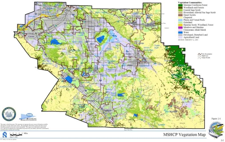
The MSHCP vegetation map is limited by the timeframe within which the data were assembled as well as the precision of those data. The vegetation map represents conditions at the time the data were assembled, in this case 1991-1995; the current extent and character of Vegetation Communities may differ from that depicted on the MSHCP vegetation map. Published and anecdotal data suggest that ecosystem state transition is occurring within some portions of the Plan Area--in particular, fire suppression has resulted in the conversion of frequently burned chaparral and coastal sage scrub to grassland and in shifts from Ponderosa pine and Jeffrey pine to incense cedar and white fir (Minnich et al. 1995; Keeley 1990; Zedler et al. 1983). The MSHCP incorporates features to update the vegetation map as new information is obtained, such as the development of a new vegetation map as part of the MSHCP Monitoring Program. The timing and methodology for developing this map is described in Section 5.3 of this document. This approach is compatible with the criteria-based format of the MSHCP which calls for assembly of 153,000 acres of Additional Reserve Lands from within an approximate 300,000-acre Criteria Area. Reserve Assembly will involve review of a variety of project-specific vegetation data to refine and guide the Reserve Assembly process. This criteria-based format differs somewhat from large-scale NCCPs/HCPs for which a specific reserve boundary is delineated on a map at the time of permit issuance. Under that type of approach, validation of the vegetation map at the landscape level may be more important than under the criteria-based approach selected for this MSHCP. The organizational structure established for the MSHCP, as described in Section 6.6 of this document, also provides opportunities to incorporate new information during the term of the MSHCP Permit.
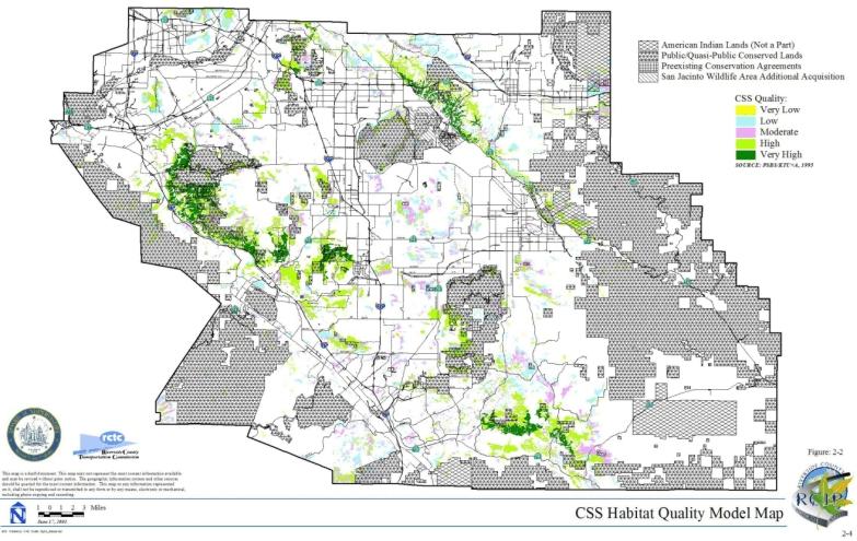
Coastal Sage Scrub Habitat Quality Model. As part of the 1995 PSBS/KTU+A work referred to above in the discussion of MSHCP vegetation, PSBS and KTU+A modeled and evaluated variables potentially relevant to the suitability of coastal sage scrub Habitat within the Plan Area for the coastal California gnatcatcher. This is depicted in Figure 2-2. A detailed description of the methodology used to develop the model is presented in their report (PSBS and KTU+A 1995). Variables used in the model included elevation, degree of slope, patch size, patch shape, proximity to other coastal sage scrub patches, and adjacent land use. The modeling designated the quality of coastal sage scrub in the Plan Area and suitability for the gnatcatcher as very high, high, moderate, low, or very low. The primary limitations of the model with respect to MSHCP planning are the age and quality of the database used to develop the model. In this regard, the model has the same limitations as the MSHCP vegetation map.
MSHCP Species Occurrence Database. The University of California, Riverside (UCR) assembled a species occurrence database for use during the MSHCP planning process. This database is accessible at http://ecoregion.ucr.edu. The web site is a clearinghouse for biological information for the MSHCP. Occurrence data were compiled from museum records, USFWS data, published and unpublished accounts, environmental impact reports, and field notes of local naturalists. As of August 2001, this database contained over 12,800 records.
The UCR species occurrence database incorporates accuracy and precision codes based on the code guides presented below. For the MSHCP species accounts included in Section B of the MSHCP Reference Document - Volume II of the MSHCP, precision of the various occurrence data is cited; less valid data are not used to draw conclusions regarding species Conservation. For example, species locations that have low precision are not valid for defining conservation areas.
UCR Species Occurrences Accuracy/Validity Code Guide
Code 1: Location data from voucher specimens in museums and public-trust institutions (data that can be referenced and reviewed directly).
Code 2: Peer-reviewed journal articles, where information on species distribution has been described at an appropriate scale (data that cannot be reviewed directly but have been published and reviewed by experts in the field).
Code 3: Field notes housed at museums and public-trust institutions, collection records of game agencies, technical reports by government agencies, biological sections of environmental (public-reviewed) documents (data from recognized but unpublished [unreferenced] documents).
Code 4: Field notes of local biologists (data from reasonable sources that may need to be documented by subsequent surveys).
Code 5: Incidental observations by interested parties (data from unconfirmed sources including the lay public that need to be documented by subsequent surveys).
UCR Species Occurrences Precision Code Guide
Precision 1: Location has x, y coordinates or equivalent, e.g., 5 mi west of Hemet on Hwy 74, or location is a relatively small area, e.g., UCR campus, head of Avery Canyon. Location is basically within an area of + 500 m x 500 m.
Precision 2: Location has one x or one y coordinate or equivalent, e.g., 5 mi west of Hemet, or location is moderate in size, i.e., Avery Canyon, small towns, Three Sisters, Strawberry Flat, Tahquitz Valley, Skunk Cabbage Meadow. Location, is basically an area greater than 500 m x 500 m and less than + 2 km x 2 km (up to 3 km x 3 km is OK). This includes small lakes/reservoirs, valleys, and mountains.
Precision 3: Location has no x or y coordinate. May include large areas such as large mountains, e.g., Black Mountain, or vicinity of larger city, e.g., Riverside, Corona, Colton. Location is basically an area greater than 2-3 km x 2-3 km and less than + approximately 8 km x 8 km. This includes large canyons, valleys, lakes, reservoirs, mountains, and mountain ranges.
Precision 4: Location is very ambiguous or vague and/or has been plotted as a "general" location for the purposes of the RCIP project. Examples include San Jacinto Mountains 1,000 m, San Jacinto River, San Gorgonio Pass. Area may be much greater than 8 km2.
Herbarium Data Sources and Limitations
Additional occurrence/distribution data were gathered for particular plant species within the MSHCP Plan Area from herbarium specimens at the San Diego Natural History Museum (SDNHM), Rancho Santa Ana Botanical Gardens (RSA) herbarium, and UCR herbarium. Most of the occurrence and distribution data were downloaded from databases at SDNHM, RSA, and UCR. Additional data were hand copied from herbarium specimens that had not been previously databased (e.g., the synoptic collection at RSA). The location data from each specimen were either copied or translated into one coordinate system to generate a point coverage depicting the spatial distribution of the sensitive plant species within the Plan Area. Approximately 800 data points were assembled with dates ranging from 1880-2001.
Precision codes were applied to individual occurrence records based on the quality and extent of both quantitative and qualitative geographic data using the precision code guide developed for the UCR species occurrence data described above.
Quantitative geographic data included species occurrences whose locations were reported as latitude and longitude in degrees, minutes, and seconds; as UTM coordinates in meters; or as locations described using township, range, and section designations. Species occurrences containing quantitative geographic data are considered to be the most valid and were typically coded Precision 1 or 2.
Qualitative geographic data include species occurrences whose locations were reported as written descriptions. Species occurrences with only qualitative geographic data were generally coded Precision 2, 3, or 4, depending upon the quality of the specific information provided.
It is recognized that new data regarding species occurrences will become available during the MSHCP implementation process including data assembled as part of the MSHCP Monitoring Program described in Section 5.3 of this document. The species-specific conservation objectives and the MSHCP Management Plan contain measures to incorporate new occurrence data as they become available.
Wetlands. Wetlands information for the Plan Area primarily is derived from the MSHCP vegetation map. Other potential wetland areas, including streams, rivers, canals or ditches, ponds, and lakes, were mapped by Earth Consultants International (ECI) as part of the geologic hazards mapping assembled for the RCIP General Plan update. A separate riparian coverage was created by UCR research assistants in 2000 through aerial photo interpretation of 1996 digital orthophoto quarter quadrangles (DOQQs) of the Plan Area. Riparian areas were "heads up" digitized and categorized into four wetland Vegetation Communities based on dominant vegetation cover. All of these data were combined to create an exhibit depicting mapped wetland resources in the Plan Area (Figure 2-3).
The wetlands map has the same limitations as the MSHCP vegetation map, and those limitations are addressed in the MSHCP in the same manner as those for the vegetation map. With respect to wetlands mapping, the U.S. Army Corps of Engineers (ACOE) is currently developing a functional assessment and programmatic wetlands delineation for the San Jacinto River and Upper Santa Margarita River Watersheds within the Plan Area as part of
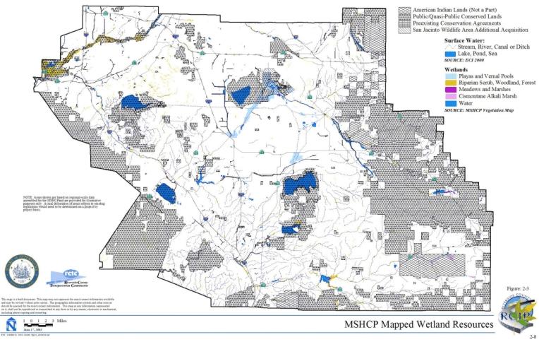
the ACOE Special Area Management Plan (SAMP) process currently underway for those watersheds. A planning level wetland delineation for the San Jacinto and Santa Margarita watersheds was recently completed which was based on a modification of the standard delineation sampling protocols outlined in the Corps of Engineers Wetland Delineation Manual, color infrared image interpretation and field verification visits. The delineation resulted in identification of 201 Vegetation Communities and development of a wetlands ratings system. Although this delineation produced a finer level of aquatic resource mapping, the ACOE wetlands map is limited in that it does not cover the entire MSHCP Plan Area.
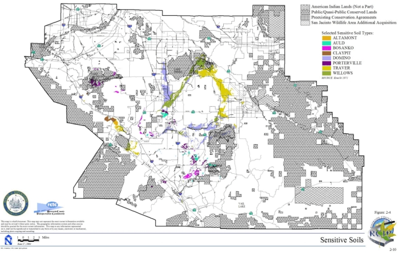
Soils. The U.S. Department of Agriculture, Soils Conservation Service (SCS) (Knecht 1971), and State Soil Geographic (STATSGO) database for California provided the generalized soils map that depicts 25 general soils types for the Plan Area. In addition, the following soil types were digitized from 1973 SCS maps (at a scale of 1:15, 840 or 1 in. = 1,320 ft) and registered with digital Eagle Aerial images onscreen:
Soils were digitized in areas identified by DUDEK biologists to enable quantitative analysis of soils considered important for the Conservation of certain plant species. Soils listed above were digitized for the following U.S. Geological Survey (USGS) quadrangles: Alberhill, Bachelor, El Casco, Elsinore, Hemet, Lake Mathews, Lakeview, Murrieta, Perris, Romoland, San Jacinto, Steele Peak, Sunnymead, Temecula, Wildomar, and Winchester. The digitized soils data layer is depicted in Figure 2-4.
A digital coverage for Delhi soils was also obtained from USFWS and used in the species analysis for the Delhi Sands flower-loving fly. The area currently identified as Delhi soils within the Plan Area may be updated based on site-specific mapping of Delhi soils by a qualified soil scientist within three years after Permit issuance.
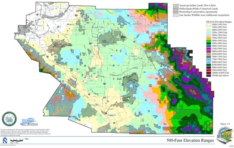
Topography. USGS topography was used for the MSHCP planning process. In addition, specific elevation analyses were developed using a 500-ft interval coverage developed from a USGS 30 m digital elevation model (DEM). A vegetation map with hillshaded relief was also used (see Figures 2-5 and 2-6).
The topographic database is not considered to be limited for purposes of landscape level MSHCP planning. It is anticipated that newly flown, more accurate topography will be available for certain areas for evaluation of specific Covered Activities and other MSHCP Reserve Assembly, management and monitoring issues during the MSHCP implementation process.
Aerial Photography. Aerial photographs were obtained from Eagle Aerial and include digital aerial images flown in fall 1999 for Western Riverside County and flown on May 4, 2001 for the Temecula Valley. Pixel size: 1 m.
USGS Digital Orthophoto Quarter Quadrangles(DOQQs) were obtained from USFWS and cover the majority of the MSHCP Plan Area, with the exception of U.S. Forest Service (USFS) lands. The DOQQs were flown on September 30, 1996, false color infrared, 1m resolution.
The aerial photography database is not considered to be limited for purposes of landscape-level MSHCP planning. It is anticipated that current aerial photography will be available throughout the long-term MSHCP implementation process to permit evaluation of specific Covered Activities and other MSHCP Reserve Assembly, management and monitoring issues as they arise.
Literature. A wide variety of literature was reviewed and used for the MSHCP planning process. Literature citations for the species accounts are provided for each MSHCP species in Section B of the Reference Document, Volume II of the MSHCP. Other literature references are listed in Section D of the Reference Document, Volume II of the MSHCP. It should be noted that a large body of scientific literature was made available to DUDEK by UCR. This literature was thoroughly reviewed but only specifically relevant literature was cited as appropriate. For example, many of the species references contained little or no relevant information for conservation planning in the MSHCP Plan Area.
2.1.2 Bioregions
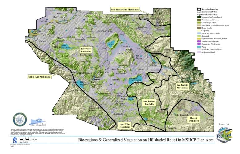
The review of databases and literature shows that the existing vegetation database for the Plan Area does not adequately reflect the considerable variety of plant and animal species in Western Riverside County. Grinnell (1993) described biotic or "life" zones for Southern California, but the scale of these life zones is generally too coarse to be useful for analyzing potential biotic variation within the Plan Area. To address this limitation and better depict potential variation within and among species, a biogeographical map (referred to here simply as Bioregions) was created to help describe diversity of Habitats on a regional scale within the Plan Area; this was done under the assumption that regional diversity in conserved areas translates directly into biological and genetic diversity. By ensuring regional representation of species and redundancy of resources, there is some buffer against the effects of natural and anthropogenic catastrophic events, such as wildfires, floods, and disease, on conserved areas.
Using existing information on soils (Soil Conservation Service), elevation (30-meter digital elevation map data [DEM]), topography (hill-shaded DEM mapping), and local expertise, a draft map that roughly demarcates the general Bioregions within the MSHCP Plan Area was drawn. Existing levels of human disturbance (urbanization, intensive agriculture, grazing, etc.) were considered because they have had a substantial effect on the current biota of the Plan Area. While discrete Bioregion boundaries cannot capture the natural continuum or gradient of environmental changes and transitions within the Plan Area, these boundaries roughly represent areas where species turnover and Habitat zone transitions are pronounced in relation to changes in landform and other environmental features. Because continuous climatic maps showing precipitation and air temperature (maximums, minimums, averages) were not available, landform and elevation were used as surrogates for these variables in order to draw the initial map. DUDEK staff and subconsultants knowledgeable about the distribution of plant and animal species in Western Riverside County then fine-tuned the boundaries where elevation and landforms did not accurately reflect changes in species and Habitat distributions. This methodology is similar to the approach used to develop Bioregions for San Diego County. The validity of these Bioregions was initially tested by examining the distribution of vegetation types and sensitive species that fall within them. On the basis of existing data, it was determined that the Bioregions appear to reflect the different suites of species and Vegetation Communities in the Plan Area. Certainly, field studies to confirm or modify these Bioregions would be desirable. As a work in progress, these boundaries are subject to change based on further analyses, scientific study, and input from experts familiar with Western Riverside County.
Seven distinct Bioregions were identified: Santa Ana Mountains, Riverside Lowlands, San Jacinto Foothills, Agua Tibia Mountains, Desert Transition, San Bernardino Mountains, and San Jacinto Mountains (Figure 2-6). The characteristic features of each Bioregion are described below.
Santa Ana Mountains Bioregion. The Santa Ana Mountains Bioregion extends south of State Route 91 (SR-91) to the Riverside/San Diego County line and occurs west of Interstate 15 (I-15). It encompasses the Cleveland National Forest and areas north of the Santa Margarita River. This Bioregion generally occurs at elevations above 600 m (2,000 ft.) and supports Diegan coastal sage scrub, mesic chaparral, and sparse coniferous vegetation. The Santa Ana Mountains Bioregion is heavily influenced by coastal climate factors, such as fog, rainfall, and wind. This Bioregion is relatively undisturbed and not urbanized.
Riverside Lowlands Bioregion. The Riverside Lowlands Bioregion characterizes areas east of the Santa Ana Mountains Bioregion, south of the Riverside/San Bernardino County line, west of Diamond Valley Lake, Lake Skinner, and Gilman Hot Springs, and north of the Riverside/San Diego County line. This Bioregion encompasses Estelle Mountain, Lake Mathews, Reche Canyon/Badlands, the San Jacinto Valley, Gavilan Hills, Lakeview Mountains, and French Valley. The Riverside Lowlands Bioregion generally occurs at elevations below 600 m (2,000 ft) and is characterized by Riversidian sage scrub and annual grasslands.
The relatively arid climate is in part the result of the rain shadow cast by the Santa Ana Mountains. A high level of disturbance and urbanization are noted within this Bioregion.
San Jacinto Foothills Bioregion. The San Jacinto Foothills Bioregion generally includes areas north of SR-79, east of the Riverside Lowlands Bioregion and west of the San Jacinto Mountains Bioregion. This Bioregion encompasses Vail Lake, Sage, and Cactus Valley. The San Jacinto Foothills Bioregion occurs at elevations of 600-900 m (2,000-3,000 ft) and is dominated by Riversidean sage scrub and xeric chaparral associations. This Bioregion receives less frequent frost and snow than the mountainous areas. This Bioregion has not been heavily disturbed or urbanized.
Agua Tibia Mountains Bioregion. The Agua Tibia Mountains Bioregion extends south from SR-79 to the Riverside/San Diego County line. It encompasses the Agua Tibia Mountains and generally occurs at elevations above 600 m (2,000 ft). This Bioregion supports Diegan coastal sage scrub, mesic chaparral, and sparse coniferous vegetation. The Agua Tibia Mountains Bioregion has not been heavily disturbed or urbanized.
Desert Transition Bioregion. The Desert Transition Bioregion is located in the southeastern portion of the Plan Area and encompasses the Cahuilla Indian Reservation and Lake Riverside area. The Desert Transition Bioregion generally occurs at elevations above 900 m (3,000 ft) and is arid and desert-influenced. This Bioregion supports red shank chaparral, big basin sage scrub, and semi-desert succulent scrub Vegetation Communities. This Bioregion has not been heavily disturbed or urbanized.
San Bernardino Mountains Bioregion. The San Bernardino Mountains Bioregion is located in the northeastern portion of the Plan Area and encompasses areas north of I-10 within the Pass Area Plan; it generally occurs at elevations above 900 m (3,000 ft). This Bioregion supports coniferous forests, montane chaparral, and broad-leaved forest. The San Bernardino Mountains Bioregion is floristically distinct from the San Jacinto Mountains Bioregion. This Bioregion has not been heavily disturbed or urbanized.
San Jacinto Mountains Bioregion. The San Jacinto Mountains Bioregion occurs in the eastern portion of the Plan Area and encompasses the San Bernardino National Forest, Pine Cove, Idyllwild, and upper San Jacinto River and Bautista Canyon Creek. This Bioregion supports coniferous forests, montane chaparral, and broad-leaved forest; it generally occurs at elevations above 900 m (3,000 ft). The San Jacinto Mountains Bioregion is floristically distinct from the San Bernardino Mountains Bioregion. This Bioregion has not been heavily disturbed or urbanized.
2.1.3 Vegetation Communities
The MSHCP vegetation map described in Section 2.1.1 incorporates 50 Vegetation Community classifications. For purposes of MSHCP planning and analysis, the 50 classifications were collapsed to 14; both categories are summarized in Table 2-1.
TABLE 2-1
SUMMARY OF COLLAPSED AND UNCOLLAPSED
VEGETATION COMMUNITIES CLASSIFICATIONS
The MSHCP Plan Area encompasses approximately 1.26 million acres with approximately 871,000 acres (69%) supporting natural vegetation. The 14 Vegetation Communities within the Plan Area include chaparral (434,950 acres), cismontane alkali marsh (1,260 acres), coastal (Diegan and Riversidean) sage scrub (156,450 acres), desert scrubs (14,570 acres), native and non-native grassland (154,140 acres), meadows and marshes (1,020 acres), montane coniferous forest (29,910 acres), playas and vernal pools (7,910 acres), riparian scrub/woodland/forests (15,030 acres), Riversidean alluvial fan sage scrub (7,940 acres), open water (12,210 acres), woodlands and forests (34,300 acres), and unknown (1,350 acres). In addition, approximately 169,480 acres are in agriculture, and the remaining 218,260 acres are considered disturbed or developed land. Section C of the Reference Document, in Volume II of the MSHCP, contains detailed Habitat accounts describing the biogeography, range and distribution, vegetation characteristics, species composition, physical environment, ecosystem processes, community relationships, and threats for each Vegetation Community within the Plan Area. A brief description of each Vegetation Community is provided below.
Agriculture. Agricultural lands include areas occupied by dairies and livestock feed yards or areas that have been tilled for use as croplands or groves/orchards. Approximately 13.5 percent of the Plan Area (169,480 acres) consists of agricultural lands. The largest areas of dairy and livestock feed yards are located north of San Jacinto and north of Juniper Flats in the communities of Lakeview, Mystic Lake, Nuevo, southeast Perris, Eastvale, Lake Norconian off of Bellegrave Avenue, Norco, and in Glen Avon. Field croplands are mapped extensively throughout the Plan Area. The largest areas are around State Route 371 (SR-371) in the vicinity of Anza; in an east-west strip from Murrieta Hot Springs; through French Valley; Antelope Valley; Paloma Valley; Menifee Valley; Winchester; Domenigoni Valley to West Hemet; the Diamond Valley area; and in Eastvale. The largest area of grove/orchard is in Santa Rosa East between Gavilan Mountain and Mesa de Colorado.
Chaparral. Chaparral vegetation is the most abundant and widespread vegetation type in Western Riverside County, covering approximately 35 percent (434,950 acres) of the Plan Area. Large contiguous stands of chaparral occur along the Santa Ana Mountains in the western portion of the Plan Area, and along the San Bernardino, San Jacinto, and Agua Tibia Mountains in the eastern and southern portions. Although chaparral is less common than other vegetation types in the central lowlands of Riverside County, three large chaparral-dominated areas occur on steeper lands near the Gavilan Hills-Gavilan Plateau-Meadowbrook Region, the Lakeview Mountains-Double Butte area, and the Sedco Hills-Hogbacks area.
Chaparral is a shrub-dominated Vegetation Community that is composed largely of evergreen species that range from 1 to 4 m in height (Keeley 2000). The most common and widespread species within chaparral is chamise (Adenostoma fasciculatum) (Hanes 1971). Other common shrub species include manzanita (Arctostaphylos spp.), wild-lilac (Ceanothus spp.), oak (Quercus spp.), redberry (Rhamnus spp.), laurel sumac (Malosma laurina), mountain-mahogany (Cercocarpus betuloides), toyon (Heteromeles arbutifolia), and mission manzanita (Xylococcus bicolor) (Holland 1986). Soft-leaved subshrubs are less common in chaparral than in coastal sage scrub (see below) but occur within canopy gaps of mature stands (Holland 1986; Keeley and Keeley 1988; Sawyer and Keeler-Wolf 1995). Common species include California buckwheat (Eriogonum fasciculatum), sages (Salvia spp.), California sagebrush (Artemisia californica), and monkeyflower (Mimulus spp.). In addition, herbaceous species, including deerweed (Lotus scoparius), nightshade (Solanum spp.), Spanish bayonet (Yucca whipplei), rock-rose (Helianthemum scoparium), onion (Allium spp.), soap plant (Chlorogalum spp.), bunch grasses (Nassella spp., and Melica spp.), wild cucumber (Marah spp.), bedstraw (Galium spp.), and lupine (Lupinus spp.) are also present (Holland 1986; Keeley and Keeley 1988; Sawyer and Keeler-Wolf 1995 ).
Cismontane alkali marsh. Cismontane alkali marsh Vegetation Communities are scattered sparsely over the Western Riverside County region, occupying approximately 0.1% (1,260 acres) of the Plan Area. Cismontane alkali marsh was mapped in two general localities along Cahuilla Creek south of Anza and upstream from Lake Mathews along the Colorado River aqueduct.
Typical cismontane alkali marsh species include yerba mansa (Anemopsis californica), saltgrass (Distichlis spicata), alkali-heath (Frankenia salina), cattails (Typha spp.), common pickleweed (Salicornia virginica), rushes (Juncus spp.), marsh flea-bane (Pluchea odorata), and sedges (Carex spp.) (Holland 1986).
Coastal sage scrub. Coastal sage scrub is distributed throughout Western Riverside County, occupying approximately 12% (156,450 acres) of the Plan Area (PSBS 1995). It occurs from the eastern slopes of the Santa Ana Mountains to elevations in the San Jacinto Mountains less than 1,500 m (5,000 ft). Sage scrub often is distributed in patches throughout its range (O’Leary 1992); over a scale of several miles, it can be found in diverse Vegetation Community mosaics with other plant communities, particularly grassland and chaparral, and oak/riparian woodland in wetter areas. In Western Riverside County coastal sage scrub is found both in large contiguous blocks scattered throughout the County as well as integrated with chaparral and grasslands.
Coastal sage scrub is dominated by a characteristic suite of low-statured, aromatic, drought-deciduous shrubs and subshrub species. Composition varies substantially depending on physical circumstances and the successional status of the Vegetation Community; however, characteristic species include California sagebrush (Artemisia californica), California buckwheat (Eriogonum fasciculatum), laurel sumac (Malosma laurina), California encelia (Encelia californica), and several species of sage (e.g., Salvia mellifera, S. apiana) (Holland 1986; Sawyer-Wolf 1995). Other common species include brittlebush (E. farinosa), lemonadeberry (Rhus integrifolia), sugarbush (Rhus ovata), yellow bush penstemon (Keckiella antirrhinoides), Mexican elderberry (Sambucus mexicana), sweetbush (Bebbia juncea), boxthorn (Lycium spp.), shore cactus (Opuntia littoralis), coastal cholla (O. prolifera), tall prickly-pear (Opuntia oricola), and species of Dudleya.
Desert scrub. Desert scrub, including big sagebrush scrub and Sonoran desert scrub, occurs mostly in the southeastern portion of the Plan Area. Desert scrub occupies approximately 1.2% (14,570 acres) of the Plan Area. Large acreages of the Vegetation Community occur north and south of SR-371 within Tule Valley, Culp Valley, Wilson Creek, Cahuilla, the Ramona Indian Reservation, the community of Anza, and east of Aguanga and Lake Riverside.
Desert scrub is typically composed of shrubs such as big sagebrush (Artemisia tridentata), bitterbrush (Purshia tridentata), rubber rabbit-bush (Chrysothamus nauseosus), yellow rabbitbrush (C. viscidiflorus) black bush (Coleogyne ramosissima), Mormon-tea (Ephedra viridis), horsebrush (Tetradymia canescens), plateau gooseberry (Ribes velutinum) and hopsage (Grayia spinosa), burro weed (Ambrosia dumosa), brittlebush (Encelia farinosa), crucifixion-thorn (Canotia holacantha), ocotillo (Fouquieria splendens), and creosote scrub (Larrea tridentata) (Holland 1986; California Gap Analysis Report 1998). The herbaceous cover generally is dominated by a mixture of perennial bunch grasses, such as ricegrass (Achnatherum hymenoides), needle-and-thread (Stipa comata), letterman’s needlegrass (S. lettermanii), needlegrass (S. occidentalis and S. thurberiana), desert needlegrass (S. speciosa), one-sided bluegrass (Poa secunda), bluebunch wheatgrass (Agropyron spicata), and Great Basin wild rye (Leymus cinereus). Annual grasses and forbs may also occur within big sagebrush scrub. Cheatgrass (Bromus tectorum), an introduced annual grass, has become the dominant herbaceous species in many areas.
Grasslands. Grasslands occur throughout most of Western Riverside County and cover approximately 12.2% (154,140 acres) of the Plan Area. Two general types of grasslands occur in Southern California: (1) non-native dominated, primarily annual grassland ("non-native grassland"); and (2) native dominated, perennial grassland ("valley and foothill grassland") (Heady 1977; Keeley 1989; Sims and Risser 2000). The only valley and foothill grasslands mapped within the Plan Area are distributed over approximately 0.2% (2,700 acres) of the Plan Area on the Santa Rosa Plateau. Non-native grasslands occur throughout the majority of the Plan Area (11.6%), usually within close proximity to urbanized or agricultural land uses. Large patches of non-native grasslands occur in the Riverside Lowlands near March Air Reserve base, Lake Mathews, Lake Perris, Lake Elsinore, near Banning, Cahuilla, and in the Terwilliger Valley south of Anza.
Valley and foothill grasslands typically contain the perennial bunch grasses Nassella pulchra and Nassella lepida. Lesser amounts of other native grasses, such as Melica spp., Leymus spp., Muhlenbergia spp., and beard grass (Bothriochloa barbinodis), may also be present. In addition, non-native grasses or forbs may be present to varying degrees. Native herbaceous plants commonly found within valley and foothill grasslands include yellow fiddleneck (Amsinckia menziesii), common calyptridium (Calyptridium monardum), suncup (Camissonia spp.), Chinese houses (Collinsia heterophylla), California poppy (Eschcholzia californica), tarweed (Hemizonia spp.), coast goldfields (Lasthenia californica), common tidy-tips (Layia platyglossa), Lupinus spp., Plagiobothrys spp., blue dicks (Dichelostemma capitata), Muilla spp., blue-eyed grass (Sisyrinchium bellum), and Dudleya spp. (Holland 1986; Sims and Risser 2000).
Non-native grasslands are likely to be dominated by several species of grasses that have evolved to persist in concert with human agricultural practices: slender oat (Avena barbata), wild oat (A. fatua), fox tail chess (Bromus madritensis), soft chess (B. hordeaceus), ripgut grass (B. diandrus), barley (Hordeum spp.), rye grass (Lolium multiflorum), English ryegrass (L. perrene), rat-tail fescue (Vulpia myuros), and Mediterranean schismus (Schismus barbatus) (Jackson 1985; Sims and Risser 2000).
Meadows and Marshes. Approximately 1,020 acres of meadow and marsh Vegetation Communities, including coastal and valley freshwater marsh, undifferentiated marsh, and wet montane meadow, exist within the Plan Area, comprising 0.08% of the Plan Area. Occurrences of this Vegetation Community have been mapped in the Prado Basin in the Santa Ana River Valley, on the Santa Ana River near Pedley, north of Lake Elsinore in Walker Canyon, near San Jacinto, along the shores of Lake Skinner and Vail Lake, and adjacent to the cismontane alkali marsh on Cahuilla Creek. Undifferentiated marsh was mapped in three locations, including the shore of Lake Mathews, near Mystic Lake, and upstream from Vail Lake along Temecula Creek in the Aguanga Valley. Wet montane meadow was mapped in the San Jacinto Mountains in the San Bernardino National Forest, primarily within the vicinity of Hemet Lake.
Meadow and marsh Vegetation Communities occur in both flowing and still water. This Vegetation Community includes cattails (Typha spp.), bulrush (Scirpus spp.), sedges (Carex spp.), spike rushes (Eleocharis spp.), flatsedges (Cyperus spp.), smartweed (Polygonum spp.), watercress (Rorippa spp.) and yerba mansa (Anemopsis californica), and also contains perennial and biennial herbs (e.g., Oenothera spp., Polygonum spp., Lupinus spp., Potentilla spp., and Sidalcea spp.) and grasses (e.g., Agrostis spp., Deschampsia spp., and Muhlenbergia spp.) (Barbour and Major 1977; Sawyer and Keeler-Wolf 1995; Stephenson and Calcarone 1999; Holland and Keil 1995). Rooted aquatic plant species with floating stems and leaves also may be present, such as pennywort (Hydrocotyle spp.), water smartweed (Polygonum amphibium), pondweeds (Potamogeton spp.) and water-parsley (Oenanthe sarmentosa) (Holland and Keil 1995). Wet montane meadows that dry out by mid-summer have a higher percentage of perennial grasses than meadows that remain moist during the entire growing season (Holland and Keil 1995).
Montane Coniferous Forest. Montane coniferous forest, including Jeffrey pine, lodgepole pine forest, lower montane coniferous forest, mixed evergreen forest, Southern California white fir forest and subalpine coniferous forest, occupies 2.4% (29,910 acres) of the MSHCP Plan Area. It occurs within the San Jacinto Mountains, Agua Tibia, Cleveland National Forest, and Santa Rosa Mountains.
Montane coniferous forest is dominated by Jeffrey pine (Pinus jeffreyi), ponderosa pine (Pinus ponderosa), Coulter pine (Pinus coulteri), lodgepole pine (Pinus contorta ssp. murrayanna ssp. murrayana), limber pine (Pinus flexilis), bigcone Douglas-fir (Pseudotsuga macrocarpa), Pacific madrone (Arbutus menziesii), bigleaf maple (Acer macrophyllum), Rocky Mountain white fir (Abies concolor var. concolor), and sugar pine (Pinus lambertiana). Common understory shrubs include manzanita (Arctostaphylos spp.), California lilac (Ceanothus spp.), chinquapin (Chrysolepis), currant (Ribes), and dwarf mistletoe (Arceuthobium campylopodum). The herbaceous layer is composed of morning-glory (Calystegia occidentalis ssp. fulcrata), sedge (Carex multicaulis), clarkia (Clarkia rhomboidea), and mountain-heather (Phyllodoce breweri).
Playas and vernal pools. These Vegetation Communities comprise 0.6% (7,910 acres) of the Plan Area. Playas and vernal pools are found in Western Riverside County in the San Jacinto Valley/Perris Basin and on the Santa Rosa Plateau.
Vernal pools are ephemeral wetlands that form in shallow depressions underlain by a substrate near the surface that restricts the downward percolation of water. Depressions in the landscape fill with rainwater and runoff from adjacent areas during the winter and may remain inundated until spring or early summer, sometimes drying more than once during the wet season. Smaller pools can fill and dry, and larger pools can hold water longer and may in the deeper portions support species that are more representative of freshwater marshes. Vernal pools are well-known for their high level of endemism (Stone 1990) and abundance of rare, Threatened, or Endangered Species (Sawyer and Keeler-Wolf 1995). Many vernal pools are characterized by concentric rings of plants that flower sequentially as the pools dry. Vernal pools are dominated by native annual plants, with low to moderate levels of perennial herbaceous cover. Common vernal pool plant species in Western Riverside County include woolly marbles (Psilocarphus brevissimus), toad rush (Juncus bufonius), and spike rush (Eleocharis spp.). In addition, the following sensitive or listed plant species are found in one or more of these pools: California Orcutt grass (Orcuttia californica), Coulter’s goldfields (Lasthenia glabrata ssp. coulteri), little mousetail (Myosurus minimus ssp. apus), spreading navarretia (Navarretia fossalis), low navarretia (N. prostrata), Orcutt’s brodiaea (Brodiaea orcuttii), thread-leaved brodiaea (Brodiaea filifolia), Parish brittlescale (Atriplex parishii), Parish meadowfoam (Limnanthes gracilis ssp. parishii), San Diego button-celery (Eryngium aristulatum var. parishii), Wright’s trichocoronis (Trichocoronis wrightii var. wrightii), San Jacinto Valley crownscale (Atriplex coronatavar. notatior), and smooth tarplant (Hemizonia pungens ssp. laevis) (Sawyer and Keeler-Wolf 1995). The Santa Rosa Plateau fairy shrimp (Linderiella santarosae) occurs only in Western Riverside County, which is also the location of the southernmost record for the vernal pool fairy shrimp (Branchinecta lynchi) (Eriksen and Belk 1999).
Riparian forest/woodland/scrub. Riparian vegetation, including forest, woodland, and scrub subtypes, is distributed in waterways and drainages throughout much of Western Riverside County, covering approximately 1.2 percent (15,030 acres) of the Plan Area. Southern cottonwood/willow forest makes up the largest proportion of the riparian vegetation in the Plan Area, comprising nearly one-half (6,610 acres) of the acreage. Most of the southern cottonwood/willow forest Vegetation Community occurs along the Santa Ana River drainage from Lake Evans to beyond the Prado Basin, along the San Gorgonio River north of Banning and along Temecula Creek east of Vail Lake. Additional types of riparian vegetation can be found along the San Gorgonio River north of Banning (montane riparian forest), Temescal Canyon Wash and its tributaries (riparian scrub and mulefat scrub), the stream channels within the San Mateo Canyon watershed (riparian forest, southern sycamore/alder riparian woodland and riparian scrub), and Vail Lake (tamarisk scrub).
Riparian communities typically consist of one or more deciduous tree species with an assorted understory of shrubs and herbs (Holland and Keil 1995). Depending on community type, a riparian community may be dominated by any of several trees/shrubs, including box elder (Acer negundo), big-leaf maple (A. macrophyllum), coast live oak (Q. agrifolia), white alder (Alnus rhombifolia), sycamore (Platanus racemosa), Fremont’s cottonwood (Populus fremontii), California walnut (Juglans californica), Mexican elderberry (Sambucus mexicana), wild grape (Vitis girdiana) giant reed (Arundo donax), mulefat (Baccharis salicifolia), tamarisk (Tamarix spp.), or any of several species of willow (Salix spp.). In addition, various understory herbs may be present, such as salt grass (Distichlis spicata), wild cucumber (Marah macrocarpus), mugwort (Artemisia douglasiana), stinging nettle (Urtica dioica), and poison oak (Toxicodendron diversilobum).
Riversidean alluvial fan sage scrub. Riversidean alluvial fan sage scrub occurs throughout many drainages in the Plan Area and comprises approximately 0.6% (7,940 acres) of the Plan Area. Large acreages of the vegetation occur on the Santa Ana River near Lake Evans in the City of Riverside; along the San Gorgonio River and tributaries near Banning; on the San Jacinto River from the National Forest to the Soboba Indian Reservation; near Temecula along Temecula Creek; the Aguanga area; Bautista Creek south of Hemet; and near Murrieta and Glen Ivy in the Temescal Valley.
Riversidean alluvial fan sage scrub is a Mediterranean shrubland type that occurs in washes and on gently sloping alluvial fans. Alluvial scrub is made up predominantly of drought-deciduous soft-leaved shrubs, but with significant cover of larger perennial species typically found in chaparral (Kirkpatrick and Hutchinson 1977). Scalebroom generally is regarded as an indicator of Riversidian alluvial scrub (Smith 1980; Hanes et al. 1989). In addition to scalebroom, alluvial scrub typically is composed of white sage (Salvia apiana), redberry (Rhamnus crocea), flat-top buckwheat (Eriogonum fasciculatum), our lord’s candle (Yucca whipplei), California croton (Croton californicus), cholla (Opuntia spp.), tarragon (Artemisia dracunculus), yerba santa (Eriodictyon spp.), mule fat (Baccharis salicifolia), and mountain-mahogany (Cercocarpus betuloides) (Hanes et al. 1989; Smith 1980). Annual species composition has not been studied but is probably similar to that found in understories of neighboring shrubland vegetation. Two sensitive annual species are endemic to alluvial scrub vegetation in the Plan Area: slender-horned spine lower (Dodecahema leptocerus) and Santa Ana River woollystar (Eriastrum densifolium ssp. sanctorum).
Water. Approximately 1.0% (12,210 acres) of the Plan Area consists of open water. Open water was mapped at Vail Lake, Lake Skinner, Diamond Valley Lake, Lake Perris, Mystic Lake, Canyon Lake, Lake Elsinore, Lee Lake, Lake Mathews, Hemet Lake, portions of the San Jacinto River, and portions of the Santa Ana River, as well as various small ponds, private reservoirs, and portions of stream channels.
Open water typically is unvegetated due to a lack of light penetration. However, open water may contain suspended organisms such as filamentous green algae, phytoplankton (including diatoms), and desmids (Grenfell 1988). Floating plants such as duckweed (Lemna spp.), water buttercup (Ranunculus aquatilis), and mosquito fern (Azolla filiculoides) also may be present (Holland and Keil 1995). Open water includes inland depressions, ponds, lakes, reservoirs, stream channels containing standing water and often occur in conjunction with riparian and upland Vegetation Communities. Depth may vary from hundreds of meters to a few centimeters.
Woodlands and Forests. The Plan Area supports approximately 34,300 acres (2.7% of Plan Area) of woodlands and forests composed of black oak forest, broad-leaved upland forest, oak woodlands and peninsular juniper woodland Vegetation Communities. Woodland and forest Vegetation Communities are dominated by Englemann oak (Quercus englemannii), coast live oak (Q. agrifolia), canyon live oak (Q. chrysolepis), interior live oak (Q. wislizenii), and black oak (Q. kelloggii) in the canopy, which may be continuous to intermittent or savannah-like. Four-needle pinyon (Pinus quadrifolia), single-leaf pinyon pine (Pinus monophylla) and California juniper (Juniperus californica) are the canopy species of peninsular juniper woodland which most commonly occur in Southern California, forming a scattered canopy from 3 to 15 m tall (Sawyer and Keller-Wolf 1995; Holland and Keil 1995).
Many understory plants in oak woodlands are shade tolerant and include wild blackberry (Rubus ursinus), snowberry (Symphoricarpos mollis), California walnut (Juglans californica), California-lilac (Ceanothus spp.), Rhus spp., currant (Ribes spp.), toyon (Heteromeles arbutifolia), California bay (Umbellularia californica), Engelmann oak, manzanita (Arctostaphylos spp.), laurel sumac (Malosma laurina), poison-oak (Toxicodendron diversilobum) and herbaceous plants including bracken fern (Pteridium aquilinum), polypody fern (Polypodium californicum), fiesta flower (Pholistorma auritum) and miner’s lettuce (Claytonia perfoliata) (Holland and Keil 1995, Sawyer and Keeler-Wolf 1995, Thorne 1976, Brown 1982). Munz and Keck (1968) identify similar species for this Vegetation Community and include that a variety of grasses and soft shrubs also are commonly found. This Vegetation Community can occur on all aspects, on stream sides, canyon bottoms and flat to very steep topography. Woodlands and forests are known to occur throughout the Plan Area.
Developed or disturbed land. Approximately 218,260 acres (17.3%) of developed or disturbed lands occur within the Plan Area. Developed or disturbed lands consist of areas that have been disced, cleared, or otherwise altered. Developed lands may include roadways, existing buildings, and structures. The largest areas of developed land are in the Cities (and surrounding unincorporated communities) of Temecula, Murrieta, Lake Elsinore, Canyon Lake, (Meadowbrook, Alberhill, El Cariso and Lakeland Village), Hemet ( East Hemet and Valle Vista), in Moreno Valley, and along the SR-91 corridor from Riverside through Corona and Norco. More medium-sized tracts of developed land are located in the communities of Canyon Lake, (Quail Valley, Sun City, Homeland), in Perris along I-215, (Mead Valley, Gavilan Hills, Woodcrest), Beaumont, Banning,( Cherry Valley), and Calimesa. Small and scattered occurrences include in the southeast portion of the Plan Area along SR-371 in the unincorporated communities of Terwilliger Valley, Sage, Aguanga and Anza, east of the city of Temecula, and in ( Sedco Hills). Disturbed lands may include ornamental plantings for landscaping, escaped exotics, or ruderal vegetation dominated by non-native, weedy species such as mustard (Brassica sp.), fennel (Foeniculum vulgare), tocalote (Centaurea melitensis), and Russian thistle (Salsola tragus).
Unknown. Approximately 1,350 acres within the Plan Area were not classified into a Vegetation Community during the 1995 PSBS and KTU+A mapping effort.
2.1.4 Species Considered for Conservation in the MSHCP
The species considered for Conservation during the MSHCP planning process are summarized in Table 2-2. As shown in Table 2-2, the initial list of species considered for Conservation included 247 species identified for consideration by the MSHCP Advisory Committee in collaboration with the Wildlife Agencies. Early in the planning process, it was determined that sufficient information was not available for many of these species to proceed with conservation planning. The initial list of 247 species was reduced to 165 species as part of the August 9, 1999 Draft MSHCP Proposal prepared by DUDEK. The list was further refined to 146 species as the MSHCP planning process proceeded and information needed to proceed with conservation planning could not be obtained for certain species. Several species were added to the list during this process as suggested by stakeholders such as the Wildlife Agencies and the California Native Plant Society (CNPS). Species added included great blue heron, Dulzura kangaroo rat, Aguanga kangaroo rat, and six plant species.
Of the 146 Covered Species addressed in the MSHCP, 118 species are considered to be adequately conserved. The remaining 28 Covered Species will be considered to be adequately conserved when certain conservation requirements are met as identified in the species-specific conservation objectives for those species (species-specific conservation objectives for the 146 Covered Species are presented in Section 9.0 of this document). For 16 of the 28 species, particular species-specific conservation objectives, which are identified in Table 9-3, must be satisfied to shift those particular species to the list of Covered Species Adequately Conserved. These 16 species are identified with the superscript (e) in the far right column of Table 2-2. For the remaining 12 species, a Memorandum of Understanding must be executed with the Forest Service that addresses management for these species on Forest Service Land in order to shift these species to the list of Covered Species Adequately Conserved. These 12 species are identified with the superscript (f) in the far right column of Table 2-2. Superscripts (a) through (d) in the far right column of Table 2-2 indicate Covered Species Adequately Conserved for which surveys may be required. Specific survey requirements are included in the species-specific conservation objectives presented in Section 9.0 of this document and in Sections 6.1.2, 6.1.3, and 6.3.2 of this document. A complete summary of MSHCP species survey requirements is provided in Appendix E to this document.
TABLE 2-2
SPECIES CONSIDERED FOR CONSERVATION
UNDER THE MSHCP SINCE 1999
FOOTNOTES:
(1) FEDERAL DESIGNATIONS
FE Endangered: Species listed as endangered by the U.S. Fish and Wildlife Service. Taxa threatened throughout all or a significant portion of their range. The term "endangered species" means any species which is in danger of extinction throughout all or a significant portion of its range other than a species of the Class Insecta determined by the Secretary to constitute a pest whose protection under the provisions of this Act would present an overwhelming and overriding risk to man (Section 3 (6) of the Endangered Species Act).
FT Threatened: Species listed as threatened by the U.S. Fish and Wildlife Service. Taxa likely to become endangered in the foreseeable future. The term "threatened species" means any species which is likely to become an endangered species within the foreseeable future throughout all or a significant portion of its range (Section 3 (19) of the Endangered Species Act).
PT Proposed Threatened: Species proposed for listing as threatened by the U.S. Fish and Wildlife Service
Proposed: Any species of fish, wildlife, or plant that is proposed in the Federal Register to be listed under Section 4 of the Endangered Species Act. The formal process of publishing a proposed federal regulation in the Federal Register and establishing a comment period for public input in the decision-making process. Plants and animals must be proposed for listing as threatened or endangered species, and the resulting public comments must be analyzed, before the UFWS can make a final decision.
Petition: A formal request, with the support of adequate biological data, suggesting that a species be listed, reclassified, or delisted, or that critical Habitat be revised for a listed species.
STATE DESIGNATIONS
SE Endangered: Species classified as endangered by the California Fish and Game Commission. Taxa which are in serious danger of becoming extinct throughout all, or a significant portion, of their range due to one or more causes including loss of Habitat, change in Habitat, over exploitation, predation, competition, or disease (Section 2062 of the Fish and Game Code).
ST Threatened: Species classified as threatened by the California Fish and Game Commission. Taxa which, although not presently threatened with extinction, are likely to become endangered species in the foreseeable future (Section 2067 of the Fish and Game Code).
SSC California or CDFG Species of Special Concern: Species considered by the California Department of Fish and Game as possibly facing extirpation in California due to declining populations or loss of Habitat. Taxa that appear to be vulnerable to extinction because of declining populations, limited ranges, and/or continuing threats.
California Special Concern Species: It is the goal and responsibility of the Department of Fish and Game to maintain viable populations of all native species. To this end, the Department has designated certain vertebrate species as "Species of Special Concern" because declining population levels, limited ranges, and/or continuing threats have made them vulnerable to extinction. The goal of designating species as "Species of Special Concern" is to halt or reverse their declining by calling attention to their plight and addressing the issues of concern early enough to secure their long term viability. Not all "Species of Special Concern" have declined equally; some species may be just starting to decline, while others may have already reached the point where they meet the criteria for listing as a "Threatened" or "Endangered" species under the State and/or Federal Endangered species Acts.
SP Fully Protected: Fully protected species may not be taken or possessed without a permit from the Fish and Game Commission and/or the Department of Fish and Game.
SR Rare: Taxa which, although not presently threatened with extinction, are present in such small numbers throughout their range that they may become endangered if the present environment worsens (Section 1901 of the Fish and Game Code).
Candidate: Taxa which the Fish and Game Commission has formally noticed as being under review by the Department in addition to the list of threatened and endangered species.
(2) The list of species initially considered for Conservation by the Wildlife Agencies in collaboration with the MSHCP Advisory Committee. This list was documented by FWS staff in Tables 1 and 2 prepared in March 1999. Tables 1 and 2 are included in the Appendix to the August 9, 1999 "Draft MSHCP Proposal" (DUDEK 1999) on file with the County of Riverside.
(3) This list of species was developed by DUDEK from the list of species initially considered for Conservation based on preliminary review of the MSHCP database. This list is described in the August 9, 1999 "Draft MSHCP Proposal" (DUDEK 1999) on file with the County of Riverside.
(4) This list of species was developed by DUDEK as a refinement of the list of species included in the August 9, 1999 "Draft MSHCP Proposal." The refinements were based on input from the Wildlife Agencies and a variety of stakeholders as well as additional research conducted by DUDEK. In general, species previously considered for Conservation were eliminated from the list because information needed to proceed with conservation planning for the species was determined to be unavailable.
(5) This list of species was developed by DUDEK as a refinement to the list of species included in the March 7, 2002 Administrative Draft MSHCP and reflects additions recommended by the Wildlife Agencies and CNPS as well as elimination of two plant species for which it was determined sufficient information was not available to proceed with conservation planning. A complete summary of all MSHCP species survey requirements is provided in Appendix E of this document.
(a) Surveys may be required for these species as part of wetlands mapping as described in Section 6.1.2 of this document.
(b) Surveys may be required for these species within Narrow Endemic Plant Species survey area as described in Section 6.1.3 of this document.
(c) Surveys may be required for these species within locations shown on survey maps as described in Section 6.3.2 of this document.
(d) Surveys may be required for these species within Criteria Area as described in Section 6.3.2 of this document.
(e) These Covered Species will be considered to be Covered Species Adequately Conserved when conservation requirements identified in species-specific conservation objectives have been met. Species-specific conservation objectives for these species are presented in Section 9.0 of this document. Please refer to Table 9-3 for specific conservation objectives that must be met for these 16 species prior to including them on the list of Covered Species Adequately Conserved.
(f) These Covered Species will be considered to be Covered Species Adequately Conserved when a Memorandum of Understanding is executed with the Forest Service that addresses management for these species on Forest Service Land. Please refer to Table 9-3.
2.2 LAND USE CONTEXT
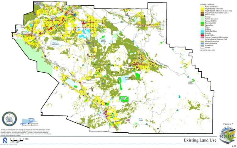
2.2.1 Existing Land Use
Existing land uses within the MSHCP Plan Area can be characterized by developed, agriculture and open space/vacant land categories. Developed land uses include residential uses (single family detached, single family attached, high-density residential, and mobile homes), commercial uses (retail/office and tourist/commercial recreation), industrial uses (light industrial/business park, heavy industrial, mineral extraction, and warehouse), public facilities (utilities, other public facilities, and schools), recreational uses (recreation open space), and rural uses (rural residential). Open space/vacant lands are composed of natural, vacant, and water categories. Figure 2-7 depicts existing land uses within the Plan Area. Approximately 218,260 acres of incorporated and unincorporated County lands are currently developed. A total of 169,480 acres are characterized as agriculture, and 871,040 acres are characterized as vacant land.
2.2.2 Planned Land Use
As outlined in Section 1.0 of this document, the County is developing an updated General Plan for the unincorporated area concurrent with development of the MSHCP. The proposed General Plan incorporates four broad Foundation Component land uses: Agriculture, Rural, Open Space, and Community Development.
2.2.3 Institutional/Political Framework
The MSHCP Plan Area is composed of the jurisdictional boundaries of 14 Cities as well as unincorporated lands within Western Riverside County. Table 2-3 provides a breakdown of acreages for the various Jurisdictions within the Plan Area. As shown, unincorporated County lands comprise approximately 78% of the Plan Area with the remaining approximately 22% comprised of incorporated Cities. County and Cities boundaries are depicted in Figure 2-8.
TABLE 2-3. LAND DISTRIBUTION BY JURISDICTION
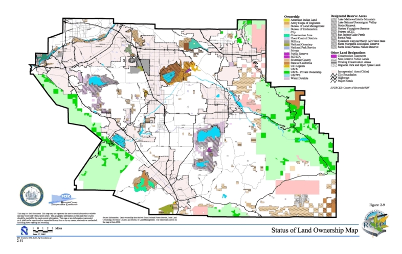
Generalized land ownership within the MSHCP Plan Area is depicted in Figure 2-9. As shown, approximately 67% of the Plan Area is composed of private lands; approximately 3% is American Indian Lands, which are not a part of the MSHCP Plan; and the remaining approximately 30% of the Plan Area is composed of various public ownerships.
Tables 2-4 and 2-5 summarize planned land uses within the MSHCP Plan Area for the unincorporated County lands and the 14 Cities, respectively, based on existing available General Plan data for the County and Cities. As shown, the proposed County General Plan designates a total of 179,940 acres as Community Development, 294,900 acres as Rural, 439,530 acres as Open Space/Conservation, and 30,610 acres as Agriculture within unincorporated County lands in the MSHCP Plan Area (General Plan Update Public Hearing Draft, April 5, 2002). Each of the 14 Cities within the MSHCP Plan Area has its own General Plan. According to the Cities’ General Plans, a total of 222,530 acres would be designated for community development use, 12,190 acres for rural use, 29,840 acres for open space use, and 7,670 acres for agricultural use (WRCOG City General Plan land use database, October 2000).
TABLE 2-4
PLANNED LAND USES WITHIN UNINCORPORATED COUNTY LAND*
Community Development includes the following designations: Very Low Density Residential, Low Density Residential, Medium Density Residential, Medium High Density Residential, High Density Residential, Very High Density Residential, Commercial Retail, Commercial Tourist, Commercial Office, Light Industrial, Heavy Industrial, Business Park, Public Facilities, Community Center, and Freeways.
Open Space includes the following designations: Open Space-Conservation, Open Space-Conservation Habitat, Open Space-Mineral Resource, Open Space-Recreation, Open Space-Rural, and Open Space-Water.
Rural includes the following designations: Rural Residential, Rural Mountainous, Rural Desert. (General Plan Update Public Hearing Draft, April 2002).
TABLE 2-5
PLANNED LAND USES WITHIN INCORPORATED LAND*
Community Development includes the following designations: High Density Residential, Medium Density Residential, Low Density Residential, Very Low Density Residential, Mixed Use, Commercial, Industrial/Business Park, Public Facilities, and Specific Plan Area.
Open Space includes the following designations: Open Space-Mineral Resources, Open Space-Multi-Purpose, Open Space-Recreational, Open Space-Water, and Watercourse Overlay.
Rural includes the following designations: Rural Mountainous and Rural Residential. (WRCOG City General Plan Database, October 2000)
Table 2-6 compares existing and planned land uses within the MSHCP Plan Area. As shown, planned land uses within the Plan Area indicate a shift in future use of land within Western Riverside County. At buildout, approximately 491,300 acres of currently vacant and agricultural lands are anticipated to shift to community Development/rural uses. This shift in land use is planned to accommodate projected growth within the Plan Area. The MSHCP is being prepared to provide for maintenance of biological diversity within the Plan Area through assembly and management of an approximately 500,000-acre MSHCP Conservation Area in the context of this projected growth and anticipated land use shift.
TABLE 2-6
EXISTING vs. PLANNED LAND USE WITHIN WESTERN RIVERSIDE COUNTY
Planned Land Use: County of Riverside General Plan Public Hearing Draft, April 5, 2002 and WRCOG City General Plan Land Use Database, October 2000.
2.3 DEMOGRAPHIC CONSIDERATIONS
2.3.1 Historical Growth
Southern California has experienced periods of rapid growth over most of the past century. As the coastal regions of Los Angeles, Orange, and San Diego Counties have built-out, much of the new growth has shifted to the inland regions of Riverside and San Bernardino Counties. During the 1980s and 1990s, Riverside County led the region in population growth. During the 1990s, Riverside County was also a leader in job growth. In 1970, Riverside County’s total population was 456,916; approximately 224,032 people lived within Western Riverside County Cities, and 178,591 lived within unincorporated areas (it is assumed a majority of unincorporated County occupants reside within Western Riverside County) (Population Estimates for California Cities and Counties, 1970-1980, State of California, Department of Finance Web site at http://www.dof.ca.gov/HTML/DEMOGRAP/repndat.htm, accessed April 2002). By 1980, Riverside County’s total population increased to 663,199. Approximately 291,313 people lived in western County Cities, and 276,565 lived in the unincorporated County (Population Estimates for California Cities and Counties, 1970-1980, State of California, Department of Finance Web site, accessed April 2002). The County’s total population grew from 663,199 in 1980 to 1,170,413 by 1990; western County Cities were populated by 594,046 people with an additional 385,384 people living in the unincorporated County (Revised Historical City, County, and State Population Estimates, 1991-2000, with 1990 and 2000 Census Counts, State of California, Department of Finance Web site, accessed April 2002). The County’s total population grew from 1,170,413 in 1990 to 1,545,387 in 2000. By 2000, a total of 848,413 people resided in western County Cities, and an additional 420,721 resided in unincorporated County areas (Revised Historical City, County, and State Population Estimates, 1991-2000, with 1990 and 2000 Census Counts, State of California, Department of Finance Web site, accessed April 2002).
2.3.2 Forecast Growth
The Southern California Association of Governments (SCAG) and Western Riverside County Cities have historically prepared regional growth forecasts in an effort to allocate resources in the most efficient manner. Forecasts include population, housing, employment, and other economic data. SCAG estimates that by 2025 almost 7 million people and 4 million jobs -- the equivalent of adding two cities the size of Chicago -- will be added to the Southern California region (SCAG 1998, with draft update 2001). This would bring Southern California’s regional population from 16 million to 22.8 million (SCAG 2001). Most of the population growth is expected to occur in north Los Angeles, Riverside, and San Bernardino Counties; however, experts believe job growth will also occur in Los Angeles and Orange Counties.
SCAG released Riverside County’s population forecasts for 2020 in 1998; Riverside’s population is projected to reach upwards of 2.8 million. This population growth equates to approximately 2.8% a year from now until 2020. Population will continue to increase within the County beyond the 2020 horizon; the County’s population will reach 3.5 million by 2030 and 4.5 million by 2040. A total of approximately 569,600 housing units will be needed to accommodate this anticipated growth (approximately 426,400 in Western Riverside County and approximately 143,200 in Eastern Riverside County).
2.3.3 Infrastructure Needs
The demographics clearly lay out the demands associated with growth in population, housing, and jobs that the RCIP is designed to address as discussed in Section 1.0 of this document. Among those are the demands that will be placed on local governments to provide critical infrastructure, municipal facilities, utilities, roads, parks, open space, and the state allocation of affordable housing units. Infrastructure needs are addressed as Covered Activities in the MSHCP as discussed in Section 7.0 of this document. The demographics also foretell the increased stress on natural Habitats, native plants, and animal species. Merely recounting numbers does not truly describe the magnitude of the challenges facing Western Riverside County. Only by looking at the demographics in terms of their impacts on all aspects of the Plan Area’s infrastructure, including the Conservation of natural resources, can Western Riverside County prepare for the future. The RCIP through each of its four elements looks at the impacts of the growth facing the County and begins the process of building the infrastructure necessary to sustain the natural environment and meet the needs of future citizens.