Nexus Report
1. INTRODUCTION
Historically, urban Development in Southern California has occurred in the coastal areas of Los Angeles, Orange, and San Diego Counties, which has resulted in a significant loss of important biological resources in the region. The inland valleys and hillsides of Riverside and San Bernardino Counties have, until recently, remained largely rural, agricultural, and relatively undeveloped. Natural Habitats that were once common and extensive in Southern California have rapidly declined due to this historic Development pattern and to increasing Development pressure in the northwestern and southwestern parts of Riverside County over the past 15 years.
The obligation to mitigate impacts of urbanization, including public infrastructure needed to support future planned residential and nonresidential development, is the responsibility of the County, the Cities and private landowners who hold much of the last remaining intact Habitats in the region. As Development pressure has increased, so have conflicts between landowning interests and the state and federal regulatory processes associated with protecting Endangered, Threatened, and rare Species. Conflicts over species Conservation impact the ability of local jurisdictions to plan for and build infrastructure necessary to support planned development, as well as sustainable economic growth, both of which are necessary to maintain a high quality of life in the County.
In recent years, an increasing number of proponents of public and private Developments in both the incorporated and unincorporated areas of Riverside County have been required to obtain Incidental Take permits from the Wildlife Agencies for impacts to Endangered, Threatened, and rare Species and their Habitats. This past practice of obtaining project specific Incidental Take permits has resulted in costly delays in public and private Development projects and an assemblage of unconnected Habitat areas. This piecemeal and uncoordinated effort to mitigate the effects of Development also does not sustain wildlife mobility, genetic flow, or ecosystem health, which require large, interconnected natural areas.1 Thus, a comprehensive coordinated regional effort is needed to mitigate the effects of Development on Species and their Habitats.
1.1. PURPOSE OF THE MITIGATION FEE NEXUS REPORT
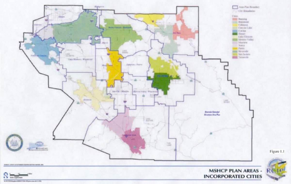
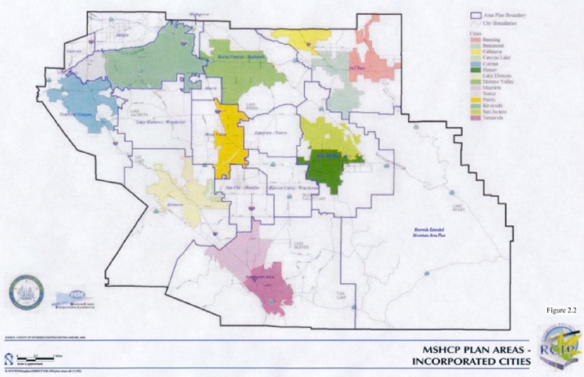
The Western Riverside County Multiple Species Habitat Conservation Plan Mitigation Fee Nexus Report (the "Nexus Report") was prepared to document and establish the legal and policy basis by which a mitigation fee, pursuant to "The Mitigation Fee Act" (California Government Code Section 66000, et seq.), to finance habitat acquisition and other appropriate uses in connection with the Western Riverside County Multiple Species Habitat Plan (the "MSHCP") may be imposed on new development in the MSHCP Plan Area. The MSHCP Plan Area encompasses approximately 1,966 square miles and includes all unincorporated Riverside County land west of the crest of the San Jacinto Mountains to the Orange County line, as well as the jurisdictional areas of the Cities of Banning, Beaumont, Calimesa, Canyon Lake, Corona, Hemet, Lake Elsinore, Moreno Valley, Murrieta, Norco, Perris, Riverside, San Jacinto, and Temecula (Figure 1.1).
1.2. PARTICIPATION IN PREPARATION OF THIS FEE NEXUS REPORT
In April 2003, the "Administrative Review Draft Mitigation Fee Nexus Report for the Western Riverside County Multiple Species Habitat Conservation Plan" (the "Administrative Review Draft") was transmitted to the County and circulated to the Cities via the various technical advisory committees ("TACs") of the Western Riverside Council of Governments ("WRCOG") and presentations were made by County staff and their MSHCP consultant team to various WRCOG committees. In May 2003, based on comments received on the Administrative Review Draft document, the "Revised Administrative Review Draft Mitigation Fee Nexus Report for the Western Riverside County Multiple Species Habitat Conservation Plan" (the "Revised Administrative Review Draft") was prepared and circulated. Once again, County staff and the consultants assisting with preparation of the MSHCP and the Nexus Report presented the Revised Administrative Review Draft document to the WRCOG City Manager and Planning Director's TAC. In fact, several meetings were held with the Planning Director's TAC in which the City's planning directors had a number of comments and suggestions with respect to the Nexus Report (particularly regarding the fee calculation methodology and development horizon used in the Nexus Report). In addition to presenting the Administrative Review Draft and Revised Administrative Review Draft Nexus Report to the WRCOG TACs, presentations have also been made to the MSHCP Advisory Committee and at City Council meetings or study sessions for several of the Cities.
1.3. ORGANIZATION OF THE MITIGATION FEE NEXUS REPORT
The Nexus Report is organized in several sections as follows.
- Introduction - presents an introduction to Riverside County, the Riverside County Integrated Project, and the recommended fee amounts documented in the Nexus Report.
- Riverside County Integrated Project ("RCIP") - presents a summary of the three RCIP components: General Plan, Community and Environmental Transportation Acceptability Process ("CETAP") and the MSHCP.
- Existing Setting - presents a summary of the existing environmental, biological, and transportation setting of Western Riverside County.
- Mitigation Fee Justification Study - presents the analysis required under the Mitigation Fee Act in order for the County and Cities of Banning, Beaumont, Calimesa, Canyon Lake, Corona, Hemet, Lake Elsinore, Moreno Valley, Murrieta, Norco, Perris, Riverside, San Jacinto, and Temecula to adopt a mitigation fee (the "Local Development Mitigation Fee" or "LDMF") to finance a portion of the MSHCP.
- MSHCP Funding/Financing of the Conservation Area Assembly and Management - presents summary of the MSHCP implementation costs and an analysis of the funding sources available to finance the MSHCP.
- Recommendations - presents the consultant's recommendations regarding the Local Development Impact Fee to be adopted.
- Other Funding Issues - presents a summary of FESA requirements, the adequacy of MSHCP funding, and the long term financing approach for management activities.
1.4. RIVERSIDE COUNTY
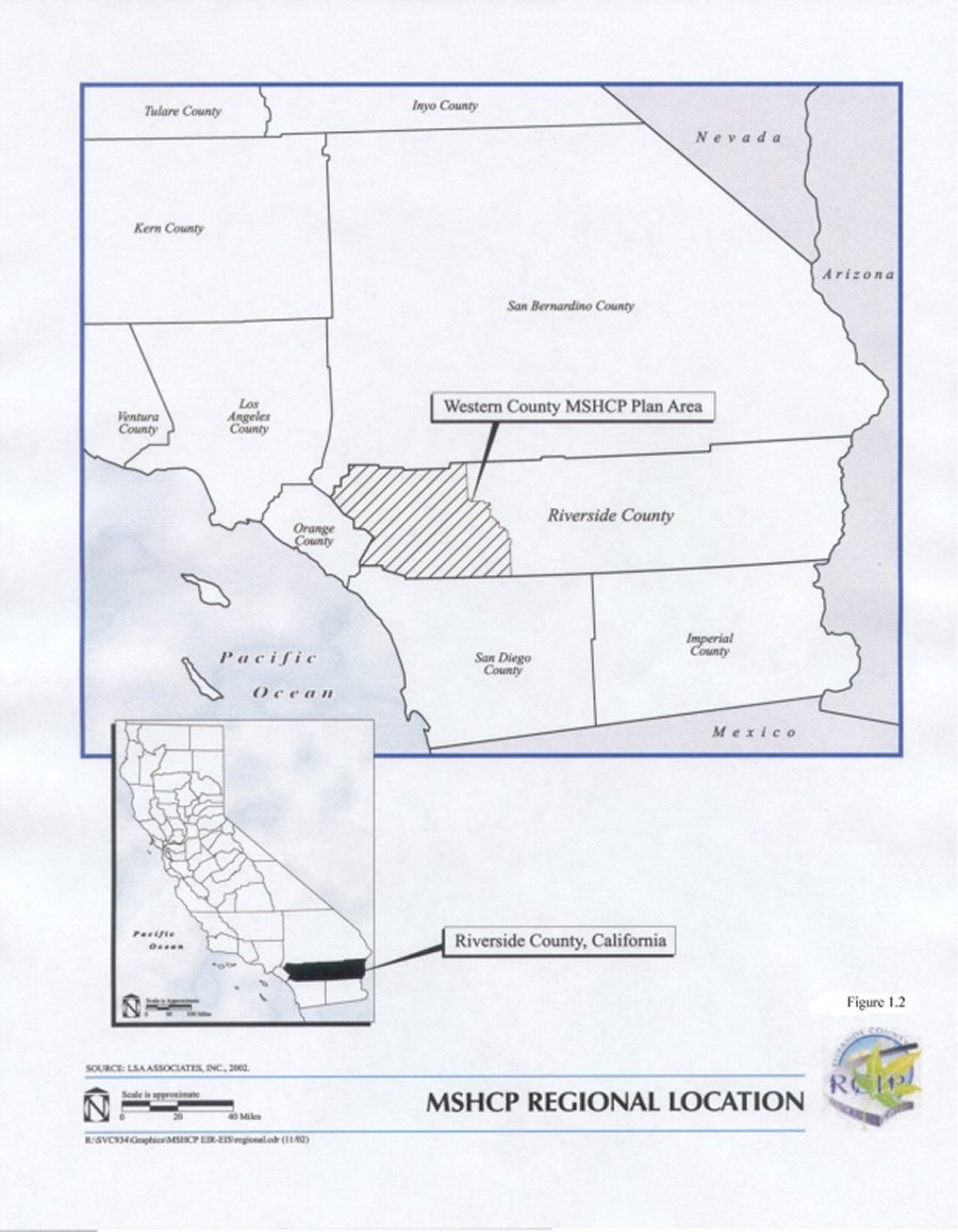
Riverside County, the fourth largest county in California, contains 24 incorporated Cities and numerous unincorporated areas. Riverside County is located in the southern portion of the state and is bordered by San Bernardino and Los Angeles Counties on the north, Arizona on the east, San Diego and Imperial Counties on the south, and Orange County on the west (Figure 1-2). Riverside County, is approximately the size of the State of New Jersey and encompasses approximately 7,400 square miles extending approximately 200 miles west from the Colorado River to the County's western boundary approximately 15 miles east of the Pacific Ocean.
The geography of Riverside County supports a diversity of natural habitat and biological resources that includes deserts, mountains, deep valleys, forests, and rich agricultural lands. In addition to the above-described natural resources, or perhaps as a result of such resources, the County also includes a variety of established and/or growing urban, suburban and rural communities as well as, a variety of agricultural lands, lands devoted to mineral extraction, and recreational areas. Living environments in Riverside County range from dense urban cities, suburban enclaves, and resorts, to rural communities, agricultural communities, equestrian communities and sparsely populated outposts.
The San Jacinto and Santa Rosa Mountains roughly divide Riverside County into eastern and western portions. These two areas of the County have distinct physical characteristics and historic growth patterns. The smaller western portion of the County is approximately half the size of the eastern portion of the County and is bounded by the Santa Ana
Mountains and Cleveland National Forest on the west and the San Jacinto Mountains and the San Bernardino National Forest on the east. Compared to eastern Riverside County, the western portion of the County has experienced the greatest population growth and has a greater concentration of population than the eastern portion of the County. The residents of Western Riverside County are concentrated in the incorporated cities of Banning, Beaumont, Calimesa, Canyon Lake, Corona, Hemet, Lake Elsinore, Moreno Valley, Murrieta, Norco, Perris, Riverside, San Jacinto, and Temecula. Of Riverside County's 24 cities, only these 14 Western Cities would participate in the subject MSHCP.
1.5. RIVERSIDE COUNTY GROWTH TRENDS
Riverside County is one of the fastest growing areas in the State. Between 1994 and 1999, the population in Riverside County increased at an overall growth rate of approximately 7% during that time resulting in approximately 96,000 new residents.2 Results of Census 20003 indicate that Riverside County was home to over 1.5 million people and approximately 585,000 dwelling units in 2000. Year 2020 population and housing estimates prepared by the Southern California Association of Governments (SCAG) project the population and housing stock in the County will nearly double to approximately 2.8 million people and 918,000 dwelling units.4
Another study by the California Department of Finance estimates that the County will continue to grow to 3.5 million people by 2030 and 4.5 million people by 2040. Projections developed for the Riverside County Integrated Project (RCIP) estimated that approximately 1.67 million persons would reside in nearly 558,000 dwelling units in the unincorporated areas of the County by 2040.
Accommodating Riverside County's projected population increase will require the development of thousands of acres of undeveloped land. Conflicts over species conservation threaten the ability of local jurisdictions to plan for and develop necessary infrastructure to provide for a high quality of life as well as accommodate and maintain economic development in Riverside County. Additionally, conflicts over conservation of species and their habitat threaten to fracture species habitats rather than conserve them. Continuation of the current piecemeal process of endangered species protection would likely preclude the possibility of creating a sustainable conservation area that will protect endangered, threatened, and other species and the habitats upon which they rely.
1.5.1 RIVERSIDE COUNTY INTEGRATED PROJECT
In order to maintain and enhance the quality of life and balance the associated housing, transportation, and economic needs of existing and future populations, in view of limited natural resources and the sensitivity of the natural environment, Riverside County undertook a unique and comprehensive planning effort, the Riverside County Integrated Project ("RCIP"). RCIP consists of three integrated plans that provide for future planning, transportation, and conservation needs for the County. These plans are listed below and summarized in Section 2:
1.6. RECOMMENDED FEE AMOUNTS
Table 1-1 presents the Local Development Mitigation Fee amounts to finance the habitat acquisition and other appropriate costs as documented in more detail in Section 4 of this report. The fee amounts in Table 1-1 do not reflect the application of any outside funding sources that may be available to fund a portion of the MSHCP program costs as discussed in Section 5 of the Nexus Report.
2. RIVERSIDE COUNTY INTEGRATED PROJECT (RCIP)
As introduced in Section 1, the County Board of Supervisors and the Riverside County Transportation Commission ("RCTC") initiated the Riverside County Integrated Project ("RCIP") in 1999 in order to comprehensively plan for the demands of the projected population growth, encourage economic development, create new jobs, and provide for the timely construction of infrastructure. As indicated in Section 1.5.1 of the Nexus Report, the RCIP includes 3 components: the 2002 General Plan6, CETAP, and the MSHCP.
The RCIP is unique in that it integrated the processes of land use and transportation planning with habitat preservation for endangered species. Consequently a primary objective of the RCIP is to accommodate projected population growth in the County by focusing development within areas that will be readily accessible to public infrastructure, will provide a good quality of life for future residents, and will minimize environmental impacts, including impacts to sensitive habitats, endangered species, and aquatic resources.
2.1. GENERAL PLAN
State law requires all counties and cities in the State to prepare and maintain a general plan for the long-term growth, development, and management of the community. The general plan acts as a charter for development, and is a city's or county's lead legal document in relation to growth, development, and resource management issues. The law further requires that a city's or county's development regulations (e.g., zoning and subdivision standards) be consistent with its General Plan.
The 2002 Riverside County General Plan7 (the "General Plan") consists of separate elements8 addressing: land use, circulation, multipurpose open space, safety, noise, housing, air quality, and administration which articulate the vision, issues, and County policies regarding the appropriate type and intensity of land use for every parcel within unincorporated Riverside County. Using text and maps, the General Plan identifies lands for housing, business, industry, public facilities, recreation, and other uses. As the blueprint for the future of Riverside County, the General Plan describes anticipated future growth, development, and environmental management programs over the long term. It is the foundation for growth and land-use-related decision-making with respect to public and private development, within unincorporated Riverside County. The General Plan expresses the community's goals regarding the manmade and natural environments and sets forth policies and implementation measures to achieve those goals for the welfare of those who live, work, and do business in Riverside County.
With respect to the Nexus Report, two features of the General Plan are germane to the determination of the mitigation fee amount: Area Plans9 and the land use Foundation Components. Each of these features is discussed below.
2.1.1 AREA PLANS
This brief introduction to the area plan concept is included to acquaint the reader with the Area Plan concept. Area Plans are germane to the Nexus Report since they are used in determining the local acquisition costs as discussed in Section 4.8.
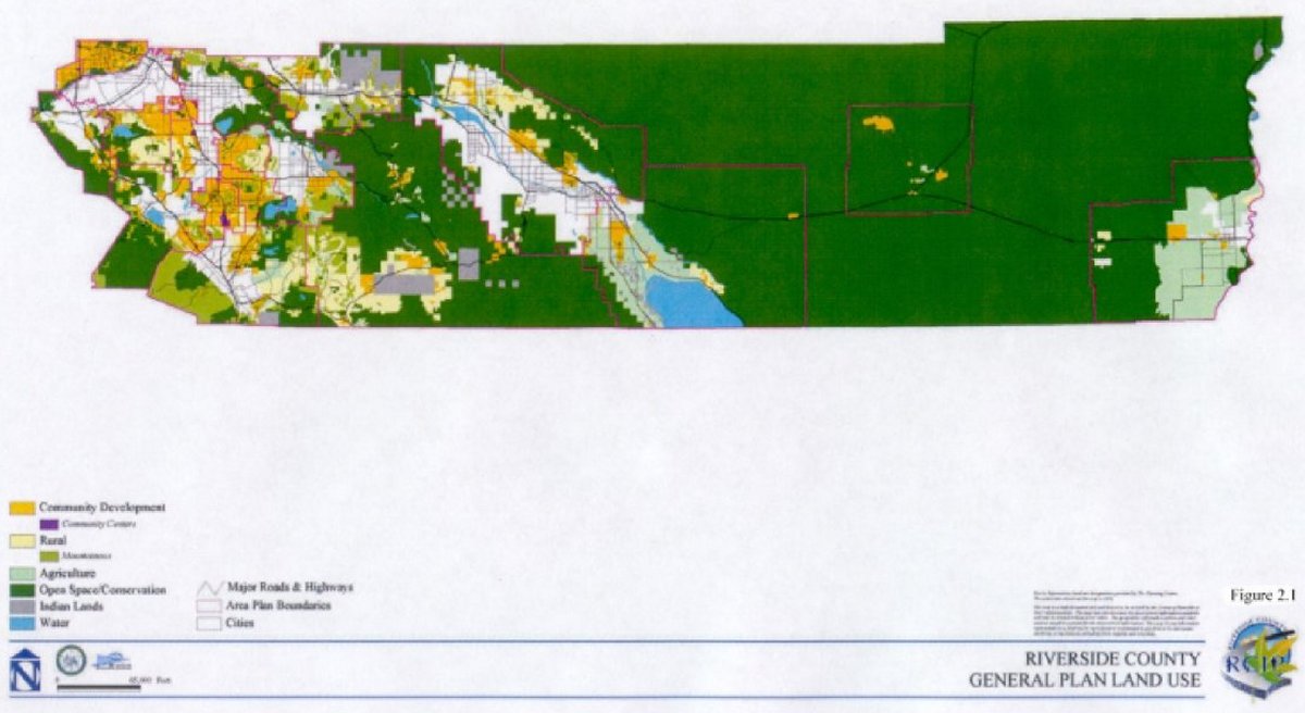
The General Plan consists of two levels of policies that direct land use and development in the County: 1) Policies that are applicable to the entire unincorporated area and are contained in the General Plan and reflected on the General Plan Land Use Map (Figure 2.1); and 2) focused policies that address specific regional or local issues which found in individual Area Plans.
The Area Plans include a land use map, specific policy direction regarding local issues such as land use, circulation, open space, and other issues unique to each of the 19 Area Plans identified in Table 2-1 and shown on Figure 2.2.
2.1.2 FOUNDATION COMPONENTS
In general terms, the Public Hearing Draft General Plan dated April 5, 2002, maps areas suitable for development, areas suitable for agriculture, and areas to be permanently conserved by designating all parcels in the unincorporated area of the County into one of four Foundation Components: Community Development, Rural, Agricultural, and Multipurpose Open Space as indicated on the General Plan Land Use Map (Figure 2.1). Foundation Components are basic to the entire process of land management in the County and accommodate a prescribed array of uses.
Multipurpose Open Space is the least intensive, followed by Agriculture, then Rural, and finally, Community Development.11 The Community Development component is intended to accommodate the greatest amount of anticipated growth.
As discussed in Section 4 of this report, the Foundation Components are one of the factors considered in the estimated costs of assembling the local acquisition portion of the Additional Conservation Lands.12
2.2. COMMUNITY ENVIRONMENTAL AND TRANSPORTATION ACCEPTABILITY PROGRAM (CETAP)
Orderly development requires the efficient and effective transportation of people and goods. In order to achieve these objectives, the Community Environmental and Transportation Acceptability Program ("CETAP") component of RCIP identifies regional transportation corridors to meet the future transportation needs of Riverside County. CETAP goes beyond a typical circulation element13 in that it recognizes that transportation occurs between the various jurisdictions in Riverside County (i.e. unincorporated and incorporated areas) as well as between Riverside County jurisdictions and neighboring counties. CETAP is a multi-modal planning effort consisting of highway options, transit, and other forms of travel demand management and goods movement.
CETAP proposes two different corridors within Riverside County: a Winchester to Temecula corridor (the "WT Corridor") and a Hemet to Corona/Lake Elsinore corridor (the "HCLE Corridor"). CETAP also proposes two "bi-County" corridors, the San Bernardino to Moreno Valley corridor (the "SBMV Corridor") and the Orange County to Riverside County corridor (the "OCRC Corridor"). Proposed current alternatives for the San Bernardino connection focus on a connection from the SR-60 freeway in the western portion of Moreno Valley to the I-10 freeway in the Loma Linda/Redlands area of San Bernardino County.
The design concept for the CETAP corridors includes: 1) six mixed flow lanes (three in each direction) and two high occupancy vehicle (HOV) lanes (one in each direction); 2) sufficient right-of-way-width to meet Caltrans' standards for freeway shoulders and medians; 3) sufficient right-of-way for an exclusive transitway for either rail or bus; 4) buffer areas and areas for utilities; and 5) interchanges at existing freeways.14
2.2.1 REGIONAL PLANNING CONTEXT
Planning for future transportation improvements in the six-county region of the Southern California Association of Governments (SCAG) is addressed in the Regional Transportation Plan (RTP), which was adopted in 2001. The RTP policies for western Riverside County reflect the goal to implement regional transportation improvements intended to satisfy future traffic demand in western Riverside County and achieve SCAG's long-range transportation planning goals to reduce traffic congestion and improve air quality within the region. The RTP is updated every three years.
The RTP was developed pursuant to federal requirements and policies and sets forth a multimodal, financially feasible planning strategy for southern California, including Riverside County. Additionally, the RTP set forth transportation policies and improvements necessary to achieving mobility goals to year 2025 after taking projected population growth and economic factors into account.
The RTP may be amended to substitute new or revised transportation improvements, if the proposed amendments will better accomplish future mobility goals. The alternative ultimately selected through the RCIP/CETAP process to increase mobility will be included as a specific transportation route in the RTP. Currently, the CETAP corridors are included in the 2001 RTP as generalized major transportation studies.
2.2.2 THE WINCHESTER TO TEMECULA CORRIDOR
The Winchester to Temecula Corridor (the "WT" Corridor) is intended to:
"...provide multimodal transportation improvements that will help alleviate future traffic demands and congestion and improve the movement of people and goods between the Winchester area and the existing Interstate corridors."15
The CETAP alternative selected for the WT Corridor is projected to reduce travel time between Winchester and Temecula in the future compared to future conditions without implementation of the WT Corridor.
2.2.2.1. Transportation Benefits from the WT Corridor
Without transportation improvements beyond those currently planned in western Riverside County, future development will not have adequate access to the regional transportation system, resulting in increased local and regional traffic congestion, and inadequate mobility on existing facilities, including regional highways and local arterials within the study area. There is a lack of an efficient north-south connection to address the projected movement of people and goods 25 years from now within the interior of western Riverside County.
Adequate transportation infrastructure is needed to support the projected job growth in the Hemet/San Jacinto, Temecula, Murrieta, and the I-215 Corridor areas. The particular need in the WT Corridor is for high-speed access to Interstate 10 and Interstate 15, allowing for better access to markets, customers, and suppliers in San Diego, Mexico, the Coachella Valley, and points to the east along Interstate 10.
Sections of particular concern are SR-79 (Winchester Road) in the City of Temecula and the I-15 in the cities of Temecula and Murrieta. As development occurs in this corridor, traffic will increase well beyond the capacity of SR-79 to accommodate it. Just east of I15, projected volume for year 2025 on SR-79 is 100,000 vehicles per day, representing Level of Service (LOS) F for seven hours per day.16 In addition, through traffic in this area has little choice but to use SR-79 through the core commercial area of the City.
Over time, as the interior of western Riverside County develops commercially, through truck traffic will increase on SR-79. The commercial nature and volume of through traffic is not compatible with SR-79 as an arterial street serving local commercial properties. I-15 between SR-79 and I-215 is projected to carry over 250,000 vehicles in year 2025, operating at LOS F. This level of congestion will result in substantial spillover traffic to city streets.
I-15 is also a critically important goods movement corridor, linking San Diego and Mexico with the Inland Empire (Riverside and San Bernardino Counties) and the greater Los Angeles region. Trucks make up approximately 15 percent of the traffic volume on I-15. One of the major reasons for the high level of traffic demand on I-15 near Temecula is the convergence of major roadways (I-15, I-215, and SR-79). The I-215 and SR-79 terminate within three miles of each other at the I-15. With the I-15 already carrying heavy volumes as the main north-south freeway for this portion of western Riverside County, the problems are intensified by the convergence of these roadways in the same area. I-15 is an eight lane to ten lane freeway in this area and can accommodate the current volumes of traffic; however, LOS F conditions will occur in 2025. Relief of future traffic congestion on I-15 through Temecula has been a consideration in the development of alternatives for this corridor.
As a six-lane facility, SR-79 east of I-15 in Temecula (Winchester Road) is currently carrying 34,000 vehicles per day. With few other existing east-west roadways in the City of Temecula, mobility is severely hampered for motorists during the peak periods. This specific lack of east-west mobility will increase pressures on existing east-west roadways and unnecessarily increase travel on north-south facilities. This will exacerbate both the local and regional traffic problems as traffic volumes on both the SR-79 and I-215 corridors increase.
The City of Temecula estimates that 25 percent of the workers living in that city travel to jobs in the San Diego region (source: commuter surveys of Temecula residents conducted by City of Temecula). As the San Diego region expands northward, this trend is expected to continue. Likewise, as growth moves northward from the Temecula/Murrieta area, the amount of travel through the cities to the San Diego region will increase. This will create an increasing problem of through traffic, including through truck traffic, traveling on the local streets of the cities of Temecula and Murrieta.
It is anticipated that the selected CETAP alternative for the WT Corridor will reduce travel time between Winchester and Temecula in the future compared to future conditions without implementation of the proposed action. In addition, it is anticipated that the selected alternative will reduce future traffic volume and congestion on I-15 in Temecula, reduce future traffic volumes on Winchester Road east of I-15, and improve average study area traffic speed.
Table 2-217 shows differences in daily vehicle miles of travel ("VMT"), vehicle hours of travel ("VHT"), and average speed for all 2025 alternatives in the WT Corridor as compared with the 2025 base run. The differences are summarized at two levels: the WT Corridor study area, and western Riverside County. The corridor study area statistics are most directly applicable to the identification of average benefit among the various alternatives being considered in this corridor. The change in average speed is the most important distinguishing feature among the alternatives. It most directly relates to the purpose and need defined for the WT Corridor. The table also estimates the magnitude of annual user benefit for year 2025 in today's dollars. Transportation agencies typically assign a dollar value to a vehicle-hour of time saved. The values shown in Table 2-2 were developed using a value of $10 per vehicle-hour, a conservatively low value.
All WT Corridor alternatives show a general increase in average speed and reduction in VHT as compared to the base run, especially in the WT Corridor study area, since these alternatives are included primarily to serve north-south travel. However, there is an increase in VMT in the WT Corridor study area, with the exception of one alternative. The increases in VMT are primarily due to added capacity in the north-south direction and the diversion of traffic from roadways outside the corridor to roadways within the corridor. The higher average speed indicates a more efficient network. The savings in VHT are best assessed from the statistics for all of western Riverside County in Table 2-2. The VHT reduction for western Riverside County may appear to be small on a percentage basis, but are still very significant in terms of total delay savings and associated economic benefit. Alternative 5b, for example, would generate approximately 42 million dollars in economic value of time savings annually. When summed over the life of the project (usually assumed to be at least 40 years for major infrastructure), the total benefit is substantial, even though the percent change may be small.
The peak hour LOS, for the 2025 Base and the LOS for each of the alternatives have been analyzed for selected segments. With the exception of one alternative, all the alternatives in the WT Corridor operate at LOS C or better. Alternative H operates at LOS F on I-15 in the Temecula area, due to the high future traffic demands on that alternative. In some cases the WT alternatives improve operations on other roadways in the study area, and in other cases operation may worsen. Generally, roadways that parallel an alternative improve in level of service; roadways that feed into the alternatives may be impacted with higher volumes. However, the overall benefits of any selected alternative will enhance the LOS from what it is under the base run.
2.2.3 THE HEMET TO CORONA/LAKE ELSINORE CORRIDOR
The Hemet to Corona/Lake Elsinore Corridor (the "HCLE" Corridor) is intended to:
"…provide multimodal transportation improvements that will help alleviate future traffic demands and congestion and improve the east-west movement of people and goods across western Riverside County."18
It is anticipated that the selected CETAP alternative for the HCLE Corridor will reduce future travel time between Hemet and Corona/Lake Elsinore when compared to future conditions without implementation of the HCLE Corridor. Additionally, it is anticipated that the HCLE Corridor will reduce future traffic volume and congestion on SR-91 and SR-60/I-215 in the City of Riverside and improve average traffic speed in the HCLE Corridor study area.
2.2.3.1. Transportation Benefits from the HCLE Corridor
As discussed in the "Draft Environmental Impact Statement/Environmental Report Hemet to Corona/Lake Elsinore Corridor" (July 2002), adequate transportation infrastructure is needed to support the projected job growth in the Hemet/San Jacinto, Temecula, Murrieta, Banning/Beaumont/Calimesa, and the I-215 Corridor areas. The particular need in the HCLE Corridor is for high-speed access to I-15, I-215, and SR-79. For example, there are currently no reasonable transportation facilities for the movement of goods from the SR-91 corridor into the areas being designated for commercial development along I-215. Trucks must be routed along SR-91 and SR-60/215, which are highly congested now and are predicted to be more congested in the future. Existing arterials are not designed to support the anticipated goods movement activity. Even though SR-74 between I-15 and I-215 will be widened to four lanes within the next two years, the route passes through the middle of downtown Perris, and is not suitable for the movement of trucks or higher volume traffic. Also, Cajalco Road is a two-lane rural, winding roadway between I-15 and I-215, and passes through the Stephens' Kangaroo Rat Conservation Area to the south of Lake Mathews. SR-60/I-215 in the Box Springs area serves as the only other freeway access into the area, and this route is heavily congested and is only an indirect route from the Corona area and points to the west.
Some of the specific employment locations for which east-west access is a concern include March Air Conservation Area Base, the Sun City/Menifee employment area, the employment areas immediately north and east of the City of Perris, and the I-215 corridor. These areas will require improved connections to Interstate 10 to and from the east, to I-15 toward Corona and Ontario, and SR-91 with connections to Orange County and Los Angeles.
Many of the segments are projected to be operating at LOS F in year 2025. This will lead to degradation in the movement of people and goods on the transportation network to and from Hemet. Traffic on SR-60/I-215 in Box Springs is projected to increase from 170,000 vehicles per day to over 300,000 per day, well in excess of what this section of roadway can handle even with the addition of improvements already planned and programmed. One of the reasons for the projected increase in congestion on SR-60/I-215 is the lack of other major east-west transportation facilities.
As a point of reference, Riverside County has established, as a Countywide target, a Level of Service C on all County maintained roads and conventional State Highways, with LOS D allowed in areas planned for urban development. According to the 2000 Highway Capacity Manual (HCM), LOS is categorized by two parameters of traffic; uninterrupted and interrupted flow. Uninterrupted flow facilities (e.g., freeways) do not have fixed elements such as traffic signals that cause interruptions in traffic flow. Interrupted flow facilities have fixed elements that cause an interruption in the flow of traffic, such as stop signs and signalized intersections along arterial roads. Of the east-west routes discussed previously, SR-91 is the most heavily traveled facility, with a peak hour demand of nearly 11,000 vehicles in the PM peak hour eastbound east of I-15 (west of McKinley) and a LOS F rating. A freeway lane can carry approximately 2,300 vehicles per hour. SR-60/I-215 in the Box Springs area carries over 7,000 vehicles in the PM peak hour, also a LOS F.
Table 2-319 shows the expected 2025 differences in daily VMT, VHT, and average speed for all alternatives in the HCLE Corridor as compared with the 2025 base run. The differences are summarized at two levels: the HCLE Corridor study area, and western Riverside County. The corridor study-area statistics are most directly applicable to the identification of greatest benefit among the various alternatives being considered in this corridor. The change in average speed is the most important distinguishing feature among the alternatives. It most directly relates to the purpose and need defined for this corridor. The peak period VMT, VHT, and average speeds show patterns similar to the daily statistics in terms of percentage differences and, therefore, are not shown. The table also estimates the magnitude of annual user benefit for year 2025 in today's dollars. Transportation agencies typically assign a dollar value to a vehicle-hour of time saved. The values shown in Table 2-3 were developed using a value of $10 per vehicle-hour, a conservatively low value.
All HCLE alternatives show a general improvement in average speed as compared to the base run, especially in the Hemet to Corona/Lake Elsinore study area, since these alternatives are included primarily to serve east-west travel. However there is also an increase in VMT and VHT in the Hemet to Corona/Lake Elsinore Corridor. This is primarily due to added capacity in the east-west direction and the diversion of traffic from roadways outside the corridor to roadways within the corridor. The higher average speed indicates a more efficient network.
The savings in VHT are best assessed from the statistics for all of western Riverside County in Table 2-3. The VHT reduction for western Riverside County may appear to be small on a percentage basis, but are still very significant in terms of total delay savings and associated economic benefit. The average Annual Benefit generates approximately $37.1 million in annual economic value of time savings. When summed over the life of the project (usually assumed to be at least 40 years for major infrastructure), the total benefit is substantial, even though the percent change may be small.
For the 2025 Base Condition, that is without the HCLE corridor, most of the east-west facilities in the area, including SR-91, SR-60, Ramona Expressway and SR-74, show LOS E to F at a number of segments in both directions during the PM peak hour, indicating high levels of congestion. There is no high-capacity east-west highway south of SR-60 in the study area. This leads to most east-west facilities to serve future development facing excessive congestion during the PM peak hour. The pattern of deficient facilities in the study corridor suggests the need for additional high-speed capacity in the east-west direction between I-15 and SR-79. The following provide some overall conclusions from the traffic analysis regarding the effects of the HCLE Corridor alternatives on vehicular traffic operations in the project study area:
All of the HCLE alternatives operate at LOS D or better in year 2025. In some cases, the alternatives improve operations of other roadways in the study area and in other cases operations may worsen. Generally, roadways that parallel an alternative improve in LOS; roadways that feed the alternatives may be impacted with higher volumes. The farther south the alternative, the less traffic relief provided to SR-60 and SR-91. The farther south the alternative, the lower the reduction in travel time for businesses in the key commercial growth areas along I-215 in the Perris to Moreno Valley area. Even though the percentage reductions in VHT may appear to be small, the total benefit in delay savings and in economic terms is substantial for most alternatives.
2.2.4 SAN BERNARDINO TO MORENO VALLEY CORRIDOR
The SBMV Corridor will be located in the vicinity of I-215 and Ironwood Avenue, Riverside County and extend to California Street in San Bernardino County. This facility will be tunneled under the Box Springs Conservation Area. The tunnel portals will be sited outside of the Criteria Area. The Corridor will proceed east from Box Springs Conservation Area generally along Center Street and span Reche Canyon Road before entering San Bernardino County. This SBMV Corridor is a covered activity under the MSHCP for direct, indirect and cumulative impacts within the MSHCP Plan Area. However, coverage is conditioned upon direct, indirect and cumulative impacts on the facility in San Bernardino County being addressed. An amendment to the MSHCP will be required to permit this facility within the MSHCP Conservation Area. The type of amendment, major or minor, will be determined once additional information is assembled regarding the design and location of the facility.
2.2.5 ORANGE COUNTY TO RIVERSIDE COUNTY CORRIDOR
The OCRC Corridor is currently under study by the Riverside County Transportation Commission and the Orange County Transportation Authority. The OCRC Corridor is not currently contemplated in the Hearing Draft General Plan Circulation Element, but has been identified as a mitigation measure in the Draft EIR for the General Plan as a mitigation measure to reduce the significant traffic impacts associated with the General Plan. There are six alternative alignment/location concepts under study, however only one alignment alternative would be selected. The selected alignment would be considered a Covered activity under the MSHCP, subject to the criteria and conditions contained therein. The MSHCP coverage applies only within the MSHCP Plan Area. If the selected alignment requires actions of the USFS, a separate FESA Section 7 consultation process between the USFS and the USFWS will be required. The direct, indirect, cumulative and growth inducing impacts of that portion of the OCRC Corridor within the MSHCP Plan Area are addressed in the MSHCP Plan. Indirect, Central and Coastal Subregion NCCP, subject to satisfaction of the criteria in the MSHCP. The direct, indirect, cumulative and growth inducing impacts for the potion of the other two alternative alignments outside of the MSHCP Plan Area are currently not addressed, but are required to be addressed and mitigated through the proposed Orange County Southern Subregion NCCP, the approval of which is required as a condition of coverage for these two alternatives, discussed in the MSHCP.
2.2.6 RELATIONSHIP BETWEEN CETAP AND MSHCP
The MSHCP (discussed in Section 2.3) is expected to address the cumulative and growth facilitating effects of the CETAP corridors on endangered species, and to facilitate requisite environmental clearances for such corridors. The route location decisions for the CETAP corridors will support and guide land use planning in western Riverside County. Due to the rapid pace of development in Riverside County, opportunities are being lost to set aside land for regional transportation facilities. The timely preservation of right-of-way helps ensure that needed transportation infrastructure will be available in the future to support the economy of Riverside County and provide and/or improve access to jobs; existing, planned, and future homesites; serve existing and future schools; shopping; and other daily activities. Similarly, the timely preservation of the requisite Habitats as mitigation for transportation will ensure that ESA conditions are met before adequate conservation and linkage options are precluded. The decision of where to locate the transportation corridors also informs government agencies, landowners, and residents so that timely land use policy decisions can be made and appropriate development standards can be implemented. The CETAP corridors are identified as permitted uses under the MSHCP as further discussed in Section 2.3.7.
2.3. WESTERN RIVERSIDE COUNTY Multiple Species Habitat Conservation Plan
2.3.1 INTRODUCTION TO THE MSHCP
The Western Riverside County Multiple Species Habitat Conservation Plan (the "MSHCP") involves the assembly and management of a conservation area for the conservation of natural habitats and their constituent wildlife populations for over 100 listed and unlisted species (the "Covered Species"). The MSHCP establishes a framework for complying with State and federal endangered species regulations in addition to accommodating future growth within the Cities and unincorporated portions of western Riverside County. Thus unlike the proposed General Plan, the MSHCP covers only the western portion of the County and includes both unincorporated and incorporated areas.
The MSHCP Plan Area encompasses approximately 1.26 million acres (1,966 square miles); and includes all unincorporated Riverside County land west of the crest of the San Jacinto Mountains to the Orange County line, as well as the jurisdictional areas of the Cities of Temecula, Murrieta, Lake Elsinore, Canyon Lake, Norco, Corona, Riverside, Moreno Valley, Banning, Beaumont, Calimesa, Perris, Hemet, and San Jacinto. The MSHCP is one of the largest plans ever attempted. It covers multiple species and multiple Habitats within a diverse landscape, from urban centers to undeveloped foothills and montane forests, all under multiple jurisdictions. It extends across many Bioregions as well, including the Santa Ana Mountains, Riverside Lowlands, San Jacinto Foothills, San Jacinto Mountains, Agua Tibia Mountains, Desert Transition, and San Bernardino Mountains. The MSHCP has been crafted to provide a coordinated Conservation Area and implementation program to maintain biological diversity and the region's quality of life.
The proposed MSHCP contains the overall conservation strategy for western Riverside County and documents the conservation strategies that will be used to permanently protect the species it covers. The conservation strategy includes the conservation of existing habitat, the restoration of degraded habitat, managing the system of conservation lands, and conducting biological monitoring in perpetuity. The proposed MSHCP describes the institutional mechanisms to coordinate MSHCP implementation among the County, Cities, and agencies, and identifies funding sources necessary for project implementation.
The MSHCP will serve as a habitat conservation plan (HCP) pursuant to the provisions of the Federal Endangered Species Act (FESA), as well as a Natural Community Conservation Plan ("NCCP") under the California NCCP Act of 1991. The provisions of the MSHCP will provide mitigation for future impacts of planned urban, rural, and regional infrastructure development on the species identified in the MSHCP. The MSHCP will allow participating jurisdictions (Riverside County and each of the 14 Cities in the western portion of the County) to "take" (permit the loss of) the plant and animal species identified in the MSHCP through the agencies' local land use planning and development review processes. The Permittees will have the authority to grant Third Party Authorization to private developers, provided the terms of the MSHCP are satisfied. The intent of the MSHCP is to provide the documentation necessary for the
U.S. Fish and Wildlife Service ("USFWS") and California Department of Fish and Game ("CDFG") to grant "take authorizations" pursuant to the federal and State endangered species acts for otherwise lawful actions (e.g., permitted development that may incidentally take or harm individuals of the species or their habitats covered by the MSHCP). These take authorizations would be granted in recognition of the mitigating effects of the coordinated conservation system planned by the MSHCP.
The proposed MSHCP would provide for the creation of a conservation system to protect and manage 153,000 acres of habitat for Covered Species, consisting of 97,000 acres conserved as the local mitigation component and 6,000 acres conserved as mitigation for State Permittee projects (Caltrans and State Parks). It is anticipated that the Wildlife Agencies would provide an additional 50,000 acres to help achieve conservation identified in the MSHCP. Of the 97,000 acres conserved as the local mitigation component, 41,000 would accrue through the implementation of developer incentives and on-site set asides accomplished through the development review and land use entitlement process, with the remaining 56,000 acres of land being acquired.
The precise boundaries of the proposed 153,000 acre Additional Conservation Area Lands are not specifically identified in the MSHCP, but are generally targeted for acquisition in the Criteria Areas. The conservation area and the biological objectives are enumerated by Area Plan Sub-Unit Cell Grouping and ultimately on a cell-by-cell20 basis. The conservation of 153,000 acres is anticipated to occur over the first 25 years of the program and when completed, must be in a configuration to, and include the vegetation communities that provide for the conservation of Covered Species. To accomplish this, the MSHCP envisions habitat conservation within approximately 347,000 acres of public/quasi-public lands, and establishes land use and conservation criteria sufficient to ensure additional conservation of approximately 153,000 acres of land currently in private ownership (Figure 2.3).

The MSHCP plans the assembly of this conservation area through a combination of the following: Continued conservation of lands already within public ownership; Public acquisition of private lands from willing sellers; Private actions to conserve habitat within proposed development projects; Implementation of off-site mitigation for the impacts or proposed development projects; and Public actions to conserve habitats or otherwise mitigate the direct habitat impacts of public work projects.
Covered Activities, which are summarized in Section 2.2.7 of the Nexus Report and Volume I of the MSHCP and discussed in greater detail in Section 7 include, but are not limited to: public and private development, two internal regional transportation facilities,21 two regional transportation facilities to facilitate movement from Riverside County to adjacent counties,22 safety improvements on existing roads, the Circulation Elements of the Permittees, maintenance and construction of flood control facilities, single-family homes on existing legal parcels within the Criteria Area, existing agricultural operations, up to 10,000 acres of new agricultural activity within the Criteria Area, and compatible uses in the conservation area. The MSHCP makes a provision for the inclusion of special districts and other non-Permittee entities in the permit with a certificate of inclusion.
2.3.2 GOALS OF THE MSHCP
The MSHCP is intended to protect and sustain viable populations of native plant and animal species and their habitats through the creation of a conservation system that will accommodate continued economic development and quality of life for residents of western Riverside County. The proposed MSHCP was developed to allow for maintenance of biological diversity and ecosystem processes while allowing future economic growth. One goal of the MSHCP is the preservation of a quality of life characterized by well managed and planned growth intersected by an open space system.
The overarching goals of the MSHCP are:
2.3.3 HISTORY OF HABITAT CONSERVATION PLANS IN WESTERN RIVERSIDE COUNTY
The County has had previous experience with single species habit conservation planning in both the eastern portion of the County with the Fringe Toed Lizard Habitat Conservation Plan ("HCP") in the Coachella Valley in 1985, and in the western portion of the County with the 1996 Stephen's Kangaroo Rat HCP ("SKRHCP"). In 1990 the County initiated a preliminary multiple species conservation planning effort that resulted in a draft document that included a gap analysis and a regional conservation concept. The initial multiple initial species planning processes occurred through the Riverside County Regional Parks and Open Space District ("RCPROSD").
In June 1992 RCHCA, RCRPOSD, and the Western Riverside Council of Governments ("WRCOG") initiated a program to develop a regional multiple species plan for Western Riverside County. The intent of this multiple-species planning effort, which was partially in response to the then-anticipated listing of the coastal California gnatcatcher, was to bring together the diverse assemblage of local and regional plans by developing a coordinated regional approach to protecting biodiversity for the western part of Riverside County.
As part of lessons learned through the completion of the SKRHCP,23 a Planning Agreement24 was drafted with significant input from local stakeholders, cities, the County, and the Wildlife Agencies. The Planning Agreement identifies a number of goals and principles that were ultimately used in the development of the MSHCP including:
With the initiation of the RCIP, the County became the lead agency for the multiple-species planning efforts in 1999.
2.3.4 REGULATORY CONTEXT
The approval of the MSHCP and execution of the Implementing Agreement ("IA") by the Wildlife Agencies will allow the issuance of Take Authorizations to the signatories of the IA. Issuance of Take Authorization to the local jurisdictions will allow Plan participants to implement land use decisions consistent with the MSHCP without project-by-project review and permitting by the Wildlife Agencies. This local, streamlined approach to planning for Endangered and sensitive Species will result in greater economic development certainty and provide for and maintain biological diversity by creating an interconnected MSHCP Conservation Area in the Plan Area. In addition to the preservation of species and associated Habitats, the MSHCP Conservation Area will provide open space and recreational opportunities that will enhance the quality of life in Western Riverside County.
2.3.5 CONSERVATION BIOLOGY PRINCIPLES INCORPORATED IN THE MSHCP
This discussion of conservation biology principles, which is summarized from Section 3 of Volume I of the MSHCP, is included in the Nexus Report to provide a basic understanding of the science driving the MSHCP. This background is helpful in understanding why mitigation for the species must be addressed at a regional level.
The NCCP General Process Guidelines and NCCP Act, incorporates general principles of conservation biology that are captured in the Conservation Area design tenets described therein. These Conservation Area design tenets, which are summarized below, provided a framework for the conservation planning process:
Although many factors can be incorporated into Conservation Area design and selection, the most widely used are diversity, rarity, naturalness, size and representativeness.26 Other considerations include island biogeography design principles: (1) area effect - the larger the area conserved, the greater the species richness (i.e., species/area relationship) and the greater the chances of long-term viability of populations (more individuals); (2) isolation or distance effect - the less the distance between Conservation Area units, the greater the opportunity for gene flow, colonization, and rescue effect,27 (3) species equilibrium - the number of species that an area can support is determined by a balance between colonization and extinction; and (4) Edge Effect - the larger the ratio of conservation area to conservation perimeter, the lesser the Edge Effect.
An Edge Effect is defined as a change in the "conditions or species composition within an otherwise uniform Habitat as one approaches a boundary with a different Habitat.28 Edge Effects at the boundary between natural lands and human-occupied lands ("urban edge effects") arise due to human-related intrusions such as lighting, noise, invasive species, exotic predators (dogs, cats, and opossums), hunting, trapping, off-road activities, dumping, and other forms of recreation and disturbance. Although some species are in some ways unaffected by edges or even show preferences for edges, human-induced edge effects are generally unfavorable to native species.
Another important feature of Conservation Area design is the spatial arrangement of wildlife movement corridors29 and Habitat Linkages30 between core Habitat areas.31 Each Habitat connection may be defined as a corridor or a Linkage for each species. Therefore, although areas in the MSHCP designated as Linkages may in fact function only as movement corridors for some species, for simplicity, connections between blocks of Habitat are always referred to generally as Linkages in the Plan.
Connectedness through landscape Linkages and movement corridors is important because Habitat fragmentation and isolation lead to extinction of local populations and are the most serious threats to biological diversity. The probability of extinction becomes greater as species movements (i.e., immigration and emigration) are impeded by the conversion of natural Habitat between occupied or potential Habitat patches to inhospitable land covers. Habitat Linkages prevent Habitat fragmentation and isolation by permitting: (1) the travel, migration and meeting of mates for wide-ranging animals; (2) plant propagation; (3) interchange of genetic material; (4) movement of populations in response to environmental changes and disasters; and (5) colonization of available Habitat by individuals.32
2.3.6 DESCRIPTION OF THE MSHCP CONSERVATION AREA
2.3.6.1. The MSHCP Plan Map
Figure 2.4 is the MSHCP Plan map and depicts the individual cells that constitute the Criteria Area. Property in the Plan Area is assigned to one of the four categories described below.
Criteria Area This represents the area within which MSHCP Criteria will be applied and from which 153,000 acres of new Conservation will be achieved to contribute toward assembly of the overall MSHCP Conservation Area.
Public/Quasi-Public Lands Under this category, existing known Public/Quasi-Public Lands (PQP) that will form the initial backbone of the MSHCP Conservation Area are depicted. Approximately 347,000 acres of Conservation are anticipated on these lands.
Rural Mountainous Designation This category represents the Rural/Mountainous land use designation incorporated in the County General Plan. In general, these lands are characterized by steep slopes that represent constraints to Development. For example, of the approximately 54,900 acres depicted on the MSHCP Plan map outside the Criteria Area but within the Rural Mountainous designation, approximately 42,500 acres (77 percent) are characterized by slopes with gradients greater than 30 percent.
While Conservation Area Assembly activities are not expected to occur in Rural Mountainous designation areas outside the Criteria Area, existing and future land use practices in these areas may provide an edge for the MSHCP Conservation Area that would minimize Edge Effects when compared with more urban land uses.

American Indian American Indian Lands are depicted on the MSHCP Plan map for reference purposes. No Conservation is assumed on these lands and no activities on these lands would be permitted under the MSHCP. The American Indian Lands are not a part of the MSHCP.
The MSHCP Conservation Area will be comprised of Conservation on existing Public/Quasi-Public Lands and new Conservation on approximately 153,000 acres of land within the Criteria Area.
2.3.7 PERMITTED ACTIVITIES/ALLOCABLE USES
2.3.7.1. Covered Activities Outside Criteria Area
Public and private Development, including construction of buildings, structures, infrastructure and all alterations of the land, that are carried out by Permittees, Participating Special Entities, Third Parties Granted Take Authorization and others within the Plan Area, that are outside of the Criteria Area are permitted under the Plan, subject to consistency with MSHCP policies that apply outside the Criteria Area (such as policies related to riparian and riverine areas and vernal pools, narrow endemic plant species, additional survey needs and procedures, and funding/fee issues).
2.3.7.2. Agriculture
Take Authorization for existing agricultural operations applies to those lands within the Plan Area actively used for ongoing agricultural operations for at least one of the last five years preceding the Effective Date of the IA ("Existing Agricultural Operations"). Existing Agricultural Operations shall be exempt from payment of the LDMF with the following exceptions: (1) the expansion of agricultural operations within the Criteria Area requiring a discretionary permit or other discretionary authorization or (2) operations in which the construction and operation disturbance and associated impacts are confined solely to the existing building footprint (i.e. limited to those areas that have been recently and consistently disturbed and have little or no Habitat value).
2.3.7.3. Covered Activities Within Existing Public/Quasi-Public Lands Area Existing Roads Within Public/Quasi-Public Lands
There are many existing roadways, including interstates, freeways, State highways, city and county maintained roadways, as well as local roads, that are not maintained by a city or the County33 within existing Public/Quasi-Public Lands. Table 2-4 presents an estimate of existing roadways that are permitted to remain within Public/Quasi-Public Lands.
Covered Road Maintenance Activities Within Public/Quasi-Public Lands
Privately Maintained Roads
Limited Maintenance Activities are permitted on "Roadways Maintained by Others" including only such grading as necessary to restore a smooth driving surface, maintain existing graded shoulders within the existing rights-of-way, and essential weed abatement, excluding the application of herbicides.
Publicly Maintained Roads
Some of the existing County maintained unpaved roads may be paved within the existing roadbed as future traffic, safety and/or environmental conditions warrant. Safety improvements to other publicly maintained existing roadways and necessary operation and Maintenance Activities conducted for safety purposes within Public/Quasi-Public Lands are covered Activities.
Planned Roads Within Existing Public/Quasi-Public Lands</p>
Coverage of new planned road facilities within existing Public/Quasi-Public Lands is limited to the Hemet to Corona/Lake Elsinore CETAP Corridor (the "HCLE Corridor"). Although several alternative alignments for the HCLE Corridor are being analysed, only one corridor will be constructed. The MSHCP will provide mitigation for the direct and indirect impacts associated with the selected alternative. Table 2-5 presents an estimated range of the total acreage impacted by the HCLE Corridor.
The transportation agencies are continuing the planning process for the HCLE CETAP Corridor, including a detailed analysis of alignments north of Lake Mathews. To ensure flexibility, the transportation agencies are proposing a process to include as a Covered Activity, an alternative to the northerly alignment. If it is not practicable to build the HCLE Corridor in the alignment north of Lake Mathews, the proposed alternative involves the realignment and widening of Cajalco Road south of Lake Mathews to a four-lane arterial status. This alternative would be proposed in place of the portion of the HCLE CETAP alternative between El Sobrante Road and the Temescal Wash.
Reference is made to Section 7.2.3 of Volume I of the Draft MSHCP for a discussion of the proposed process to include the Cajalco Road realignment and widening alternative as a Covered Activity.
Two corridors linking Riverside County to San Bernardino County are currently being studied. The corridors are discussed in Section 2.3.7.4 of the Nexus Report.
Future Facilities Within Public/Quasi-Public Lands
The MSHCP provides for the construction of future facilities such as water, sewer, electrical, gas and solid waste facilities that will serve existing and future Western Riverside County Residents. These facilities are described in more detail in subsequent sections and would be permitted within existing Public/Quasi-Public Lands subject to a finding of equivalent conservation provided through individual project mitigation.
2.3.7.4. Covered Activities Inside Criteria Area Public and Private Development Consistent with MSHCP Criteria
Public and private Development within the Criteria Area that is determined to be consistent with the Criteria is considered a Covered Activity, provided all terms of the MSHCP are met.
Single-family Homes on Existing Legal Parcels Within the Criteria Area
Development of individual single-family homes on existing legal parcels, in accordance with existing land use regulations is a Covered Activity within the Criteria Area as discussed in Section 7.3.2 of Volume I of the Draft MSHCP, provided all terms of the MSHCP are met.
Agricultural Lands Within the Criteria Area
Conversion of natural lands to agricultural use, as defined and outlined in Section 6.2 of Volume I of the Draft MSHCP, will be allowed as a Covered Activity within the Criteria Area, up to an established threshold of 10,000 acres over the life of the Plan, as allowed to increase pursuant to the amendment process set forth in Section 6.10 of the Draft MSHCP, provided all terms of the MSHCP are met.
Existing Roads Within the Criteria Area
Maintenance of existing roads within the Criteria Area is considered a Covered Activity under the Plan. Existing roads within the Criteria Area are not anticipated to be included in the total acreage of Additional Conservation Area Lands and will not be included in the MSHCP Conservation Area. Nonetheless, maintenance and minor modifications to existing roads may result in impacts to listed species. Existing roadways within the Criteria Area include interstates, freeways, State highways, city and County maintained roadways, as well as local roads, which are not city, or County maintained34 that provide property access. Table 2-6 summarizes the estimated lengths of these various types of existing roadways, which are permitted to remain within the Criteria Area.
Covered Road Maintenance Activities Within the Criteria Area
Privately Maintained Roads
Covered Maintenance Activities on "Roadways Maintained by Others" is substantially limited in scope, including only such grading as necessary to restore a smooth driving surface, maintain existing graded shoulders within the existing rights-of-way, and essential weed abatement, excluding the application of any herbicides.
Publicly Maintained Roads
Some of the existing County maintained unpaved roads may be paved within the existing roadbed as future traffic, safety and/or environmental conditions warrant. In addition, safety improvements to other publicly maintained existing roadways and necessary operation and Maintenance Activities conducted for safety purposes will be permitted as Covered Activities within the Criteria Area.
Planned Roads Within the Criteria Area
Planned roadways are defined as either existing facilities that require improvements (i.e., widening) or as new facilities to be constructed. Planned roadways which are depicted in a general fashion on the County Circulation Element include seven types of roadways, freeways, CETAP Corridors and other major facilities (Figure 2.5).
Evaluations of planned roadways with respect to conservation of biological resources have been conducted throughout the MSHCP planning process. As a result, only those planned roadways identified in this section are Covered Activities within the Criteria Area. Roadways other than those identified in this section are not covered without an amendment to the MSHCP. Planned roadways, which include improvements to existing roadways and construction of new roadways, are proposed to occur within the Criteria Area to serve future Development anticipated under the General Plans of the Permittees, including planned state and federal highway improvements. Four categories of planned roadways are depicted on Figure 2.5: (1) circulation element roadways, (2) SR-79 North Corridor, (3) freeways, and (4) CETAP Corridors.
Circulation Element Roadways
Seven types of roadways are proposed as part of the General Plan Circulation Element:expressways (184' ROW), urban arterials (152' ROW), arterials (128' ROW), major roads (118' ROW), mountain arterials (110' ROW), secondary roads (100' ROW) and collector roads (74' ROW). The improvement/construction and the operation and Maintenance Activities of circulation element roadways shown on Figure 2.5 are Covered Activities within the Criteria Area.
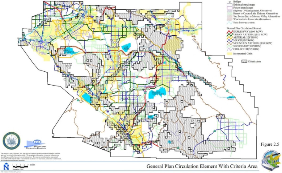
Approximately 5,840 acres of roadways will be improved/constructed within the Criteria Area.
State Route 79 Realignment (Newport Road to Gilman Springs Road)
The RCTC intends to designate right-of-way and construct an improved State Route 79 (SR-79) Transportation facility. Improvements to the portion of SR-79 south of Domenigoni Parkway are covered under the MSHCP as part of the proposed circulation element of the County General Plan.
Freeways
State freeways are also shown on Figure 2.4 they include I-215, I-15, I-10, SR-60, and SR-91. Freeways are operated and maintained by Caltrans. Caltrans has identified preliminary improvements for these facilities that have been included in the analysis as Covered Activities.
Interstate 215 Improvements
Interstate 215 is currently a 4-lane facility from the I-215 interchange to the San Jacinto River crossing, and a 6-lane facility from that point to the SR-60 interchange. Ultimate improvements include widening to 8 regular travel lanes, with 4 High Occupancy Vehicle (HOV) lanes and 2 auxiliary lanes from I-215 to SR-60. Additional improvements may include 75 feet of rail Corridor within the alignment.
Interstate 15 Improvements
Interstate 15 is currently an 8-lane facility from the San Diego County Line to the San Bernardino County Line. Improvements include addition of 4 HOV lanes and 2 auxiliary lanes, with an additional 75 feet of rail Corridor within the alignment.
Interstate 10 Improvements
Within the Plan Area, I-10 is an 8-lane facility. The ultimate improvements will result in the addition of 4 HOV lanes, 2 auxiliary lanes and a 75-foot wide rail Corridor.
State Route 60 Improvements
From the San Bernardino County line to the I-215 separation, SR-60 is currently a 6-lane facility. To the east of I-215, SR-60 is a 4-lane facility. Improvements will include widening the facility through the Plan Area to 8 lanes, with 4 additional HOV lanes, 2 auxiliary lanes and a 75-foot wide rail Corridor.
State Route 91 Improvements
SR-91 ranges from 6 to 12 lanes within the Plan Area, including HOV lanes from the Orange County line to Magnolia Street. Proposed improvements will include widening and lane reconfigurations that will result in 8 regular travel lanes, 4 HOV lanes and 2 auxiliary lanes, with an additional 75-foot wide rail Corridor.
Approximately 360 to 400 acres of freeways are proposed to occur within the Criteria Area.
In addition to the freeways listed, Caltrans maintains jurisdiction over other state highway facilities including: SR-74, SR-79, SR-371 and SR-71
CETAP Corridors
Four CETAP transportation Corridors, as discussed in Section 2.2 of this Nexus Report are proposed to be located within the MSHCP Plan Area: (1) a north-south CETAP transportation Corridor from Winchester to Temecula (the "WT Corridor"), (2) an east-west transportation Corridor from Hemet to Corona/Lake Elsinore (the "HCLE Corridor"), (3) the San Bernardino to Moreno Valley Corridor ("SBMV Corridor") and (4) a Corridor linking Orange County and Riverside County ("OCRC Corridor). Multiple alternatives for these Corridors are currently being contemplated; however, only one east-west Corridor, one north-south Corridor, one SBMV Corridor, and one OCRC County Corridor will be selected and built.
Winchester to Temecula (WT Corridor)
Two north-south CETAP alternatives for the WT Corridor have been selected for further analysis, with one of the alternatives including two options for a total of three different alignments. The northern terminus of both alternatives is located at Domenigoni Parkway and Winchester Road and the Southern terminus is at I-215. As previously stated, only one north-south Corridor will ultimately be constructed and covered under the MSHCP.
Depending upon which WT Corridor alternative is ultimately constructed approximately 10-130 acres within the Criteria Area will be impacted.
Hemet to Corona/Lake Elsinore (HCLE Corridor)
Two east-west CETAP alternatives for the HCLE Corridor with one alternative having two options, and the other alternative having three options, plus two hybrid options for a total of nine different alignments were selected for further analysis. The eastern terminus of one HCLE Corridor is located at Sanderson Avenue and Ramona Expressway with the western terminus being at I-15 and Cajalco Road. The eastern terminus of the other HCLE Corridor located at Domenigoni Parkway and Winchester Road.
San Bernardino to Moreno Valley Corrido (SBMV Corridor)
The San Bernardino to Moreno Valley Corridor will be located in the vicinity of I-215 and Ironwood Avenue, Riverside County and extend to California Street in San Bernardino County. This facility will tunnel under the Box Springs Conservation Area, with the tunnel portals sited outside of the Criteria Area.
This facility is covered under the MSHCP for direct, indirect and cumulative impacts within the MSHCP Plan Area. However, coverage is conditioned upon impacts outside of the MSHCP Plan Area being addressed. These include direct, indirect and cumulative impacts on the facility in San Bernardino County. An amendment to the MSHCP will be required to permit this facility within the MSHCP Conservation Area.
Orange County to Riverside County Corridor (OCRC Corridor)
A transportation Corridor linking Orange County with Riverside County is currently under study by RCTC and OCTA. The Corridor is not currently contemplated in the Draft General Plan Circulation Element, but is identified in the Draft EIR for the General Plan as a mitigation measure to reduce significant traffic impacts associated with the General Plan.
There are six alternative alignment/location concepts under study, however only one alignment alternative will be selected and ultimately constructed. The selected alignment would be considered a Covered Activity under the MSHCP, subject to the criteria and conditions contained therein. The MSHCP coverage applies only within the MSHCP Plan Area. In addition, it is acknowledged that if the selected alignment requires actions of the USFS, a separate FESA Section 7 consultation process between the USFS and the USFWS will be required.
The direct, indirect, cumulative and growth inducing impacts of the facility within the MSHCP Plan Area are addressed in the MSHCP. In addition, indirect, cumulative and growth inducing impacts for four of the corridor alterntives are considered to be addressed in the Orange County Central and Coastal Subregion NCCP, subject to satisfaction of the criteria contained in the MSHCP. This assumption is made because the Central and Coastal Subregion NCCP addresses buildout within its planning area and the four alternatives of the proposed facility are not anticipated to affect buildout assumptions within the NCCP planning area, as the primary impact of the facility would be on employment centers in the developed/non-conserved portions of the NCCP planning area.
The direct, indirect, cumulative and growth inducing impacts of the other two alternatives outside of the MSHCP Plan Area are not addressed, but are required to be addressed and mitigated through the proposed Orange County Southern Subregion NCCP. Approval of the Southern Subregion NCCP Plan is required as a condition of coverage for these two alternatives, as discussed in the MSHCP.
State Park Facilities
La Borde Canyon Off-Highway Vehicle Park/State Vehicle Recreation Area
An Off-Highway Vehicle Park/State Vehicle Recreation Area (SVRA) that may impact up to 1,200 acres including the active riding area, access roads, parking areas and other ancillary facilities may be constructed. The siting of the facilities must comply with the terms of the MSHCP.
Other State Park Facilities
Existing State Park facilities within the MSHCP Conservation Area include the Lake Perris State Recreation Area, Chino Hills State Park, Mount San Jacinto State Park, San Timoteo State Park and Anza-Borrego State Park. The following is a description of existing and future activities and acreages (including brush management areas) within these State Park facilities that are Covered Activities under the MSHCP. Recreational activities allowed within the campgrounds and day use areas include hiking, horseback riding, bicycling, camping, picnicking, swimming, boating and hunting (at Lake Perris SRA).
Lake Perris State Recreation Area
Existing visitor use facilities are primarily located along the north shore of the lake and on the south shore in the Bernasconi Pass area. The main administrative facility is located below the dam. Existing use areas consist of approximately 220 acres of campgrounds, 120 acres of parking areas, 200 acres of day use areas, 10 acres of administrative uses, 5 acres of water treatment and storage facilities, a 5-acre museum, 54 acres of roads and 10 acres of trails. Future uses/expansions of existing uses are anticipated to include a 2-acre visitor center, 15 additional acres of parking, a 15-acre swim lagoon, 1-acre campfire center, 7 additional acres of campgrounds, 1 additional acre of trails/bridges, and 4 additional acres of roads.
Chino Hills State Park
Existing improvements within portions of the Chino Hills State Park within the MSHCP Plan Area are limited to two acres of existing roads. Future improvements will include two acres of parking, and one acre of campgrounds.
Mount San Jacinto State Park and State Wilderness
This park facility includes 20 acres of campgrounds, 5 acres of parking areas, 10 acres of day use areas, 1 acre of administrative facilities, 1 acre of water facilities, 15 acres of roads and 9 acres of trails. Future improvements will include a two-acre visitor center, 5 additional acres of parking, 15 additional acres of campgrounds, 2 additional acres of trails, and two additional acres of roads.
San Timoteo Park
Land is currently being acquired to establish a State Park. Existing improvements to the land include an acre of administrative facilities and 8 acres of roads. Future improvements include a 2-acre visitor center, 5 acres of parking areas, 15 acres of campgrounds, 2 acres of trails, and 2 additional acres of roads.
Anza-Borrego State Park
This facility has 5 acres of administrative uses, 18 acres of roads, and 5 acres of trails within the MSHCP Plan Area. No future uses are proposed.
Flood Control Facilities
Flood control facilities within the Criteria Area undertaken by a Permittee are Covered Activities. These facilities include those identified in Table 2-7 as well as facilities that are located outside of the Criteria Area are also Covered Activities.
San Jacinto River Flood Control Project
The Riverside County Flood Control and Water Conservation District ("RCFCWCD") anticipates the Development of a flood control project, in the San Jacinto River area. Other Covered Activities within the vicinity of the San Jacinto River include: Ramona Expressway bridge and culvert, Nuevo Road bridge, San Jacinto Avenue crossing, I-215 bridge and levee, Case Road bridge, Burlington Northern Santa Fe Railroad bridge, Goetz Road bridge, Ethanac Road bridge, Perris Valley Storm Drain Channel and Romoland Channel. The Development of the aforementioned flood control facilities will facilitate planned Development within portions of the MSHCP Plan Area.
Future Facilities
Future facilities i.e., facilities necessary to support planned Development that are carried out by a Permittee, Participating Special Entities and/or Third Parties Granted Take Authorization will be considered Covered Activities.
There are four general categories of future facilities that are linear, or involve engineering constraints that make avoidance of Criteria Areas not practicable. These categories are: water/wastewater facilities, electrical utility facilities, natural gas facilities, and waste management facilities.
2.4. MSHCP CONSERVATION AREA ASSEMBLY
Funding for local acquisition of Additional Conservation Area Lands (53,546 acres), will be provided through the local funding program, which is discussed in Section 5 of the Nexus Report. Figure 2.6 and Table 2-8 summarizes the expected acquisition sources of the Additional Conservation Area Lands.
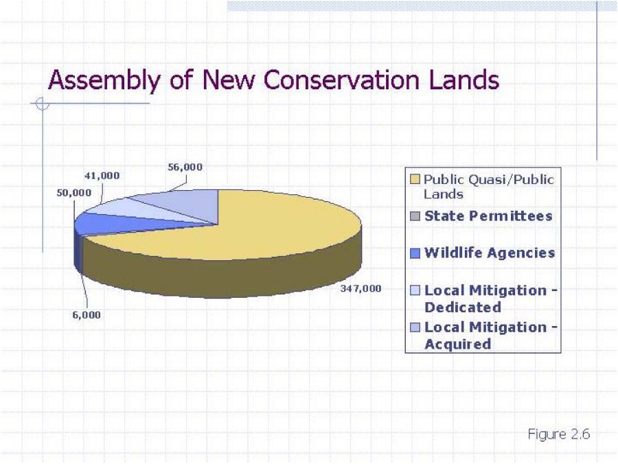
The Local Implementation Plan provides for the assembly of 103,000 acres of Additional Conservation Area Lands which are identified as New Conservation Counted as Mitigation in Table 2-8 above. The Local Implementation Plan utilizes the HANS Process35 as the primary mechanism for implementing the MSHCP. The local assembly of Additional Conservation Area Lands will occur under HANS using either the general approach of dedications of land provided through the Cities' and County's Development Review process for new Development and/or through the application of incentives, using the approach of the acquisition of lands from willing sellers, or a combination of the two approaches.
The Local Implementation Plan has four approaches that will be assist in obtaining conservation lands: Development Review, Local Permittees' Acquisition of Additional Conservation Area Lands, Caltrans Acquisition of Additional Conservation Area Lands, and State Parks Acquisition. Table 2-9 presents the anticipated results of the four implementation approaches, which are discussed in the following paragraphs.
2.4.1 DEVELOPMENT REVIEW
In the course of the Development review process, approximately 41,000 acres of land are anticipated to be conserved as Additional Conservation Area Lands through: (1) Density Bonus/Clustering in Rural and Open Space Lands; (2) Density Transfers and Bonuses, Historic Open Space Dedications in Community Development Areas; (3) Wetlands Conservation.
2.4.2 LOCAL PERMITTEES' ACQUISITION OF ADDITIONAL CONSERVATION LANDS
Approximately 56,000 acres will be conserved either through direct acquisition from willing sellers or through the purchase of conservation easements or other mechanism that results in the permanent Conservation of the lands. The HANS process will identify properties to be acquired on a first-in-first-out basis as funding becomes available. Acquisitions may also occur outside of the HANS process as opportunities arise to conserve important properties that will benefit the MSHCP Conservation Area. Acquisitions may be used to fill in critical gaps in the MSHCP Conservation Area and strategically consolidate holdings in an area to allow the conservation value of previously conserved properties to be fully realized.
2.4.3 CALTRANS ACQUISITION OF ADDITIONAL CONSERVATION LANDS
Within the first eight years of Caltrans' Permit, it will acquire two Additional Conservation Area Land areas, one of approximately 2,000 acres in the eastern portion of the Criteria Area and one of approximately 1,000 acres in the western portion of the Criteria Area. The estimate for the acquisition costs of these lands is $36 million. The estimated cost for establishing the western area, based on $20,000 per acre, is $20 million. The estimated cost for the eastern area is $16 million based on $8,000 per acre. The estimated cost per acre for both areas is considered a mid-range cost per acre and reflects the per acre costs of recent acquisitions and/or appraisals funded by the Wildlife Conservation Board, the land acquisition arm of CDFG.
2.4.4 STATE PARKS ACQUISITION OF ADDITIONAL CONSERVATION LANDS
State Parks are obligated to fulfill the purpose of the Permits, MSHCP and IA for covered activities and to comply with certain policies as set forth in Volume I of the Draft MSHCP. State Parks will serve as a member of the Conservation Area Management Oversight Committee and carry out all other applicable requirements of the MSHCP, the IA and the Permits. Prior to construction of the OHV Park, State Parks will contribute 3,000 acres of Additional Conservation Lands in the Badlands, within the Criteria Area, as mitigation for impacts associated with up to 600 acres of active riding areas resulting from the establishment of a State Vehicular Recreational Area in the Badlands. For Non-OHV activities, State Parks' Take Authorization for Covered Activities is contingent on the preparation of unit management plans pertaining to each Covered Activity, which will reflect the scope of work and obligation of State Parks to manage and monitor State Parks land within the MSHCP Conservation Area.
2.5. RELATIONSHIPS AND DIFFERENCES BETWEEN RCIP COMPONENTS
The General Plan Circulation Element includes proposed CETAP corridors as part of its roadway and highway system. The MSHCP provides comprehensive mitigation for the project specific cumulative, and indirect impacts resulting from Development of the proposed General Plan land uses and transportation facilities (including CETAP corridors) within the western portion of the County. The MSHCP also includes CETAP corridors as permitted activities where they cross the MSHCP Conservation Area.
The three components of RCIP cover different areas of the County. The General Plan, which contains a circulation element that provides for internal transportation facilities, covers all unincorporated lands within Riverside County's corporate boundary except March Air Conservation Area Base, Indian lands, and lands owned by the State and federal governments. The MSHCP covers both unincorporated and incorporated areas in western Riverside County, since the Cities are participating in the program. CETAP addresses specific transportation corridors in western Riverside County.
Due to the differences in each RCIP component, the individual components require approval from different government entities. The General Plan was prepared pursuant to the provisions of the California Government Code and requires approval only by the County of Riverside, although certain actions undertaken pursuant to the General Plan may require approvals of outside agencies. Environmental documentation for the proposed General Plan is conducted under CEQA.
The MSHCP is being prepared pursuant to both State and federal law and will require approval of the County, the Cities, CDFG, and the USFWS. Since the MSHCP complies with State and federal law, its environmental documentation is subject to the provisions of CEQA and NEPA. Lead Agencies for CEQA and NEPA purposes are Riverside County and USFWS, respectively.
CETAP proposes using local, State, and federal sources to fund right-of-way acquisition and ultimate construction of its corridors. Thus, environmental documentation for CETAP must also comply with the provisions of CEQA and NEPA. The lead agencies for CEQA and NEPA purposes are Riverside County and the Federal Highway Administration, respectively.
3. EXISTING ENVIRONMENTAL, TRANSPORTATION, AND BIOLOGICAL SETTING OF THE MSHCP PLAN AREA
3.1. ENVIRONMENTAL SETTING
Variation in topography, soil, and climate across the elevational range of the MSHCP creates habitats for a wide variety of animals and plants, including many that are rare or endemic to Southern California. Thirty-nine species indigenous to western Riverside County have special status under FESA and/or CESA. These include species that are listed as "endangered" or "threatened" under FESA or that have been "proposed" or are "strong candidates" for such listing.
3.2. TRANSPORTATION SETTING
The existing circulation and transportation system serving the proposed MSHCP Plan Area consists of a series of separate modes of travel and goods movement that include passenger vehicles and truck freight, transit, passenger and freight rail, passenger and cargo air, non-motorized systems (bicycle facilities, pedestrian facilities, and equestrian facilities) and major utility corridors. Roadways in the Plan Area include numerous State highways, County roads, and city routes. The public transit system includes fixed route public transit systems, common bus carriers, AMTRAK (intercity rail service), MetroLink (commuter rail service), and other local agency transit and paratransit services. Transportation systems in the Plan Area include general aviation facilities, limited passenger air service within the proposed Plan Area, extensive air passenger facilities in the Southern California and San Diego regions, freight rail service, bicycle facilities, and other non-motorized forms of transportation (pedestrian and equestrian trails).
Travel occurs within the Plan Area and between the Plan Area and Los Angeles, Orange, Ventura, San Bernardino, San Diego, Imperial and Kern Counties as residents and businesses from Riverside County commute to places of employment and economic activity. There is also travel between the western and eastern portions of the County (i.e., between Riverside and Blythe). Due to the interrelationship of employment, housing and services, and the low average density of existing land uses, the private automobile is the
dominant mode of travel within the proposed Plan Area, with transit representing less than two percent of all trips made in the County. Public transportation, where service is available, is utilized primarily by a transit-dependent population (senior citizens, students, low-income residents, and the physically disabled) that generally does not have access to automobiles. The Plan Area's industrial and agricultural economies depend on safe and efficient movement of goods and people. The County maintains an extensive network of low volume rural roads in sparsely settled areas to service goods movement and the agricultural industry. Large trucks are the primary means of transporting such goods. Freight rail is also an important element in movement of goods in the Plan Area. Non-motorized transportation is also prevalent in the proposed Plan Area and includes bikeways, pedestrian facilities, and equestrian amenities.
3.2.1 EXISTING STREET AND HIGHWAY SYSTEM
Figure 3.1 illustrates the existing roadway system in the Plan Area. The proposed Plan Area's highway network, includes three interstate routes (I-10, I-15, and I-215) and several State Routes (SRs 60, 71, 74, 79, 91, 243, and 371).
The highway system also includes County roadways, as well as roadways within each of the Cities. Major roadways include Alessandro Boulevard, Arlington, La Sierra, Limonite, and Magnolia Avenues, Market Street, Mission Boulevard, Perris Boulevard, Ramona Expressway, Rancho California Road, San Jacinto Road, Van Buren Boulevard, and Washington Street.
SR-60 (Pomona Freeway), I-10 (San Bernardino Freeway), SR-91 (Riverside Freeway), and SR-74 (Ortega Highway) link the Plan Area to Los Angeles and Orange Counties. The I-15 freeway and minor conventional highways provide links to San Diego County its many tourist and recreational amenities, and to Mexico via I-5, I-15, and I-805. Links to San Bernardino County are provided by I-15 and I-215, as well as by other major and minor local roadways
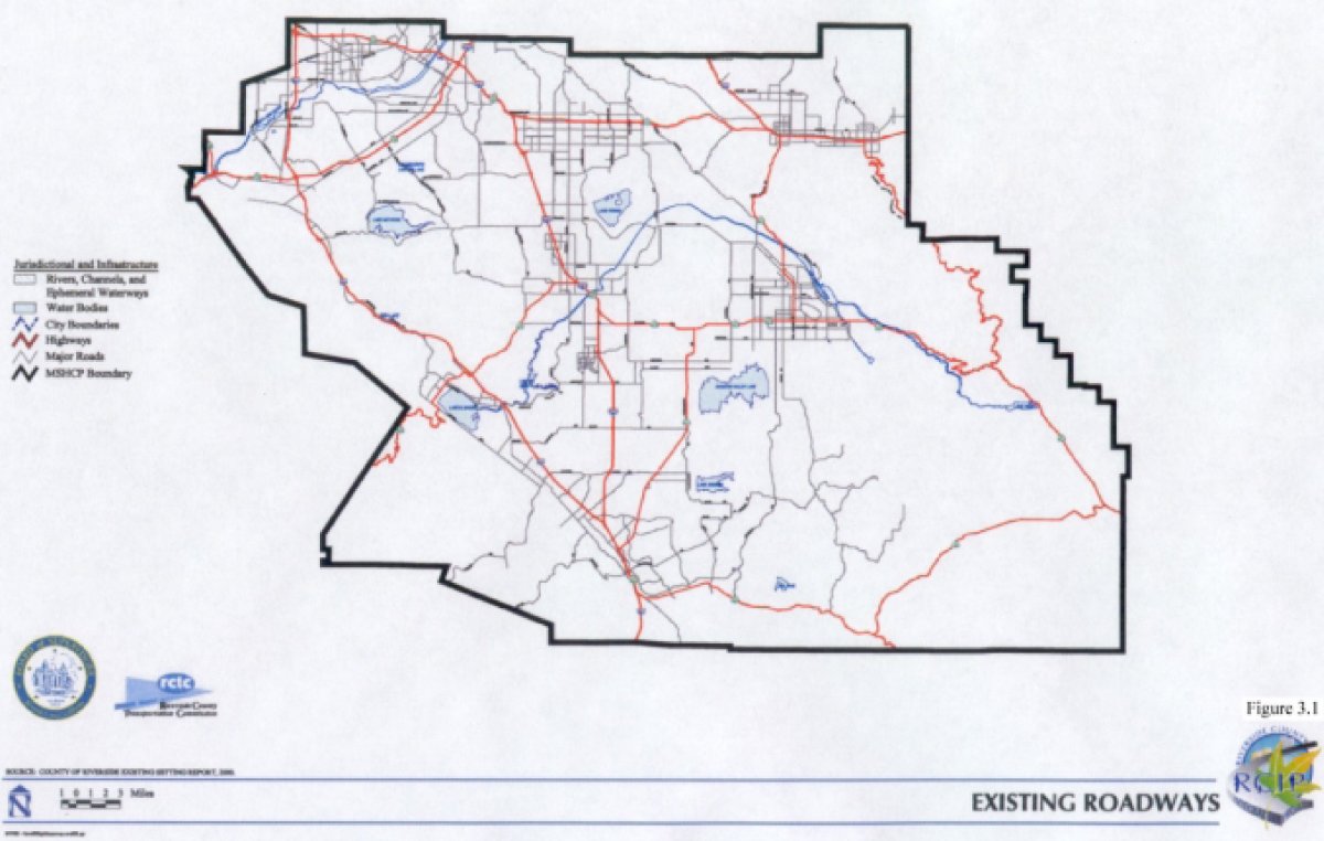
The I-10 freeway also provides connection to destinations in Arizona, with I-15 and I-215 providing access through San Bernardino County to Nevada and its primary recreation areas in the City of Las Vegas and Lake Mead. In addition, I-15 provides access south to San Diego.
3.3. BIOLOGICAL SETTING
This section describes the biological setting in which the goal of assembling the MSHCP Conservation Area, which will conserve over 100 plant and wildlife species would be achieved. The reader is referred to Volume II of the MSHCP36 for a detailed discussion of the plants and wildlife in the Plan Area.
3.3.1 BIOREGIONS
The Plan Area encompasses seven distinct bioregions:
These bioregions are depicted on Figure 3.2 and described below.
Santa Ana Mountains Bioregion
The Santa Ana Mountains Bioregion extends south of State Route 91 (SR-91) to the Riverside/San Diego County line and occurs west of Interstate 15 (I-15). It encompasses the Cleveland National Forest and areas north of the Santa Margarita River.
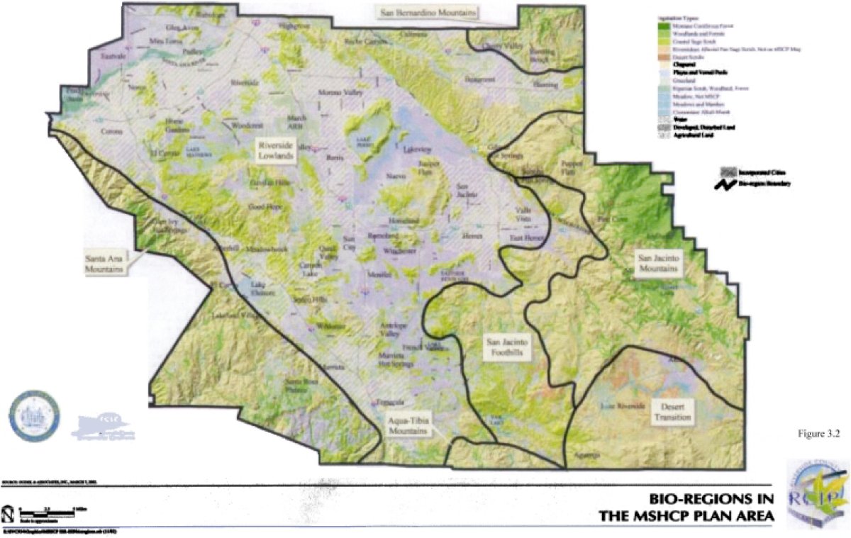
This bioregion generally occurs at elevations above 2,000 feet and supports Diegan coastal sage scrub, mesic chaparral, and sparse coniferous vegetation.
Riverside Lowlands Bioregion
The Riverside Lowlands Bioregion is the largest bioregion in the Plan Area and is located east of the Santa Ana Mountains Bioregion, south of the Riverside/San Bernardino County line, west of Diamond Valley Lake, Lake Skinner, and Gilman Hot Springs, and north of the Riverside/San Diego County line. This bioregion encompasses Estelle Mountain, Lake Mathews, Reche Canyon/Badlands, the San Jacinto Valley, Gavilan Hills, Lakeview Mountains, and French Valley. The Riverside Lowlands Bioregion generally occurs at elevations below 2,000 feet and is characterized by Riversidean sage scrub and annual grasslands. The relatively arid climate is in part the result of the rain shadow effect cast by the Santa Ana Mountains. A high level of disturbance and urbanization is noted within this bioregion.
San Jacinto Foothills Bioregion
The San Jacinto Foothills Bioregion generally includes areas north of SR-79, east of the Riverside Lowlands Bioregion and west of the San Jacinto Mountains Bioregion. This bioregion encompasses Vail Lake, Sage, and Cactus Valley. The San Jacinto Foothills Bioregion occurs at elevations of 2,000 to 3,000 feet and is dominated by Riversidean sage scrub and xeric chaparral associations. This bioregion receives less frequent frost and snow than the mountainous areas and has not been heavily disturbed or urbanized.
Agua Tibia Mountains Bioregion
The Agua Tibia Mountains Bioregion extends south from SR-79 to the Riverside/San Diego County line. It encompasses the Agua Tibia Mountains and generally occurs at elevations above 2,000 feet. This bioregion supports Diegan coastal sage scrub, mesic chaparral, and sparse coniferous vegetation and has not been heavily disturbed or urbanized.
Desert Transition Bioregion
The Desert Transition Bioregion is located in the southeastern portion of the Plan Area and encompasses the Cahuilla Indian Reservation and Lake Riverside areas. The Desert Transition Bioregion generally occurs at elevations above 3,000 feet, is arid and desert-influenced, and supports red shank chaparral, big basin sage scrub, and semidesert succulent scrub habitats. This bioregion has not been heavily disturbed or urbanized.
San Bernardino Mountains Bioregion
The San Bernardino Mountains Bioregion generally occurs at elevations above 3,000 feet and encompasses areas north of I-10 within the Calimesa, Beaumont, and Banning area. This bioregion supports coniferous forests, montane chaparral, and broad-leaved forest. The San Bernardino Mountains Bioregion is floristically distinct from the San Jacinto Mountains Bioregion and has not been heavily disturbed or urbanized.
San Jacinto Mountains Bioregion
The San Jacinto Mountains Bioregion generally occurs at elevations above 3,000 feet and encompasses the San Bernardino National Forest, Pine Cove, Idyllwild, and upper San Jacinto River and Bautista Canyon Creek. This bioregion supports coniferous forests, montane chaparral, and broad-leaved forest. The San Jacinto Mountains Bioregion is floristically distinct from the San Bernardino Bioregion.
3.3.2 VEGETATION COMMUNITIES
The MSHCP Plan Area supports the following vegetation communities:
In addition to the communities listed above, the Plan Area also contains agricultural, and developed land. A brief description of each vegetation community is provided below.37
Agriculture
Agricultural lands include areas occupied by dairies and livestock feed yards or areas that have been tilled for use as croplands or groves/orchards. The largest areas of dairy and livestock feed yards are located north of San Jacinto and north of Juniper Flats in the communities of Lakeview, Mystic Lake, Nuevo, southeast Perris, Eastvale, Lake Norconian off Bellegrave Avenue, Norco, and in Glen Avon. Field croplands are mapped extensively throughout the Plan Area with the largest areas located around the following: State Route 371 (SR-371) in the vicinity of Anza; in an east-west strip from Murrieta Hot Springs, through French Valley; Antelope Valley, Paloma Valley, Menifee Valley, Winchester, and Domenigoni Valley to West Hemet; the Diamond Valley area; and in Eastvale. The largest grove/orchard area is in Santa Rosa East between Gavilan Mountain and Mesa de Colorado.
Chaparral
Chaparral vegetation is the most abundant and widespread vegetation type in western Riverside County. Within the Plan Area large contiguous stands of chaparral occur along the Santa Ana Mountains in the west along the San Bernardino, San Jacinto, and Agua Tibia Mountains in the east and south. Although chaparral is less common than other vegetation types in the central lowlands of Riverside County, three large chaparral-dominated areas occur on steeper lands near the Gavilan Hills-Gavilan Plateau-Meadowbrook Region, the Lakeview Mountains-Double Butte area, and the Sedco Hills-Hogbacks area.
Cismontane Alkali Marsh
Cismontane occupies in two general localities in the Plan Area, along Cahuilla Creek south of Anza and upstream from Lake Mathews along the Colorado River aqueduct.
Coastal Sage Scrub
Coastal sage scrub is distributed throughout western Riverside County and the Plan Area. It occurs from the eastern slopes of the Santa Ana Mountains to elevations in the San Jacinto Mountains less than 5,000 feet. Sage scrub often is distributed in patches throughout its range. Over a scale of several miles, it can be found in diverse vegetation community mosaics with other plant communities, particularly grassland and chaparral, and oak/riparian woodland in wetter areas. In western Riverside County, coastal sage scrub is found both in large contiguous blocks scattered throughout the County as well as integrated with chaparral and grasslands.
Desert Scrub
Desert scrub, including big sagebrush scrub and Sonoran desert scrub, occurs mostly in the southeastern portion of western Riverside County. Large acreages of this vegetation community occur north and south of SR-371 within Tule Valley, Culp Valley, Wilson Creek, Cahuilla, the Ramona Indian Reservation, the Community of Anza, and east of Aguanga and Lake Riverside.
Grasslands
Grasslands occur throughout most of western Riverside County. Two general types of grasslands occur in Southern California: (1) non-native dominated, primarily annual grassland ("non-native grassland") and (2) native dominated, perennial grassland ("valley and foothill grassland"). Valley and foothill grasslands expected within the Plan Area are located on the Santa Rosa Plateau. Non-native grasslands occur throughout the majority of the proposed Plan Area, usually within close proximity to urbanized or agricultural land uses. Large patches of non-native grasslands occur in the Riverside Lowlands near March Air Conservation Area Base (ARB), Lake Mathews, Lake Perris, Lake Elsinore, near Banning, Cahuilla, and in the Terwilliger Valley south of Anza.
Meadows and Marshes
Meadow and marsh vegetation communities, including coastal and valley freshwater marsh, undifferentiated marsh, and wet montane meadow, exist within the Plan Area. Occurrences of this vegetation community have been mapped in the Prado Basin in the Santa Ana River Valley, on the Santa Ana River near Pedley, north of Lake Elsinore in Walker Canyon, near San Jacinto, along the shores of Lake Skinner and Vail Lake, and adjacent to the cismontane alkali marsh on Cahuilla Creek. Undifferentiated marsh was mapped in three locations, including the shore of Lake Mathews, near Mystic Lake, and upstream from Vail Lake along Temecula Creek in the Aguanga Valley. Wet montane meadow was mapped in the San Jacinto Mountains in the San Bernardino National Forest, primarily within the vicinity of Hemet Lake.
Montane Coniferous Forest
Montane coniferous forest, including Jeffrey pine, lodgepole pine forest, lower montane coniferous forest, mixed evergreen forest, Southern California white fir forest, and subalpine coniferous forest. It occurs within the San Jacinto Mountains, Agua Tibia, Cleveland National Forest, and Santa Rosa Mountains.
Playas and Vernal Pools38
These vegetation communities are found in the San Jacinto Valley/Perris Basin and on the Santa Rosa Plateau.
Riparian Forest, Woodland, and Scrub
Riparian vegetation, including forest, woodland, and scrub subtypes, is distributed in waterways and drainages throughout much of western Riverside County. Southern cottonwood/willow forest makes up the largest proportion of the riparian vegetation in the Plan Area, and occurs primarily along the Santa Ana River drainage from Lake Evans to beyond the Prado basin and along the San Gorgonio River north of Banning and along Temecula Creek east of Vail Lake. Additional types of riparian vegetation can be found along the San Gorgonio River north of Banning (montane riparian forest), Temescal Canyon Wash and its tributaries (riparian scrub and mule fat scrub), the stream channels within the San Mateo Canyon watershed (riparian forest, southern sycamore/alderriparian woodland and riparian scrub), and Vail Lake (tamarisk scrub).
Riversidean Alluvial Fan Sage Scrub
Riversidean alluvial fan sage scrub occurs throughout many drainages in the Plan Area. Much of this vegetation occurs on the Santa Ana River near Lake Evans in the City of Riverside; along the San Gorgonio River and tributaries near Banning; on the San Jacinto River from the National Forest to the Soboba Indian Reservation; near Temecula along Temecula Creek; the Aguanga area; Bautista Creek south of Hemet; and near Murrieta and Glen Ivy in the Temescal Valley.
Open Water39
The Plan Area contains open water habitat at Vail Lake, Lake Skinner, Diamond Valley Lake, Lake Perris, Mystic Lake, Canyon Lake, Lake Elsinore, Lee Lake, Lake Mathews, Hemet Lake, portions of the San Jacinto River, portions of the Santa Ana River, and various small ponds, private reservoirs, and portions of stream channels.
Woodlands and Forests
The Plan Area supports Woodlands and forests, which consist of black oak forest, broad-leaved upland forest, oak woodland, and peninsular juniper woodland vegetation communities are known to occur throughout the Plan Area. This vegetation community can occur on stream sides, canyon bottoms, and flat to very steep topography.
4. MITIGATION FEE JUSTIFICATION
4.1. HISTORICAL CONTEXT FOR MITIGATION FEES
Prior to World War II, development in California was held responsible for very little of the cost of public infrastructure. Public improvements were financed primarily with general funds and utility charges. It was not uncommon during this period for speculators to subdivide tracts of land without providing any public improvements, expecting the closest city to eventually extend to the project and provide public improvements and services.
However, starting in the late 1940s, the use of impact fees grew with the increased planning and regulation of new development. During the 1960s and 1970s, California courts broadened the right of local government to impose fees on developers for public improvements that were not located on project sites. More recently, with the passage of Proposition 13, the limits on general revenues for new infrastructure has resulted in new development being held responsible for a greater share of public improvements, and both the use and levels of impact fees have grown substantially. This greater level of fees was undoubtedly driven in part by a need to offset the decline in funds for infrastructure development from other sources.
The levy of impact fees is one authorized method of financing the public facilities necessary to mitigate the impacts of new development for an increased population. A Fee is "a monetary exaction, other than a tax or special assessment, which is charged by a local agency to the applicant in connection with approval of a development project for the purpose of defraying all or a portion of the cost of public facilities related to the development project..." 40 A fee may be levied for each type of capital improvement required for new development, with the payment of the fee occurring prior to the beginning of construction of a dwelling unit or retail/non-retail building (or prior to the expansion of existing buildings of these types). Fees are often levied at final map recordation, issuance of a certificate of occupancy, or more commonly, at building permit issuance.
4.2. REQUIREMENTS TO ESTABLISH A DEVELOPMENT IMPACT MITIGATION FEE
Assembly Bill ("AB") 1600, which created Section 66000 et seq. of the Government Code, was enacted by the State of California in 1987. Section 66000, also called the Mitigation Fee Act, requires that all public agencies satisfy the following requirements when establishing, increasing or imposing a fee as a condition of new development:
- Identify the purpose of the fee. (Government Code Section 66001(a)(1))
- Identify the use to which the fee will be put. (Government Code Section 66001(a)(2))
- Determine that there is a reasonable relationship between the fee's use and the type of development on which the fee is to be imposed. (Government Code Section 66001(a)(3))
- Determine how there is a reasonable relationship between the need for the public facility and the type of development project on which the fee is to be imposed. (Government Code Section 66001(a)(4))
- Discuss how there is a reasonable relationship between the amount of the fee and the cost of the public facility or portion of the public facility attributable to the development on which the fee is imposed.
Identifying these items will help a fee to meet the nexus and rough proportionality requirements of the Mitigation Fee Act and other requirements of state and federal law.
This section of the Mitigation Fee Nexus Report has been prepared to satisfy the requirements of the Mitigation Fee Act and establish a rational and substantial nexus between new development in the MSHCP Plan Area and the imposition of a Local Development Mitigation Fee ("LDMF").
4.3. THE FEE AS ONE COMPONENT OF THE OVERALL FINANCING PROGRAM
As discussed in Section 5, funding is an essential component of the MSHCP and will be used to mitigate the effects of public and private Development projects that will be facilitated by the MSHCP. Funding for the MSHCP will come from federal, State, and local sources. State funding will mitigate the effects of State projects by State permit holders in proportion to their impacts within the Plan Area. Caltrans and the State Department of Parks and Recreation are State Permittees under the MSHCP with specific projects included as Covered Activities as discussed in Section 2.3.7.
Of the 153,000 acres of Habitat to be conserved by implementation of the MSHCP (Figure 4.1), state and federal acquisition and mitigation for State Permittees will account for 56,000 acres or approximately 37% of the Additional Conservation Area Lands. Local Permittees are responsible for the remaining 97,000 acres with Local Development Review Processes expected to contribute 41,000 acres to the Conservation Area Assembly and the remaining 56,000 acres being acquired (i.e. purchased).
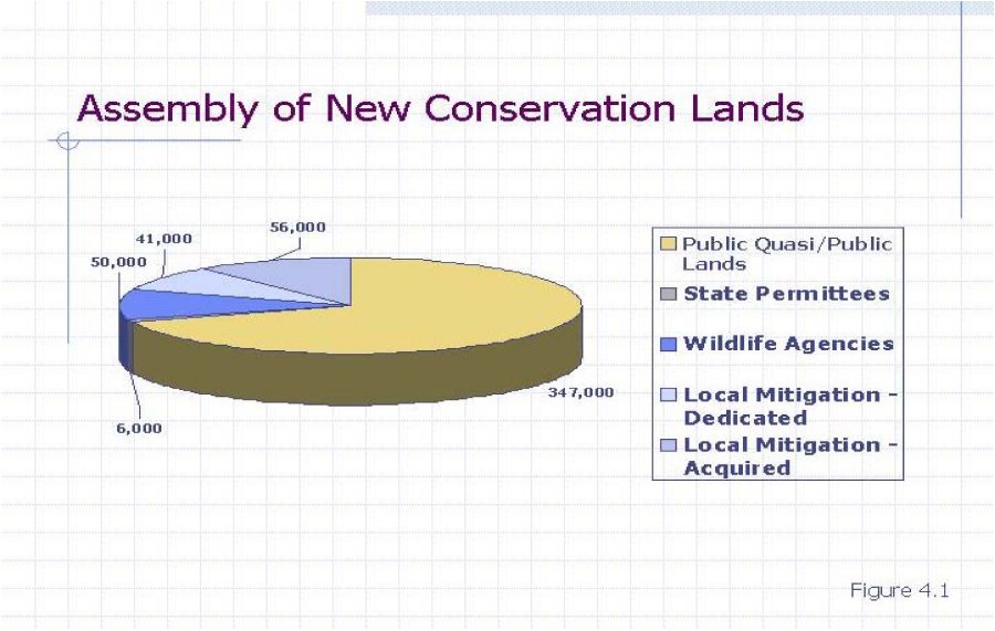
The main funding source for these local acquisitions is the imposition and collection of the LDMF by the County and participating Cities.
In addition to land acquisition for Conservation purposes, other local program costs (which are discussed in Section 5 of the Nexus Report) include: management, monitoring, adaptive management, and administration. It is important to note that the mitigation fee will be used only for Habitat acquisition and other appropriate uses. No LDMF monies will be used for management, monitoring, or adaptive management activities. Local funding sources that may be used for management, adaptive management, and monitoring include: mitigation for regional infrastructure, landfill tipping fees, and other potential new revenue sources as discussed in Section 5.
4.4. PURPOSE OF THE FEE (GOVERNMENT CODE SECTION 66001(A)(1))
The Hearing Draft General Plan designates a total of 179,940 acres for community development land uses, 294,900 acres for rural land uses, 439,530 acres for open space land uses, and 30,610 acres for agricultural land uses within unincorporated County lands in the MSHCP Plan Area41 . According to the General Plans of the cities, a total of 222,530 acres would be designated for community development, 12,190 acres for rural use, 29,840 acres for open space, and 7,670 acres for agriculture.42 As Development occurs within western Riverside County, land that would otherwise remain in an open space or undeveloped state will become developed.
At build out, approximately 491,300 acres of currently vacant and agricultural lands are anticipated to shift to community development/rural uses to accommodate projected growth within the Plan Area. The majority of the last remaining intact Habitat is owned by public agencies and private landowners, who are required to mitigate the loss or degradation of this Habitat in order to develop their respective lands.
The LDMF is to be charged throughout the Plan Area to all future development within the western part of the County and the Cities in order to provide a coordinated conservation area and implementation program that will facilitate the preservation of biological diversity, as well as, maintain the region's quality of life. The reason for the imposition of the Fee over the entire region is that the loss of habitat for endangered species is a regional problem resulting from the cumulative impacts of continuing development throughout all of the Jurisdictions. In fact, biologists have identified most of Western Riverside County as belonging to its own separate "South Coast Bio-Region," with its own diverse plant and animal life, of which numerous animal species and narrow endemic plants have been granted special status under FESA and/or CESA.
As noted in the Public Hearing Draft General Plan and the MSHCP itself, the MSHCP was specifically designed to cover a large geographical area so that it would protect numerous endangered species and habitats throughout the region:
"The [Western Riverside County MSHCP Program] plan is the largest HCP ever attempted and covers multiple species and multiple habitats within multiple jurisdictions. The plan covers a diverse landscape from urban cities to undeveloped foothills and mountain forests. In addition to the presence of multiple habitats, the plan stretches across the Santa Ana Mountains, Riverside Lowlands, San Jacinto Foothills, San Jacinto Mountains, Aqua Tibia Mountains, Desert Transition and San Bernardino Mountains bio-regions."43
It is the projected cumulative effect of future development that has required the preparation and implementation of the MSHCP to protect multiple habitats and multiple endangered species. Each development will contribute to the need for new regional infrastructure which, in turn, will adversely affect species and habitats. Without future development, existing habitat would not be in danger of permanently disappearing, and those endangered species currently residing within that habitat could be sustained. Even future development projects that may not be located on property that is suitable for habitat purposes contribute to impacts on species because they are an interactive component of a much greater universe of development located throughout the Plan Area. First, the property owners and/or the tenants associated with any potentially non-habitat development regularly utilize and benefit from public roads, flood control facilities and other regional infrastructure, some of which are located on properties that are suitable for habitat purposes. Second, these property owners and tenants are dependent on and, in fact, may not have chosen to utilize their development, except for residential, retail, employment and recreational opportunities located nearby on other existing and future development, some of which has been or will be located on sites that constitute suitable habitat. Third, the availability of residents, employees and customers from this non-habitat development has a growth-inducing impact without which some of the development on habitat properties would not have occurred. As a result, all development projects within the region contribute to the cumulative impacts of development that constitute one of the primary reasons for the disappearance of suitable habitat for endangered species throughout the region. In addition, the purchase of habitat properties for preservation purposes with regionally-generated fees not only mitigates the endangered species habitat issue, but also helps resolve other regional problems related to the retention of open space and historic viewsheds which, in turn, promote flood protection and water re-charge measures.
Furthermore, it is the very nature of a habitat conservation plan that requires a regional solution. The concept of purchasing small, unattached piecemeal properties located throughout the Jurisdictions in order to provide habitat located near to every development project would not be conducive to the survival of most endangered species. As documented in the MSHCP, it is a basic principal of Conservation Biology that "Large Habitat Blocks" be conserved and that these blocks and other Conservation Area areas must be contiguous and connected. Considerable empirical evidence is cited in the MSHCP regarding the importance of "wildlife movement corridors and Habitat Linkages between core Habitat areas." In fact, the MSHCP notes "connectedness through landscape Linkages and movement corridors are important because Habitat fragmentation and isolation lead to extinction of local populations and are the most serious threats to biological diversity."44 Only by accruing financial resources such as impact fees on a regional-wide basis and utilizing these monies to purchase those critical sites throughout the region that are best suited (or most appropriately priced) for habitat purposes can the region's endangered species be best protected with the limited funding sources available.
The LDMF provides funding to mitigate the direct, indirect, and cumulative impacts to Habitat associated with the construction, operation, and maintenance of certain transportation facilities needed to serve future planned development within the Plan Area. As stated in Section 1, the population in western Riverside County will increase by almost 100% in the next 20 years. As a result of increased population, new homes, roads, and other public infrastructure (i.e. utilities, park facilities, etc.) must be constructed in a timely manner if Future Development is to proceed in an orderly, efficient and cost effective fashion. One of the purposes of the LDMF is to provide mitigation to offset impacts caused by new regional infrastructure necessitated by all new Development in the Plan Area. The Incidental Take permit associated with the MSHCP and the Covered Activities discussed in Section 2.3.7 will permit the construction of the public infrastructure and private projects needed to serve future development resulting from the population growth projected in the Plan Area.
The LDMF and MSHCP will ensure habitat conservation and species protection on a basis not experienced before in western Riverside County. This level of protection provides an unprecedented level of development certainty to the County, participating Cities, state and federal wildlife agencies; development, agriculture, and environmental communities; and the public at large.
The LDMF will reduce the need to list additional species in the future by funding the assembly of a regional conservation system to promote the biological viability and recovery of Western Riverside County's ecosystems, Habitats, and the species dependent thereupon. The comprehensive scope of the MSHCP provides a means to coordinate, standardize, streamline, and ensure closure regarding the mitigation requirements of FESA, CESA, NEPA, CEQA, and the NCCP Act within the Plan Area.
The overall goal of the MSHCP is to enhance and maintain biological diversity and ecosystem processes while allowing future economic growth in western Riverside County. This goal is based on goals and principles stated in a Planning Agreement that was drafted between the Wildlife Agencies and participating local entities. Specifically, Section 3 of the Planning Agreement includes the following goals and principles for development of the MSHCP:
The MSHCP provides for actions that will minimize the decline of Covered Species within the Plan Area. This is reflected in the Biological Goal for each of the Covered Species to "Conserve Covered Species and their Habitats", with Conservation defined as:
"To use, and the use of, methods and procedures within the MSHCP Conservation Area and within the Plan Area as set forth in the MSHCP Plan, that are necessary to bring any listed species to the point at which the measures provided pursuant to FESA and the California Fish and Game Code are no longer necessary. However, Permittees will have no duty to enhance, restore or revegetate MSHCP Conservation Area lands unless required by the MSHCP Plan or agreed to through implementation of the Plan."
The LDMF, by funding regional habitat planning and conservation of habitat in functional blocks as opposed to the current process of piecemeal ad hoc conservation, will minimize, if not eliminate, the uncoordinated preservation of scattered habitat areas set aside as mitigation for individual project impacts. This will eliminate the traditional project-by-project habitat/species mitigation process for resolving conflicts between species preservation and development in advance, thus allowing future Development to proceed in an orderly, efficient and cost effective manner. The MSHCP, by addressing the requirements of the State and Federal Endangered Species Acts on a regional basis, allows the County and participating Cities to better control local land use decisions and maintain a strong economic climate within the region.
The fee and subsequent implementation of the MSHCP will conserve large areas of land for habitat, habitat linkages, and hillside areas and thus provide a secondary benefit of enhancing the overall aesthetic value of western Riverside County.
As one of several funding sources to be used to implement the MSHCP, the primary purpose of the LDMF is to acquire Habitat through the assembly of land for the conservation of natural Habitats and the constituent wildlife populations associated therewith and other appropriate costs, including administration. As discussed in Section 2.3.5 of the Nexus Report, the Conservation Area system financed in part by the LDMF is a regional system that will conserve large habitat blocks geographically arranged to provide movement corridors between core Habitat areas to facilitate wildlife movement. This type of regional planning is consistent with national and state policies as reflected in the legal requirements of FESA/CESA and the NCCP Act.
In addition to implementing national and state policy, the MSHCP implements the policies of the County and the Cities as articulated in their General Plans. Some of these General Plans have goals or policies that promote the implementation of regional programs designed to conserve biological resources and to conserve open space as follows:
In addition to goals specific to regional habitat issues, the General Plans of the participating Cities include goals associated with the MSHCP objectives to plan, acquire, or set aside, areas for the purpose of diverse Habitat Conservation. The participating Cities' General Plans include nearly identical goals in regards to conservation of natural resources. The goals relating to the protection of biological resources include protection of rare, threatened, and endangered species and vegetation. The following presents a sampling of goals shared by and characteristic for all participating Cities that address conservation of biological resources:
Such goals extend into concrete policies, which allow new development to continue while protecting species, habitat, and open space within an area under one of the Cities or County oversight. The following policies are characteristic:
Hence, the fee will be used to implement national, state, and local policies with respect to the conservation of species and their habitat.
The discussion in this section of the Nexus Report sets forth the purpose of the LDMF as required by Section 66001(a)(1) of the California Government Code.
4.5. THE USE TO WHICH THE FEE IS TO BE PUT (GOVERNMENT CODE SECTION 66001(a)(2))
The LDMF will be used for Habitat acquisition and other appropriate costs. Since the MSHCP does not identify a "hard-line" Conservation Area the Habitat to be acquired will largely be within the MSHCP Criteria Area unless specifically required elsewhere in order to meet the requirements of the MSHCP (Figure 4.2) and contribute to the overall plan to provide regionally significant, large scale, integrated Habitat for the preservation of over 100 Covered Species addressed in the Plan. The need for a "fee-based funding plan that will generate sufficient revenue to contribute to the Conservation Area's funding needs" is a specific MSHCP goal cited among the Project Objectives in the Draft EIR/EIS for the MSHCP.68
Approximately 56,000 acres will be conserved either through direct acquisition from willing sellers or through the purchase of conservation easements or other mechanisms that results in permanent Conservation of land. The Habitat Evaluation and Acquisition Negotiation Strategy (HANS) process will result in the creation of a list of properties to be acquired on a first-in-first-out basis as funding becomes available. In addition, acquisitions may occur outside of the HANS process as opportunities arise to conserve important properties that will benefit the MSHCP Conservation Area. Acquisitions may be used to fill in critical gaps in the MSHCP Conservation Area and strategically consolidate holdings in an area to allow the conservation value of previously conserved properties to be fully realized.
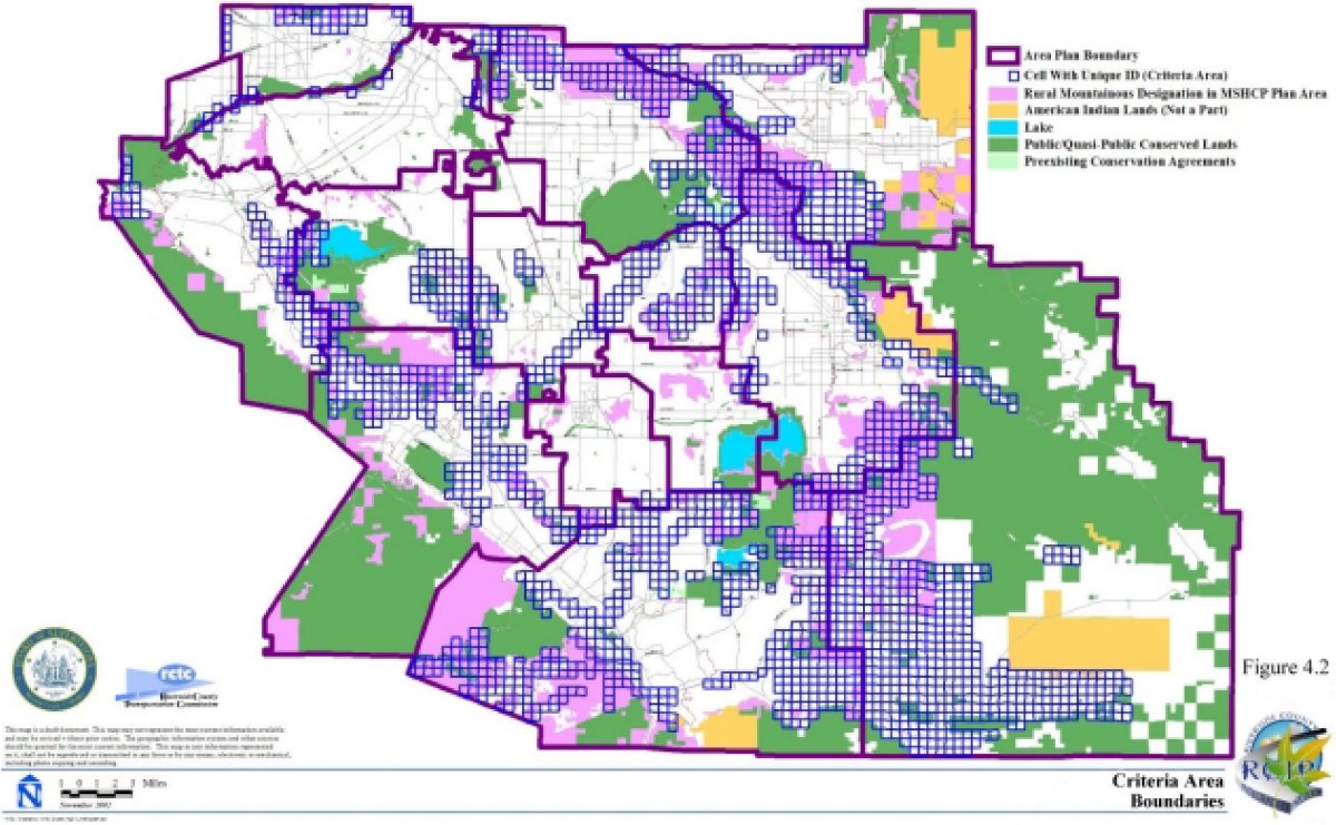
The LDMF will also contribute to the cost of administration of the assembly of the Conservation Area system. In order to ensure that the land acquired with the fees meets the Conservation goals of the MSHCP, a Regional Conservation Authority ("RCA") has been created. The RCA is responsible for identification of and decisions regarding local Conservation Area Land acquisitions and local funding priorities based on adopted MSHCP Conservation Area Design Criteria and conservation strategy. In making these decisions the RCA will receive input from the Funding Coordination Committee. In order to provide for an integrated Conservation Area System that will mitigate the direct, indirect, and cumulative impacts on a regional basis, these decisions will be compatible with the Property Owner Initiated HANS process as set forth in Section 6.1.1 of Volume I of the Draft MSHCP.
By being part of a comprehensive integrated plan for Conservation and eliminating or reducing the need for project by project analysis and mitigation, the LDMF allows better local control over land use decisions, provides a sense of certainty for new Development, and contributes to the overall economic vitality of the Plan Area.
The acquisition of property for the MSHCP will also benefit the public by providing large interconnected areas of land which (1) promote species viability, (2) may reduce the need to list additional Covered Species, and (3) provide a secondary benefit of enhancing the overall aesthetic value of western Riverside County.
The discussion presented in this section of the Nexus Report identifies the use to which the fee is to be put as required by Section 66001(a)(2) of the California Government Code.
4.6. DETERMINE THAT THERE IS A REASONABLE RELATIONSHIP BETWEEN THE FEE'S USE AND THE TYPE OF DEVELOPMENT PROJECT UPON WHICH THE FEE IS IMPOSED (BENEFIT RELATIONSHIP) (GOVERNMENT CODE SECTION 66001(A)(3))
As thoroughly discussed in Sections 4.4 and 4.5, it is the projected cumulative effect of future development that has required the preparation and implementation of the MSHCP to protect multiple habitats and multiple endangered species. Each development will contribute to the need for new regional infrastructure which, in turn, will adversely affect species and habitats. Without future development, existing habitat would not be in danger of permanently disappearing, and those endangered species currently residing within that habitat could be sustained. Even future development projects that may not be located on property that is suitable for habitat purposes contribute to impacts on species because they are an interactive component of a much greater universe of development located throughout the Plan Area. First, the property owners and/or the tenants associated with any potentially non-habitat development regularly utilize and benefit from public roads, flood control facilities and other regional infrastructure, some of which are located on properties that are suitable for habitat purposes. Second, these property owners and tenants are dependent on and, in fact, may not have chosen to utilize their development, except for residential, retail, employment and recreational opportunities located nearby on other existing and future development, some of which has been or will be located on sites that constitute suitable habitat. Third, the availability of residents, employees and customers from this non-habitat development has a growth-inducing impact without which some of the development on habitat properties would not have occurred. As a result, all development projects within the region contribute to the cumulative impacts of development that constitute one of the primary reasons for the disappearance of suitable habitat for endangered species throughout the region. In addition, the purchase of habitat properties for preservation purposes with regionally-generated fees not only mitigates the endangered species habitat issue, but also helps resolve other regional problems related to the retention of open space and historic viewsheds which, in turn, promote flood protection and water re-charge measures.
As the Plan Area is developed, all types of Development (i.e. residential, commercial, industrial, and public infrastructure) will use up more and more available habitat areas. In general terms, all types of Development will have an impact on Covered Species and Habitat because it is the depletion of land in its natural state and the introduction of inhospitable land covers that severely impact the viability and conservation of species and thus increases the probability for extinction.69 Indeed private development activity and related public infrastructure improvements necessarily deplete, both directly and cumulatively, open space and Habitat area that would otherwise remain available to support the goals of the various general plans, some of which are presented in Section 4.4. Of particular importance are the cumulative impacts associated with new Development, all of which are to be taken into account when determining the benefit relationship.
The regional nature of the LDMF is similar to that of the impact fees that are levied by most municipalities for purposes of funding regional roads, flood control facilities, parks and other infrastructure. All new development within a municipality contributes to the construction of major regional arterials that are built at appropriate sites (e.g., connected to freeway off-ramps), even though some of the development paying road impact fees is not located directly adjacent to many of these arterials. Similarly, a water retention facility may be purchased by a municipality at the bottom of a hill because that is the most appropriate location for such a facility, even though properties throughout the drainage basin contribute fees to fund the facility. Regional parks are also developed at certain key locations based on site availability, scenic beauty and other factors, yet new development throughout a municipality is required to pay for these parks. The acquisition of Habitat utilizing MSHCP fees collected throughout a region is based on the same concept.
As set forth in Sections 4.4 and 4.5 of the Nexus Report, the LDMF will be expended to purchase Habitat lands and other authorized uses, as that is the purpose for which the LDMF is collected. The LDMF will be used to acquire the mitigation lands required by FESA, NCCP Act, and related environmental statues. Numerous biological studies document the species and Habitat presently existing in the Plan Area. (See Volumes III and IV of the Draft MSHCP.) As discussed in Section 2.3.5, several conservation biology principals were incorporated into the Conservation Area design. One of the significant features of the MSHCP Conservation Area is connectedness through landscape Linkages and movement corridors. Connectedness is important because Habitat fragmentation and isolation may lead to extinction of local populations and threaten biological diversity. By providing a source of funding to acquire large pieces of interconnected Habitat, the LDMF promotes biological diversity and helps reduce the potential for extinction of local populations.
Moreover, this impact is generally equalized among all types of Development because it is the conversion of land from its natural state, whether for a private development project or a public infrastructure project to serve and support the private development project, that creates the impact upon species and open space opportunities. For the foregoing reasons, there is a reasonable relationship between the purchase of Habitat and all Developments in the Plan Area as required under Section 66001(a)(3) of the Mitigation Fee Act.
4.7. DETERMINE HOW THERE IS A REASONABLE RELATIONSHIP BETWEEN THE NEED FOR THE PUBLIC FACILITY AND THE TYPE OF DEVELOPMENT PROJECT UPON WHICH THE FEE IS IMPOSED (IMPACT RELATIONSHIP) (GOVERNMENT CODE SECTION 66001(a)(4))
As set forth in Sections 4.4, 4.5, and 4.6, all new development contributes to the cumulative impacts on habitat and species. In fact, it is the projected cumulative effect of future development that has required the preparation and implementation of the MSHCP to protect multiple habitats and multiple endangered species. Each development will contribute to the need for new regional infrastructure which, in turn, will adversely affect species and habitats. Without future development, existing habitat would not be in danger of permanently disappearing, and those endangered species currently residing within that habitat could be sustained. Even future development projects that may not be located on property that is suitable for habitat purposes contribute to impacts on species
because they are an interactive component of a much greater universe of development located throughout the Plan Area. First, the property owners and/or the tenants associated with any potentially non-habitat development regularly utilize and benefit from public roads, flood control facilities and other regional infrastructure, some of which are located on properties that are suitable for habitat purposes. Second, these property owners and tenants are dependent on and, in fact, may not have chosen to utilize their development, except for residential, retail, employment and recreational opportunities located nearby on other existing and future development, some of which has been or will be located on sites that constitute suitable habitat. Third, the availability of residents, employees and customers from this non-habitat development has a growth-inducing impact without which some of the development on habitat properties would not have occurred. As a result, all development projects within the region contribute to the cumulative impacts of development that constitute one of the primary reasons for the disappearance of suitable habitat for endangered species throughout the region. In addition, the purchase of habitat properties for preservation purposes with regionally-generated fees not only mitigates the endangered species habitat issue, but also helps resolve other regional problems related to the retention of open space and historic viewsheds which, in turn, promote flood protection and water re-charge measures.
At present and in recent years, as proponents of public and private Developments in both the incorporated and unincorporated areas of Riverside County have been required to obtain project specific Incidental Take permits from Wildlife Agencies for impacts to Endangered, Threatened, and rare Species and their Habitats. Not only does this practice result in costly delays to public and private Development projects, it has also resulted in an assemblage of unconnected Habitat areas, which is counter productive to sustaining wildlife mobility, genetic flow, or ecosystem health. Large, interconnected natural areas are needed for species viability;70 consequently a comprehensive coordinated regional effort is needed to mitigate the effects of Development on Species and their Habitats.
For the reasons presented herein, there is a reasonable relationship between the need for the public facility and all new development in the Plan Area as required under Section 66001(a)(4) of the Mitigation Fee Act.
4.8. THE RELATIONSHIP BETWEEN THE AMOUNT OF THE FEE AND THE COST OF THE PUBLIC FACILITY (HABITAT ACQUISITION) ATTRIBUTABLE TO THE DEVELOPMENT UPON WHICH THE FEE IS IMPOSED ("ROUGH PROPORTIONALITY" RELATIONSHIP) (GOVERNMENT CODE 66001(a)
As set forth above, each Development in the Plan Area impacts the supply of available land for Habitat. Moreover, each individual Development project and its related necessary infrastructure improvements, when examined along with the cumulative impacts of all development in western Riverside County, will have an adverse impact on the availability of open land, Habitat, and species in the Plan Area. Thus, imposition of the LDMF to finance the acquisition of Habitat and appropriate costs associated therewith is the most efficient, practical, and equitable method of permitting development to proceed in an environmentally responsible manner and in a manner that complies with the overall intent of RCIP and the MSHCP.
New Development impacts species and habitat directly, indirectly, and cumulatively. In fact, without any future Development, the MSHCP would not be necessary as existing habitat would not be in danger of permanently disappearing, and those endangered species currently residing within that habitat could be sustained. New residential and non-residential development directly impacts species and habitats by converting natural Habitat to inhospitable land covers. When Habitat conversion takes place between occupied or potential Habitat areas, not only is there an overall loss in Habitat quantity, the quality of the aforementioned remaining occupied or potential Habitat is degraded since these areas may become isolated and impede species movement. Direct, indirect, and cumulative impacts to Habitat result from Future Development's need for public facilities and infrastructure. New public buildings, road improvements, flood control, and water and sewer facilities will need to be constructed or existing facilities expanded to serve new residents and employees, resulting in a loss and/or degradation of natural habitat.
New Development located outside the Criteria Area contributes to the loss and/or degradation of habitat since the property owners and/or the tenants associated with this future Development will utilize and benefit from public roads, flood control facilities and other regional infrastructure, which will be constructed within the Criteria Area. Furthermore new Development outside the Criteria Area has a growth-inducing impact without which some of the Development within the Criteria Area would not take place. Consequently, all Development projects within the region contribute to the cumulative impacts of development that constitute the main reason for the disappearance of suitable habitat for endangered species throughout the Plan Area.
4.8.1 LOCAL ACQUISITION AND OTHER APPROPRIATE COSTS
The amount of the fee is a function of the costs to acquire 56,00071 acres of Habitat subject to the acquisition criteria and the administrative expenses associated with implementing the MSHCP. The MSHCP document provides a rough estimate of the costs to acquire 56,000 acres of Habitat and makes reference to the Nexus Study to develop an appropriate fee amount.72 While the type of general estimate contained in the MSHCP is useful for policy and planning purposes, a more refined analysis is required for purposes of determining the fee amount and satisfying the rough proportionality requirement of the Mitigation Fee Act.
Since the MSHCP is a criteria based plan, there is no "hard-line" boundary that identifies the specific areas to be conserved. The MSHCP Conservation Area will instead be assembled over time based on the Criteria and assurances incorporated in the MSHCP. In order to derive cost estimates that will be used to calculate the amount of the LDMF, a "Probable Overall Value" was developed for each General Plan Land Use Foundation Element.73.
4.8.1.1. Existing Local Acquisition to the MSHCP
As discussed throughout this Nexus Report, the MSHCP Reserve Area includes Local Acquisitions totaling 56,000 acres of new mitigation land. As of February 2003, local sources, that is sources other than the state and federal government, have provided a total of 2,454 acres of new mitigation land, which may be applied to meeting the goal of the Local Acquisition of 56,000 acres, resulting in a remainder of 53,546 acres to be acquired using the LDMF. Therefore, the projected acquisition cost for the Local Acquisitions will be based on 53,54674 acres.
4.8.2 PROBABLE OVERALL VALUE METHODOLOGY
In order to estimate the costs to acquire 53,546 acres of new mitigation land, an analysis was undertaken to determine the probable overall value of property within the Criteria Area. This analysis is summarized in this section, with the entire report included as Appendix B to the Nexus Report.
The probable overall valuation analysis for the MSHCP estimates a probable per acre value for the different Foundation Components75 within each of the 16 Area Plans within the Plan Area. Sufficient land sales within the Plan Area were gathered and over 300 land sales within Riverside County and adjacent counties were reviewed in order to estimate a probable per acre value for each of these 16 Area Plans.
Each Area Plan was broken into three Foundation Components, and each Foundation Component was valued separately. 76 Exact values for specific parcels within western Riverside County have not been determined. Instead, probable per acre values for the Foundation Components within general areas of Western Riverside County have been estimated for use in the Nexus Report.
Of the Foundation Components, Community Development land uses are estimated to have the highest probable per acre value ranging from $20,000 per acre to $80,000 per acre, with the highest probable value per Community Development acre being within the Cities of Riverside/Norco Area Plan. Rural & Agricultural land uses are projected to have a probable per acre value much lower than Community Development land uses, ranging from $5,000 per acre to $25,000 per acre, with the highest probable value per Rural & Agricultural acre being within the Cities of Riverside/Norco Area Plan. Open Space land uses have the lowest projected probable per acre value ranging from $2,500 per acre to $10,000 per acre, with the highest probable value per Open Space acre being equal in the Eastvale, Highgrove, Southwest, and Temescal Canyon Area Plans.
4.8.3 ELIGIBLE USES OF THE LDMF
Eligible uses of the LDMF include the acquisition of approximately 53,546 acres of Habitat and other appropriate uses, each of which are discussed in the following paragraphs.
4.8.3.1. Land Acquisition Costs
The MSHCP is an incentive and criteria driven plan in which Habitat acquisition is one of many tools that will be used to assemble the conservation area. As a criteria based plan, there is no "hard-line" boundary that identifies the specific property to be conserved. Habitat acquisition will take place in accordance with the provisions of the MSHCP as both funding and appropriate land becomes available.
In order to estimate the costs associated with the acquisition of 53,546 acres of Habitat, it is assumed that Habitat will be acquired from each Area Plan in proportion to that Area Plan's share of the sum of the median number of acres within the Criteria Range for all Area Plans. For example, if the median number of acres in the Criteria Range for the Eastvale Area Plan is 220 and the sum of the median number of acres in the Criteria Range for all of the Area Plans in the MSHCP is 159,405, it is assumed, for purposes of this Nexus Report, that 0.14% of the 53,546 acres of Habitat to be acquired, or 74 acres, will be acquired within the Eastvale Area Plan.
Within a given Area Plan, it is reasonable to assume for purposes of this Nexus Report, that the amount of Habitat to be acquired from each Foundation Component is in proportion to that foundation component's share of that Area Plan's Criteria Area. Using the Eastvale Area Plan as an example, if the Criteria Area within the Eastvale Area Plan is: 8% Community Development, 0% Rural, 0% Agricultural, and 92% Open Space, then 8% of the Habitat to be acquired, or 6 acres, is assumed to be designated as Community Development property. Based on these assumptions the following methodology was used to estimate Local Acquisition costs.
1. Using the Criteria Area acreage ranges presented in Volume I of the MSHCP and summarized below, estimate the median number of acres of habitat to be conserved on private lands within each Area Plan and calculate each Area Plan's pro rata share (expressed as a percentage) of the Habitat to be conserved on private land. The results of this are presented in Table 4-1.
2. Allocate the 53,546 acres of Habitat to be acquired to each Area Plan based on the percentages determined in step 1 and identified in the column under the heading "Portion of Conserved Area" in Table 4-1, above. Table 4-2 presents the results of this step.
3. Using GIS data developed as part of the MSHCP, determine the number of acres within the Criteria Area of each General Plan Foundation Component for each Area Plan.77 The data collected in this step is summarized in Table 4-3
4. Using the acreage within each Foundation Component presented in Table 4-3, above, determine the percentage of Habitat for each Foundation Component type based on the acreage within the Criteria Area in each Area Plan. The results of this calculation are presented in Table 4-4.
5. Assign the 53,546 acres to be acquired to each Foundation Component in each Area Plan based on the total acres to be acquired in each Area Plan as determined in Table 4-2 and the percentages for each Foundation Component from Table 4-4 to determine the number of acres to be acquired in each Foundation Element in each Area Plan. The results of this step are presented in Table 4-5.
6. Project the probable acquisition cost by (a) multiplying the probable overall value per acre (from Appendix B) times the number of acres in each Foundation Component (from Table 4-5) to determine the projected acquisition costs for each Foundation Component for each Area Plan; (b) Add the results from clause (a) to determine the projected acquisition cost for each Area Plan; (c) Add the results from clause (b) to determine the projected acquisition costs for the entire 53,546 acres. The results of these calculations are presented in Table 4-6 below.
As indicated in Table 4-6, the Probable Acquisition Cost is $876,729,808, which results in an average acquisition cost of approximately $16,400 per acre.
4.8.3.2. Other Appropriate Costs
The MSHCP will be implemented, overseen, and administered by the Western Riverside County Regional Conservation Authority (‘RCA"). The RCA will be a joint regional authority formed by the County and the Cities pursuant to the requirements of the California Government Code and other statutes as applicable. The RCA will be authorized to carry out the requirements of the MSHCP and will have overall program responsibility for the assembly of the Local Acquisitions. Consequently, costs associated with the RCA's efforts to acquire Habitat, either by acquisition or some other means, are appropriate costs and will be financed with LDMF funds.
RCA's estimated annual budget is approximately $1,198,650 per year in 2003 dollars.78 Since the Nexus Report addresses certain financial needs of the MSHCP for a 25 year period, RCA's annual budget was multiplied by 25 with the resulting product representing the overall administrative costs for the acquisition period (in 2003 dollars). Using this methodology, RCA's budget for the 25 year acquisition period is approximately $30 million, which is approximately 3% of the Probable Acquisition Costs.
4.8.3.3. Total Cost to be Financed Through Mitigation Fee Program
As discussed in Section 4.8.3, the LDMF may be used for habitat acquisition and Other Appropriate Costs. The total cost to be financed through the LDMF program is the sum of the Probable Acquisition Costs ($876,729,808) plus the Other Appropriate Costs79 ($30,000,000) for a total LDMF program cost of $906,729,808.
4.8.4 AREA OVER WHICH THE LDMF IS TO BE IMPOSED (WHY A REGIONAL FEE?)
It is the projected cumulative effect of future development that has required the preparation and implementation of the MSHCP to protect multiple habitats and multiple endangered species. Each development will contribute to the need for new regional infrastructure which, in turn, will adversely affect species and habitats. Without future development, existing habitat would not be in danger of permanently disappearing, and those endangered species currently residing within that habitat could be sustained. Even future development projects that may not be located on property that is suitable for habitat purposes contribute to impacts on species because they are an interactive component of a much greater universe of development located throughout the Plan Area. First, the property owners and/or the tenants associated with any potentially non-habitat development regularly utilize and benefit from public roads, flood control facilities and other regional infrastructure, some of which are located on properties that are suitable for habitat purposes. Second, these property owners and tenants are dependent on and, in fact, may not have chosen to utilize their development, except for residential, retail, employment and recreational opportunities located nearby on other existing and future development, some of which has been or will be located on sites that constitute suitable habitat. Third, the availability of residents, employees and customers from this non-habitat development has a growth-inducing impact without which some of the development on habitat properties would not have occurred. As a result, all development projects within the region contribute to the cumulative impacts of development that constitute one of the primary reasons for the disappearance of suitable habitat for endangered species throughout the region. In addition, the purchase of habitat properties for preservation purposes with regionally-generated fees not only mitigates the endangered species habitat issue, but also helps resolve other regional problems related to the retention of open space and historic viewsheds which, in turn, promote flood protection and water re-charge measures.
As previously discussed in the Nexus Report, the past practice of piecemeal and ad hoc mitigation on a local or project by project basis has resulted in fragmented, uncoordinated, and unconnected habitat areas. While this practice may have addressed project specific impacts associated with individual development projects, it has resulted in costly delays, conflicts over species conservation, and has negatively impacted the ability of local jurisdictions to plan and build regional infrastructure needed to support planned development and sustainable economic growth, both of which are necessary to maintain a high quality of life in the County. Uncoordinated efforts at habitat mitigation are both costly and time consuming and the resulting habitat may not create large interconnected natural areas needed to sustain wildlife mobility, genetic flow, or ecosystem health.80 The proponents of both private and public development projects are expending significant amounts of time and money on mitigation, but as these efforts are not coordinated the result is habitat fragmentation. Habitat fragmentation is an extremely serious threat to biological diversity since isolated local populations of species are more likely to become extinct. Accruing financial resources such as the LDMF on a region-wide basis and utilizing these monies to purchase those critical sites throughout the region that are best suited (or most appropriately priced) for habitat purposes will provide the best protection for the region's endangered species given the limited funding sources available
A regional LDMF is both appropriate and justifiable, since the MSHCP was designed to mitigate direct, indirect, and cumulative impacts resulting from new Development and the infrastructure necessary to support and serve such development. All new Development in the Plan Area, plus the additional roadways and public facilities needed to serve such Development impact the supply of open space and habitat on an individual and cumulative basis. Even future development projects that may not be located on property that is suitable for habitat purposes contribute to impacts on species because they are an interactive component of a much greater universe of development located throughout the Plan Area and:
Although it is far more common to deal with regionalization in relation to transportation, flood control, or other utilities, the MSHCP is no different. Every project adds trips to local roads but also to the regional transportation system. Likewise every new development project increases the demand for water or sewer capacity, libraries and other public facilities. In these instances contribution to regional needs or a regional system is well established. The impacts to habitat and species are much the same through impacts resulting from increased urbanization and from the construction of new infrastructure to meet the demands of new development. A regional approach provides equity in addressing the impacts to species and habitat of new development.
For the reasons articulated above as well as those previously articulated in Sections 2, 3, and 4, it is appropriate that all new Development participate in the mitigating these impacts.
4.8.5 DEVELOPMENT HORIZON USED IN THE NEXUS REPORT
The LDMF calculations presented in the Nexus Report are based on new development projected to occur in the Plan Area in the next 25 years. The main rationale for the selection of this development horizon is the MSHCP calls for assembly of the Reserve Area within a 25 year period. In order to obtain an Incidental Take Permit ("ITP"), which will allow planned development and public infrastructure to take place within the Conservation Area, a habitat conservation plan (HCP) must be approved. Approval of an HCP requires that the applicant ensure "adequate funding" is provided. In the specific instance of the MSHCP, adequate funding includes the costs to complete the Local Acquisitions within the first 25 years after the ITP is issued, as well as, the costs for Program Administration, both of which will be provided by the LDMF. The other costs, adaptive management, reserve management, and biological monitoring will be funded from other sources as discussed in Section 5.
Given the current development pressure within the Criteria Area, if the Local Acquisitions are not completed in the next 25 years, important resources may become developed, or surrounded by new development to the extent that the land may become isolated from other habitats. This is significant since the loss of important habitats over the next 25 years will preclude assembly of the Conservation Area. The MSHCP calls for the Local Acquisitions to be completed within 25 years to ensure that the resources, particularly those related to linkages, are still available.
If the LDMF does not generate sufficient revenue within a 25 year period to fund acquisition of the 53,546 acres, the MSHCP will not be able to meet the FESA condition that adequate funding is provided and the ITP cannot be issued.
After assembly of the Reserve Area, the MSHCP will have ongoing financial obligations and the fee program will not end in 25 years. New Development in year 26 and beyond will still have the obligation to mitigate per CEQA, as well as, finance ongoing Program Administration. If revisions are made to the California Government Code at some future date, the LDMF could possibly be collected to finance adaptive management, reserve management and/or biological monitoring.
4.8.6 EXISTING DEFICIENCIES
With respect to deriving the LDMF, David Taussig & Associates, Inc. ("DTA") has determined there are no existing deficiencies in habitat lands that are mitigated by the MSHCP. The MSHCP Conservation Area was neither sized nor designed to "make-up" for existing deficiencies in habitat land. Rather, the MSHCP is a prospective plan and provides mitigation for the direct, indirect, and cumulative impacts to Covered Species and their Habitats resulting from new Development and the additional roadways and other public facilities needed to serve such Development in the Plan Area. Therefore, the entire cost of the Local Acquisitions and program administration component of the MSHCP is eligible to be allocated to new development.
The MSHCP provides take authorization for future development. If no additional new development occurred within the Plan Area there would be no "take" of habitat and no need for the MSHCP or the LDMF. The mitigation required and provided under the MSHCP is that which is necessary to mitigate the impacts of future development. While the loss of habitat in the past may have resulted in a situation where further loss of habitat threatens the survival of many species, the fact is that if no new development or infrastructure needed to serve said new development were constructed, there would be no need to mitigate direct, indirect, or cumulative impacts to the Covered Species or their Habitat.
However as discussed in Sections 1 and 2, a significant amount of new development and new infrastructure is anticipated in the Plan Area and state and federal laws, as well as local land use policies, require new development to mitigate or avoid impacts to species and their habitats. Since, as previously discussed in Section 4.4, 4.5, 4.6, and 4.7 of the Nexus Report, all new development in western Riverside County will impact the Covered Species or their habitat either directly, indirectly or cumulatively.
The MSHCP calls for new development in the Plan Area to provide 103,000 acres of new habitat. The LDMF will finance only the acquisition of 56,000 acres (less those that have already been locally conserved). Out of a total reserve system of 500,000 acres the LDMF is contributing only slightly over 10% of the total Conservation Area.
4.8.7 CALCULATION OF MITIGATION FEE AMOUNTS
4.8.7.1. What Type of Fee Methodology is Appropriate for the LDMF?
Government Code 66000 does not specify the manner in which an impact fee must be derived. It does, however, set forth a series of requirements that a public agency must satisfy before establishing, increasing, or imposing a fee as a condition of new development. These requirements, specifically the requirements regarding the presence of a reasonable relationship between the need for the facility and the type of development project upon which the fee is to be imposed, the requirement that a reasonable relationship exist between the amount of the fee and the cost of the public facility and the requirement for a reasonable relationship between the amount of the fee and the costs of the facilities, will shape the methodology used to establish mitigation fees for a specific project.
In making a determination as to the type of fee methodology to be used for a specific project, one generally starts with identifying the impacts that are being mitigated by the facility being financed with the fee revenues. Typically this is a straightforward analysis. For example a mitigation fee to finance domestic water facilities would most likely be a function of the water meter size or the expected water consumption. A fee to mitigate flood control improvements would most likely be based on lot size and runoff coefficients.
As established in the Nexus Report, implementation of the MSHCP will allow the Development of not only private projects but also the public infrastructure necessary to serve the private development. That is, implementation of the MSHCP will provide mitigation for more than the loss of biological resources. In recognition of the wide variety of impacts mitigated by implementation of the MSHCP, the Nexus Report will derive mitigation fees using methodologies based on different criteria - gross acreage, density, equivalent dwelling units (EDUs), and equivalent benefit units (EBUs).
The LDMF calculations presented in the Nexus Report are based on new development projected to occur in the Plan Area in the next 25 years. However, the MSHCP will have ongoing financial obligations, and the fee program will not end in 25 years. Furthermore new Development occurring after the development horizon used in this Nexus Report, will still have the obligation to mitigate per CEQA as well as, finance ongoing Program Administration. If revisions are made to the California Government Code at some future date, the LDMF could possibly be collected to finance adaptive management, reserve management and/or biological monitoring.
4.8.7.2. Gross Acreage Based Fee Methodology
A fee based on the acreage of the area benefiting from the improvements is one way to structure a fee program. However, an acreage based fee structure is limited in the scope of its applicability since the basic assumption underlying this methodology is that every acre equally impacts the facility being financed. This methodology does not take into consideration differences in impacts resulting from differing land uses (i.e. residential vs. non-residential development) nor does it recognize that similar land uses have similar impacts irrespective of differing lot sizes. For example, with a straight gross acreage based fee structure, the fee amount for a single-family home on a 10 acre residential lot would be identical to the fee amount for a 10 acre business park, twice as high as the fee amount for a 5 acre strip commercial center, and 20 times as high as the fee amount for a mini market on a one-half acre lot. With respect to residential development, unless a cap is placed on the amount of acreage subject to the LDMF, the fee amount for a single-family home on a 10 acre lot would be 10 times as high as the fee amount for an identical home on a 1 acre lot, and 60 times as high as the fee for the same home on a 7,200 square foot lot.
The construction of individual single-family homes on existing legal parcels is a Covered Activity inside the criteria area.81 The Draft EIR/EIS for the MSHCP states the average lot size for units constructed in the criteria area between 1995 and mid-2002 is approximately 9 acres.82 In permitting the development of single-family homes in the criteria area on larger lots, the MSHCP recognizes that there is some conservation value associated with single-family residential development on large lots. In fact, the MSHCP states that rural residential development has less edge effect than more dense development. That is, the MSHCP acknowledges different types of land uses have different impacts on conservation and biological resources. In consideration of the recognition of the conservation value associated with rural and larger lot residential development, the gross acreage based LDMF proposed would be imposed on a maximum of 0.5 acres for single-family detached residential lots greater than 0.5 acres in size. Therefore if the gross acreage based LDMF as proposed is adopted, the LDMF for a 10 acre single-family residential lot would be the same as a 0.5 acre single-family detached residential lot and 3 times greater than a type of development, in this instance a 7,200 square foot residential lot, which provides less conservation value
Methodology Employed to Calculate an Acreage Based LDMF
- Project the number of acres of rural, residential, commercial, industrial and business park, community center, and city mixed-use and city-special planning that will be developed in the next 25 years.
- Divide the total cost to be financed through the mitigation fee program, $906,729,808 by the projected number of developed acres to determine the LDMF per acre.
Development Projections for the Acreage Based LDMF
In order to project the number of acres of new development expected to occur in the next 25 years, David Taussig & Associates, Inc. ("DTA") obtained data compiled for the Plan Area by RBF, the GIS consultant for the RCIP. The RCIP data provides undeveloped acreage by Area Plan for the following categories: rural residential, rural mountainous, rural desert, very low residential, low residential, medium residential, medium high residential, high residential, very high residential, commercial retail, commercial tourist, commercial office, light industrial, high industrial, business park, public facilities, community center, Indian lands, freeway, open space conservation, open space conservation habitat, open space rural, open space recreation, open space water, open space mineral resources, agriculture, city-mixed use, and city-special planning area. A table summarizing this data is included in Appendix D. DTA projected the number of developed acres expected within the next 25 as follows:
- Sum the data from the RCIP database (Appendix D) to determine the number of gross acres of new development within each land use class at buildout (Table 4-7, column [1]).
- To project the number of acres of rural residential development that will be subject to the LDMF, DTA applied a developable acreage factor of 75% and an absorption factor of 30% to the gross acres of rural land uses83 to project the number of acres of new rural development expected in the next 25 years. The resulting product was divided by the average minimum residential lot size in the rural land use designations (10 acres)84 to project the number of new single-family detached homes in the next 25 years, the resulting product was multiplied by 0.5, which represents the maximum acreage upon which the LDMF would be imposed for (Table 4-7, column [2]).
- To project the number of acres of very low density residential development that will be subject to the LDMF, DTA applied a developable acreage factor of 75% and an absorption factor of 67% to the gross acres of very low density residential property85 to project the number of acres of new very low density residential development expected in the next 25 years. The resulting product was divided by the average minimum very low density residential lot size (1.25 acres)86 to project the number of new single-family detached homes in the next 25 years, the resulting product was multiplied by 0.5, which represents the maximum acreage upon which the LDMF would be imposed for (Table 4-7, column [2]).
- To project the number of acres of all other land uses, DTA applied a developable acreage factor of 75% and an absorption factor of 67% to the gross acres of all other residential property, commercial, industrial and business park, community center, city mixed-use and city-special planning land uses87 to project the number of acres of new development expected in the next 25 years (Table 4-7, column [2]).
Table 4-7 presents the development projections (columns [1] and [2]) and the recommended LDMF per gross acre (column [3]).
4.8.7.3. Density Methodology
Deriving mitigation fees based on the density of residential development provides a way to quantify different land use types in terms of their equivalence to a predefined unit where equivalence is measured in terms of density, which provides a correlation to potential use or benefit. A major advantage to a density weighted ("DW") methodology when compared to an acreage based methodology, is the ability to assign identical benefits to similarly used properties, e.g. all residential property within a density rage that is typical for a certain type (i.e. single-family vs. multiple-family residential development) may be assigned 1 DW, or assign different DWs to reflect differences in land uses, e.g. residential development vs. non-residential development.
The Nexus Report proposes a DW based fee structure where DWs are a function of the expected density of residential development. Using density as the basis for the fee program recognizes, in a qualitative sense, that more land may be available for biological resources and less infrastructure may be required when more people are housed on less land. For example, a 25 home residential project with a density of 7 units per acre would require approximately 3.5 acres of land whereas those same 25 units constructed at a density of 4 units per acre would require approximately 6.2 acres. A DW based fee program also provides a means to differentiate between the impacts associated with residential and non-residential development.
Assignment of Density Weights
Under the DTA's proposed DW methodology, 1 DW is assigned to each rural residential dwelling unit and to each dwelling unit constructed on residential property with a density from 0.4 to 8 dwelling units ("DU") per acre (Table 4-8). Residential property developed at a density between 0.4 and 8 dwelling units per acre represents single-family detached residential development88 and becomes the basis upon which the impacts of other types of development are measured. Dwelling units constructed on rural residential property are assigned a DW of 1 even though they are constructed at a lower density because (i) this type of property will be developed with single-family detached residential units similar to those constructed in a 0.4-8 DU/acre project, and (ii) in recognition of the potential conservation value of rural development as previously discussed in the acreage based fee methodology section.
Expected development on residential property with a density between 8.1 and 14 DU/ acre includes attached residential units, townhouses, stacked flats and courtyard homes.89 These types of units are more densely developed than traditional single-family detached housing and thus may cause less impact to biological resources by housing more people on less land. Furthermore, trip generation rates and population per unit are generally lower than that of single-family detached units as evidenced by data compiled by the Institute of Traffic Engineers and U.S Census 2000. As indicated in Table 4-8, 0.4 DW per unit is assigned to this type of development based on the relationship of the midpoint density for residential property with a density of 8-14 DU/acre (midpoint = 11 DU/acre) compared to the midpoint density for residential property with a density of 0.4-8 DU/acre (4.2).90
A density weight (DW) is assigned to each acre of residential development with a density greater than 14 dwelling units per acre and commercial and industrial development based on actual expected density associated with residential property developed at 0.4-8 DU/acre. In order to determine this number, DTA divided the expected number of residential units with a density between 0.4-8 DU/acre by the expected number of acres for that land use. As indicated in Table 4-9, a total of 332,940 residential units with densities between 0.4-8 DU/acre are projected on 98,909 gross acres, which results in an DW assignment of 3.4 DWs per acre for residential projects with densities in excess of 14.1 DU/acre and 3.4 DWs per acre for commercial and industrial projects. The high and very high density residential projects are assigned the same number of DWs as commercial and industrial projects since high and very high density residential projects are more similar in nature to commercial projects than to single-family projects.
It is DTA's opinion that the density weighted LDMF is superior to the Gross Acreage methodology in that one can use a project's density to differentiate between "types" of development, both residential and non-residential. A shortcoming to the density weighted fee structure is that while there is a good rationale and data to support a difference in the fee amounts between different types of residential units, unless a large number of density categories are defined, the resulting fee structure may result in large breaks between density classes.
Methodology Employed to Calculate the Density Based LDMF
- Project the number of new rural residential units, units constructed at a density between 0.4-8 DU/acre and units constructed at a density between 8-14 DU/acre in the next 25 years (Table 4-8, column [2]).
- Project the number of acres of new residential projects with a density greater than 14 DU/acre, commercial, and industrial development in the next 25 years(Table 4-8, column [2]).
- Apply the applicable DW factor to each land use type (Table 4-8, column [1])
- For each land use category, multiply the number of expected dwelling units or developed acres times the applicable DW to determine the total number of DW units per land use category (Table 4-8, column [3]).
- Sum the DW units for each land use category to determine the total DW units in 25 years.
- Divide the total cost to be financed through the mitigation fee program, $906,729,808 by the projected number of DW units to determine the LDMF per DW ($2,412 as indicated in Table 4-8).
- Multiply the LDMF per DW times the DWs assigned to each land use category to determine the LDMF per unit or LDMF per acre (Table 4-8, column [4]).
Table 4-8
Local Development Mitigation Fee Amounts
Density Based Methodology 1 |
|---|
| |
[1] |
[2] |
[3] |
[4] |
|---|
| Land Use Category |
Density |
Density Weight Factors |
Expected
Dwelling Units
in 25 Years |
Expected
Density
Weight Factors
in 25 Years [1]*[2] |
Proposed
Fee per
Dwelling Unit
or Acre-
Acquisition and
Administration |
|---|
Low End
Density
(DUs/Acre) |
High End
Density
(DUs/Acre) |
Density
Mid-Point
(DUs/Acre) |
|---|
| Rural Residential |
NA |
NA |
NA |
1.0 |
6,972 |
6,972 |
$2,414 |
| Residential, density between 0.4 to 8.0 dwelling units per acre |
0.4 |
8 |
4.20 |
1.0 |
290,201 |
290,201 |
$2,414 |
| Residential, density between 8.1 and 14.0 dwelling units per acre |
8 |
14 |
11.00 |
0.4 |
11,620 |
4,648 |
$965 |
| Total |
|
|
|
|
308,793 |
301,821 |
|
| |
|
|
|
|
Expected New
Developed Acres
in 25 Years |
|
|
| High and Very High Density Residential, density greater than 14.1 dwelling units per acre |
Greater than 14.1 dwelling units per acre |
3.4 |
1,535 |
5,219 |
$8,208 |
| Commercial |
NA |
NA |
NA |
3.4 |
6,888 |
23,419 |
$8,208 |
| Industrial |
NA |
NA |
NA |
3.4 |
13,296 |
45,206 |
$8,208 |
| |
|
|
|
|
21,719 |
73,844 |
|
| TOTAL EBUs in 25 Years |
375,665 |
|
| Cost to be Financed Through LDMF |
|
$906,729,808 |
| Cost per DW unit |
|
$2,414 |
Development Projections for the Density Based LDMF
Traffic modeling and other analysis for the CETAP projects are projecting a total of 332,000 new dwelling units in the CETAP project area, which has the same boundaries as the MSHCP, in the next 25 years. This however is where the CETAP projections stop. Since DWs are assigned on the basis of density categories, it is necessary for DTA to project the number of dwelling units within each of the density categories used for the EBU based fees. DTA projected the number of developed acres expected within the next 25 years by:
- Sum the data from the RCIP database (Appendix D) to determine the number of gross acres of new development within each land use class at buildout (Table 4-9, column [1]).
- Apply an absorption factor of 30% to the gross acres of rural land uses91 to project the number of acres of new rural development expected in the next 25 years (Table 4-9, column [2]).
- Apply an absorption factor of 67% to the gross acres of residential, commercial, and industrial and business park land uses92 to project the number of acres of new development expected in the next 25 years (Table 4-9, column [2]).
- Multiply the projected acres of new residential development by the density midpoint for each residential land use category to project the number of dwelling units (the "DTA projected dwelling units, Table 4-9, column [4]). The DTA projected dwelling unit count is approximately 381,000, which is almost 15% higher than the CETAP projection of 332,000 units.
- Determine the portion of DTA projected dwelling units within each residential land use category (Table 4-9, column [5]).
- Allocate the CETAP projected units (332,000) based on the percentages derived in step 5 above (Table 4-9, column [6]).
4.8.7.4. Equivalent Dwelling Unit - Population and Employee Based
An equivalent dwelling unit (EDU) provides a way to quantify different land use types in terms of their equivalence to a single-family residential dwelling unit, which is assigned 1 EDU. DTA proposes an EDU based fee in which the EDUs for multi-family residential property and non-residential property are assigned based on the expected number of people per dwelling unit or expected number of employees per acre, respectively. As with the EBU based fee proposal, an EDU based fee can reflect differences in impacts resulting from different land uses and densities. Using population and employment as the basis for the fee program implies that the main benefit to new development from the MSHCP is the public infrastructure and facilities that will likely be constructed once the MSHCP is implemented. As established in Section 2 of the Nexus Report, these public infrastructure facilities (particularly the transportation facilities) provide significant benefit to new development.
Assignment of EDUs
Under DTA's proposed EDU methodology, a single-family residential unit ("SFR") is defined as dwelling units with a density of less than or equal to 8.0 DU/acre. SFRs, which have a population of 3.1 persons per DU (Table 4-10, column [1]) are defined as 1 EDU. Multiple-family residential ("MFR") property is defined as dwelling units with a density between 8 and 14 dwelling units. MFRs have an expected population per dwelling unit of 2.5 persons93 and are assigned 0.8 EDU per unit (Table 4-10. column [2]).94 Commercial property,95 which has an average of 20 employees per acre, is assigned 6.5 EDUs per acre96 and Industrial property, which has an average of 10.5 employees per acre, is assigned 3.4 EDUs per acre.97 Residential property with densities exceeding 14 DU/acre is assigned to the same land use category as commercial property since those types of high and very high density residential projects are more commercial than residential in nature.
Methodology Employed to Calculate the EDU Based LDMF
- Project the number of new SFR units and new MFR units in the next 25 years (Table 4-10, column [3]).
- Project the number of acres of new residential projects with a density greater than 14 DU/acre, commercial, and industrial developments in the next 25 years (Table 4-10, column [3]).
- Apply the applicable EDU factor to each land use type (Table 4-10, column [2]).
- For each land use category, multiply the number of expected dwelling units or developed acres times the applicable EDU to determine the total number of EBUs per land use category (Table 4-10, column [4]).
- Sum the EDUs for each land use category to determine the total EDUs in 25 years.
- Divide the total cost to be financed through the mitigation fee program, $906,729,808 by the projected number of EDUs to determine the LDMF per EDU ($2,231 as indicated in Table 4-10).
- Multiply the LDMF per EDU times the number of EDUs assigned to each land use category to determine the LDMF per unit or LDMF per acre (Table 4-10, column [5]).
Development Projections for the EDU Based LDMF
The EDU based LDMF uses the same development projections as does the density based LDMF.
4.8.7.5. Equivalent Benefit Unit Methodology
An equivalent benefit unit (EBU) provides a way to quantify different land use types in terms of their equivalence to a predefined unit where equivalence is measured in terms of potential use or benefit. A major advantage to an EBU structured methodology when compared to an acreage, density or population based methodology, is the ability to assign identical benefits to similarly used properties (e.g. all residential property is assigned 1 EBU irrespective of lot size) or assign different EBUs to reflect differences in land uses, (e.g. residential development vs. non-residential development).
The Nexus Report proposes an EBU based fee structure where EBUs for residential development are a function of (i) the expected lot size, (ii) trip generation rates, and (iii) expected population per household. Using a weighted factor for each of these items takes into consideration that the MSHCP is providing mitigation for direct, indirect, and cumulative impacts. An EBU based fee program also provides a means to differentiate between the impacts associated with residential and non-residential development.
Assignment of Equivalent Benefit Units
DTA's proposed EBU methodology has four categories of property, three residential categories defined by density ranges and one non-residential category. The residential categories are: (1) Residential, density between 0 and 8.0 dwelling units per acre, (2) Residential, density between 8.1 and 14.0 dwelling units per acre and (3) Residential, density greater than 14.1 dwelling units per acre. These density ranges were selected as they generally correspond to single-family, multiple-family, and high density multiple-family residential development, respectively.
For purposes of assigning EBUs, to residential property three equally weighted components were used: average lot size, average trip ends, and average population per household. For each of these components, an EBU of 1 is assigned to each dwelling unit constructed on residential property with a density from 0 to 8.0 dwelling units ("DU") per acre since this density range represents single-family detached residential development98 and is the basis upon which the impacts of other types of development are measured. (columns [2], [4], and [6] in Table 4-11). The lot size, trip end and population factors (columns [2], [4], and [6] in Table 4-11) are added together with the resulting sum (column [7], Table 4-11) being the basis for the Overall EBUs (column [8], Table 4-11).
EBUs are assigned to non-residential development based actual expected density associated with residential property developed at 0.4-8 DU/acre. In order to determine this number, DTA divided the expected number of residential units with a density between 0.4-8 DU/acre by the expected number of acres for that land use category. As indicated in Table 4-9, a total of 332,940 residential units with densities between 0.4-8 DU/acre are projected on 98,909 gross acres, which results in an EBU assignment of 3.4 EBUs per acre of non-residential development.
Average Lot Size
Average lot sizes were determined for each residential density range in half acre increments. For purposes of determining the lot size component dwelling units constructed on rural residential property were assigned a lot size of 0.5 acres in recognition of the potential conservation value of rural development as previously discussed in the gross acreage based fee methodology section. The average residential lot sizes are presented in column [1] of Table 4-11. Appendix E contains the worksheet with the backup data.
Average Trip Ends
Average trip ends were determined for each residential density range using trip end factors from "Trip Generation, 5th Edition" published by the Institute of Transportation Engineers. For purposes of this analysis, DTA used trip generation rates for single-family detached housing (9.57 trips per dwelling unit) and apartments (6.63 trips per dwelling unit). The average trip ends are presented in column [3] of Table 4-11 with the backup data in Appendix E.
Average Population per Dwelling Unit
Average population per dwelling unit was determined for each residential density range using "Occupancy Rate per Household Unit" data from the United States Census Bureau, Census 2000 data. For purposes of this analysis, DTA used the occupancy rate for detached dwelling units for residential units with the densities between 0 and 8.0 DU/acre (3.266 people/DU). For residential units with densities between 8.1 and 14.0 DU/ac, DTA used the average of the occupancy rates for 1 attached unit in a structure through 19 units (2.639 people/DU). For residential units with densities greater than 14.1 DU/ac, DTA used the average of the occupancy rates for 19 attached units in a structure through 50 or more units in a structure (2.639 people/DU). These averages are presented in column [5] of Table 4-11 with the backup data in Appendix E.
Methodology Employed to Calculate the EBU Based LDMF
- Project the number of new residential units constructed in the three density ranges in the next 25 years (Table 4-11, column [9]).
- Project the number of acres of commercial and industrial development in the next 25 years (Table 4-11, column [9]).
- Apply the applicable EBU factor to each land use type (Table 4-11, column [8]).
- For each land use category, multiply the number of expected dwelling units or developed acres times the applicable EBU to determine the total number of EBUs per land use category (Table 4-11, column [10]).
- Sum the EBUs for each land use category to determine the total EBUs in 25 years.
- Divide the total cost to be financed through the mitigation fee program, $906,729,808 by the projected number of EBUs to determine the LDMF per EBU ($2,354 as indicated in Table 4-11).
- Multiply the LDMF per EBU times the EBUs assigned to each land use category to determine the LDMF per unit or LDMF per acre (Table 4-11, column [11]).
Table 4-11
Local Development Mitigation Fee Amounts
EBU Methodology, Residential EBU Assignment Based Acreage, Trip Generation, and Population/Employment, Non-Residential EBU based on Residential Density |
|---|
| |
[1] |
[2] |
[3] |
[4] |
[5] |
[6] |
[7] |
[8] |
[9] |
[10] |
[11] |
|---|
| Land Use Category |
Average Lot Size
(DUs/Acre) |
Lot Size Factor |
Average Trip Ends
(Trips/DU) |
Avg. Trip End Factor |
Average Population (People/DU) |
Avg. Pop. Factor |
Total All Factors
([2]+[4]+[6]) |
Overall EBU Assignment |
Expected Dwelling Units in 25 Years |
Expected EBUs in 25 Years
[8]*[9] |
Proposed
Fee per
Dwelling Unit
or Acre-
Acquisition and
Administration |
|---|
| Residential, density between 0 to 8.0 dwelling units per acre |
0.224 |
1.00 |
9.570 |
1.00 |
3.266 |
1.00 |
3.000 |
1.0 |
297,173 |
297,173 |
$2,354 |
| Residential, density between 8.1 and 14 dwelling units per acre |
0.093 |
0.42 |
6.630 |
0.69 |
2.639 |
0.81 |
1.920 |
0.64 |
11,620 |
7,437 |
$1,506 |
| Residential, density greater than 14.1dwelling units per acre |
0.041 |
0.18 |
6.630 |
0.69 |
2.250 |
0.69 |
1.560 |
0.52 |
23,207 |
12,068 |
$1,224 |
| Total |
|
|
|
|
|
|
|
|
332,000 |
316,678 |
|
| |
|---|
| |
|
|
|
|
|
|
|
|
Expected New
Developed
Acres in 25
Years |
|
|
| Commercial |
NA |
|
NA |
|
NA |
|
NA |
3.40 |
6,888 |
23,419 |
$8,004 |
| Industrial |
NA |
|
NA |
|
NA |
|
NA |
3.40 |
13,296 |
45,206 |
$8,004 |
| Total Non-Residential Property |
|
|
|
|
|
|
|
3.40 |
20,184 |
68,626 |
|
| |
|---|
| TOTAL EBUs |
385,304 |
|
| Cost to be Financed Through LDMF |
|
$906,729,808 |
| Cost per EBU |
|
$2,354 |
For the reasons set forth in Section 4.8, including the manner in which the project cost to acquire the Conservation Area was derived and the methodologies proposed to calculate the amount of the LDMF, there is a reasonable relationship between the amount of the fee and the cost of the public facility upon which the fee will be imposed as required under the rough proportionality provision of Section 66001(a) of the Mitigation Fee Act.
5. MSHCP FUNDING/FINANCING OF CONSERVATION AREA ASSEMBLY AND MANAGEMENT
5.1. OVERVIEW OF THE MSHCP FUNDING PLAN99
A key element of the Western Riverside County MSHCP is funding to mitigate the effects on species and habitat of state and local development projects. Public and private sources will provide funds to balance the costs and benefits for these projects. State permit holders will provide funds in proportion to their impacts within the Plan Area. All Cities in the MSHCP Plan Area are fully participating in the financing and implementation of the MSHCP and all participating jurisdictions will adopt a uniform Local Development Mitigation Fee (LDMF). The MSHCP Implementation Agreement (IA) contains city-specific implementation requirements if a City desires an approach different from that proposed in the overall MSHCP. It is anticipated that new development in the Plan Area will fund not only the mitigation of the impacts associated with its proportionate share of regional development, but also the impacts associated with the future development of more than 332,000 residential units and commercial and industrial development projected to be built in the Plan Area over the next 25 years.
The MSHCP funding plan anticipates that the MSHCP Conservation Area will be assembled by the end of a 25-year period.100 A portion of the total program costs to assemble and implement the MSHCP may be funded with available revenues from mitigation for local transportation projects, mitigation for regional infrastructure, and certain landfill tipping fees from imported solid waste. Certain program costs, specifically habitat acquisition and other appropriate uses, will be funded from the LDMF. The participating Cities and the County will impose the LDMF on all new development to support the local funding program.
For purposes of projecting both costs and revenues, no adjustment for inflation has been made. To the extent feasible, revenue programs have built-in inflation adjustments. The LDMF to be adopted by the Cities and the County will be adjusted periodically for inflation. The El Sobrante Landfill agreement provides for an inflation adjustment. The discussion of the funding plan.
Riverside County Board of Supervisors can adjust for inflation the portion of the revenues that are dedicated to Habitat Conservation. Local infrastructure revenues that relate to the cost of the infrastructure projects will inflate over time as project costs increase. Acquisition, maintenance, and management costs will also tend to increase over time. The local funding program is based on allocating the revenues annually through the budgeting process of the RCA to fund the implementation of the MSHCP. If revenues do not keep pace with inflation, the Permittees will address the need for additional funding.
5.2. ESTIMATED PROGRAM COSTS OF MSHCP IMPLEMENTATION
Implementation of the MSHCP entails: local Conservation Area land acquisition, Conservation Area management, adaptive management, biological monitoring, and program administration. These activities and their associated costs are discussed in Sections 5.2.1 through 5.2.5, and summarized in Section 5.2.6.
5.2.1 ACQUISITION COSTS FOR ADDITIONAL CONSERVATION AREA LANDS
The timely acquisition of the Additional Conservation Area Lands is the single most important element to the success of the MSHCP. As discussed in Section 4.7, the estimated cost to acquire the 56,000 acres of private land101 is approximately $877 million. Although the Nexus Report allocates these costs to future development over a 25-year period, as that is the time frame in which the local Conservation Area lands will be acquired, the majority of the acquisition costs are anticipated to be incurred in the first ten years of the MSHCP.
5.2.2 CONSERVATION AREA MANAGEMENT COSTS
Conservation Area management includes ranger patrol, trash removal, access control, other management activities to maintain existing conservation values, and managing public access. Providing programs to the public is not considered Conservation Area management. Local Conservation Area management costs will vary throughout the MSHCP Conservation Area and range from $17 per acre for lands already in local public ownership with established management programs to $55 per acre for newly acquired lands.102 Conservation Area management costs for the first 25 years are estimated to be $110.99 million.103
5.2.3 ADAPTIVE MANAGEMENT COSTS
Adaptive management costs include funding for pilot projects to evaluate the best management tools to apply in the MSHCP Conservation Area; studies to react to findings of the monitoring program to address needs of individual species, groups of species or Habitat types; programs to enhance the conservation values of properties in the MSHCP Conservation Area; and funds to address changed circumstances as described in Section 6.8.3 of Volume I of the MSHCP. The local funding program will provide a pool of funds of approximately $100 million at the end of the 25-year acquisition period, of which $70 million would go toward the endowment for adaptive management. Assuming a 5% rate of return, this endowment will provide approximately $3.5 million per year for adaptive management activities.104
5.2.4 BIOLOGICAL MONITORING COSTS
Biological monitoring will be used to establish baseline conditions for properties as they come into the MSHCP Conservation Area. Annual monitoring programs will determine the status of species, groups of species and Habitat types. Costs are anticipated to range from $1.6 to $2.4 million per year partly depending on annual staffing requirements. The local obligation will be approximately $1.0 to $1.5 million per year.105
5.2.5 PROGRAM ADMINISTRATION COSTS
Program Administration costs will cover a portion of the Regional Conservation Authority's (RCA) costs to perform the daily activities necessary to implement the Plan as required under the terms of the IA. Administrative costs are estimated to be approximately $1.2 million per year for the first 25 years.106 Administration is estimated to cost approximately $500,000 per year for the remaining life of the Plan for RCA's reporting and coordinating role.
5.2.6 SUMMARY OF LOCAL PROGRAM COSTS
Table 5-1 presents the anticipated local program costs to implement the MSHCP by cost item as described in Sections 5.2.1 through 5.2.5.
As presented in Table 5-1 the local Conservation Area land acquisition costs constitute the largest percentage of cost within the first 25 years, followed by Conservation Area management, and adaptive management costs.
5.3. FUNDING SOURCES FOR PROGRAM COSTS
The local funding program includes revenues from mitigation for local transportation projects, mitigation for regional infrastructure, landfill tipping fees, and local development mitigation fees, as discussed in Sections 5.3.1 through 5.3.4 and summarized in Section 5.3.5 These revenue sources are committed to finance the total MSHCP program costs as described in Section 5.2.
5.3.1 MITIGATION FOR REGIONAL AND LOCAL INFRASTRUCTURE
Transportation, utility, and public capital construction projects are the three general categories of regional and local infrastructure projects, which mitigate for their impacts under the MSHCP. Expected contributions from these sources are discussed in this section of the Nexus Report.
5.3.1.1. Transportation Infrastructure Riverside County's ½ Cent Sales Tax for Transportation
Under the reauthorization of Measure A, $121 million will be allocated as local mitigation under the MSHCP.107
5.3.1.2. Regional Infrastructure
Over the next 25 years, regional infrastructure projects are expected to generate approximately $250 million in funding for the MSHCP.108
5.3.1.3. Regional Utility Projects
Public utilities are not Permittees, and therefore have the option to mitigate under the MSHCP or under separate regulatory permits. Mitigation for public utility projects will focus on the objectives of the MSHCP and will contribute to the Local Implementation Funding. No estimate of the number of projects or the scope or costs is available at this time, therefore no estimate of mitigation funding has been made.
5.3.1.4. Local Public Capital Construction Projects
Local public capital construction projects may include construction of new schools, universities, City or County administrative facilities, jails, courts, juvenile facilities, parks, libraries, or other facilities that serve the public. These projects will be mitigated under the MSHCP and pay the same per acre mitigation fee as the fee then in place for private, commercial and industrial Development. No attempt has been made to estimate the number or magnitude of these projects.
5.3.2 LANDFILL TIPPING FEES
The County has committed monies from landfill tipping fees collected from waste imported from outside Riverside County for Habitat conservation.109 Approximately $90 million is expected to be generated from the privately owned El Sobrante Landfill. Once operation begins, revenues from the Eagle Mountain Landfill will also contribute to MSHCP implementation, but no revenues have been projected yet.
5.3.3 SUMMARY OF FUNDING SOURCES
As discussed in Sections 5.3.1 through 5.3.3 above, Table 5-3 summarizes the anticipated revenue sources, the requirements for implementation, and the responsible party for approval of implementation by private and public funding sources.
The use of a variety of funding sources ensures long-term viability of the overall funding program, as a temporary revenue decline from one source may be offset by revenue increases by others.
5.4. COMPARISON OF PROGRAM COSTS WITH ANTICIPATED REVENUE SOURCES
The LDMF may only be used for Habitat acquisition and program administration. Expected revenues of $461 million from mitigation for local transportation projects, mitigation for regional infrastructure projects, and landfill tipping fees will be used to fund management, adaptive management, and biological monitoring (the "Other Program Costs"). Table 5-4 sets forth the costs for these activities versus expected revenues.
As indicated in Table 5-4 and Figure 5.1,there is a surplus of approximately $270.8 million. This amount is not sufficient to fund habitat acquisition and program administration, consequently, the LDMF is an essential component of the overall funding program as expected revenues from mitigation for local transportation projects, mitigation for regional infrastructure, and landfill tipping fees will not cover all of the MSHCP program costs.
If the $270.8 million difference between the "Other Program Costs" and Revenue Sources presented in Table 5-4 is applied to habitat acquisition and program administration, then LDMF could be calculated to generate approximately $635.9 million instead of $906.7 million.
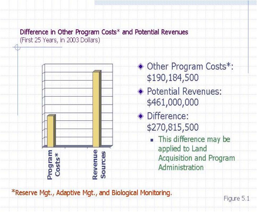
5.5. LOCAL DEVELOPMENT MITIGATION FEES
As described in Section 5.4, if the LDMF is established to finance $635.9 million,110 as opposed to the full acquisition and administration costs of $906.7 million,111 then the LDMF may be imposed at rates lower than indicated in Section 4.8. If the LDMF is calculated to generate $635.9.million using the methodologies described in Section 4.8.4, gross acreage, density, EDU and EBU, the resulting amounts are presented in Tables 5-5 through 5-8, respectively.
The LDMF will be imposed pursuant to Government Code Section 66000 et seq., which allows cities and counties to charge new Development for the costs of mitigating the impacts of new Development. Specifically, Habitat acquisition costs, which are the most significant portion of the overall MSHCP program costs over the next 25 years, along with program administration expenditures will be financed with LDMF funds as they become available. The implementation of the LDMF requires adoption of an ordinance by the County and the participation Cities. The fee ordinance adopted by the Cities and the County should provide for an annual CPI adjustment, and include provisions for fee adjustments should the total fee amounts collected fall short of the amounts needed to mitigate new Development's impact on habitat.
6. RECOMMENDATIONS
With respect to the different fee methodologies presented in Section 4.8, DTA recommends the County and Cities adopt the EBU based fee discussed in Section 4.8.7.5 at rates not to exceed those shown in column [1] and not less that those shown in column [2] of Table 6-1.
DTA is recommending these rates be adopted as the EBU approach equally weights all three of the factors associated with the impacts resulting from new development: lot size, trip generation, and population.
DTA also recommends that the County and City adopt an escalation factor in the ordinances implementing the LDMF and plan on reviewing and updating the Nexus Report every few years to make sure the fee revenues are keeping up with the costs for habitat acquisition.
7. OTHER FUNDING ISSUES
7.1. FESA REQUIREMENTS
According to FESA, an applicant must develop and submit a habitat conservation plan ("HCP") to obtain an ITP. The HCP must specify (1) the likely impact from the proposed takings; (2) the steps the applicant will take to minimize and mitigate such impacts and the funding available for such mitigation; (3) alternative actions considered, and the reasons for not selecting them; and (4) such other measures as the Secretary may require as necessary of appropriate for the purpose of the plan. (See 16 U.S.C. Section 1539(a)(2)(A)). Upon submission of a permit application and related conservation plan, "the Secretary shall issue the permit," if he or she finds, after the opportunity for public comment, that
- the taking will be incidental;
- the applicant will, to the maximum extent practicable, minimize and mitigate the impacts of such takings;
- the applicant will ensure that adequate funding for the plan will be provided;
- the taking will not appreciably reduce the likelihood of the survival and recovery of the species in the wild; and
- other measures required by the Secretary will be met.
One essential condition for the issuance of the permit is contained in Section 1539(a)(2)(B)iii, which requires that the applicant ensure that "adequate funding" for the MSHCP is provided.
The MSHCP funding program, including the LDMF component as presented in Sections 4.7 and 5, was developed to ensure that adequate revenues are to fund MSHCP implementation. Failure to provide for adequate funding as the MSHCP implementation costs occur may result in revocation of the permit.
7.2. ADEQUACY OF FUNDING
Through an annual review process the RCA will approve the use of funds and allocate available funds to the continuous benefit of the MSHCP without imposing additional obligations to Local Permittees. It is likely, however, that during the early years of the MSHCP Conservation Area assembly financing shortages may require debt financing strategies to ensure cash flow needs. During the first three years, the RCA will develop a strategy for financing debt to support the MSHCP acquisition program. Also, the Permittees and the Wildlife Agencies will annually evaluate the performance of the funding mechanisms and, notwithstanding other provisions of the MSHCP, will develop any necessary modifications to the funding mechanisms to address additional funding needs. If, during the annual review process, deficiencies are identified, then the Permittees and the Wildlife Agencies will develop strategies to address any additional funding needs consistent with the terms and conditions of the MSHCP.
Additional funding needs may occur for the following reasons:
If a need for additional funding is projected based upon any event listed above, then local funding sources may be adjusted to cover the need for additional funding to maintain existing MSHCP standards, by identification of new funding sources to supplement existing funding, utilization of contingency funds on a short-term basis, implementation of new tools to achieve conservation, and/or advancement of endowment funds on a short-term basis.
The local funding plan is intended to keep the acquisition of Additional Reserve Lands to support Reserve Assembly roughly proportional with the amount of Development occurring in the Plan Area. Table 7-1 presents the schedule that will be used to determine if additional Conservation is needed to keep Development and Conservation in "rough proportionality" over the 25-year "acquisition period".112
If at the end of any five (5) year period the "rough proportionality" test has not been met, the Permittees and the Wildlife Agencies will meet within 90 days to begin to develop a strategy to address the need for a balance between Conservation and Development.
7.3. LONG-TERM FINANCING FOR MANAGEMENT
Long term financing for management activities beyond the 25-year acquisition period is a twofold approach. After a three-year trial period the RCA will determine which of the two approaches is the most practicable beyond the 25-year acquisition period. A portion of the annual revenues generated under the MSHCP will be contributed toward Conservation Area management, adaptive management, monitoring, and administration of the MSHCP Conservation Area by the RCA (collectively referred to as management costs). Under either approach, management and monitoring costs will increase over time, while acquisition costs will decline as the MSHCP Conservation Area nears completion. When the acquisition process has been completed, funding that was earmarked for acquisition will be shifted as allowed by law to support management and monitoring programs.